about us | links | permit info
Subscribe to Hiking With My Brother Email Subscribe Follow Hiking With My Brother on Facebook Follow Hiking With My Brother on Twitter Hiking With My Brother Picasa Hiking With My Brother YouTube

Kendall Peak - Photosynths

Jer's PhotoTo remind everyone of sunnier days, I saved a photosynth that I put together this summer from the vista of Kendall Peak. I took the photos for this synth as we walked north along the ridge to try an capture what it's like to traverse the peak. To the east, the mountain drops into Commonwealth Basin and rises to Snoqualmie Mountain and Guye Peak. To the west is Rampart Ridge and Alta Mountain. Snoqualmie Pass ski area, and Mt. Rainer are visible to the south, and Red Mountain and the horn of the Mt. Thompson cut the sky to the north.


The second synth is of the unofficially named Kendall Peak Falls. We happened upon these falls in late October when we were taking an alternate route back from Commonwealth Basin along the Pacific Crest Trail. We missed these falls the first time we hiked the trail during the summer because they were obscured behind heavy underbrush. With autumn in full swing, there were fewer leaves, and more rainfall which made it easy to spy these falls on the cliffs above. Unable to resist the allure of clambering to a waterfall, we scrambled through the devils club and up the rocky stream bed for a closer look. - Jer

Barclay Lake Trail #1055

Our Hiking Time: 2h
Total Ascent: 225ft
Highest Point: 2500ft
Total Distance: 4.4 miles
Location: N 47° 47.0400, W 121° 25.5000
Required Permit: Northwest Forest Pass
Difficulty: Easy

Nathan's PhotoAlthough we’re still not completely done with everything we want to do in the I-90 corridor, our focus is slowly shifting northward. Our hike this week was another tentative foray down Highway 2 in search of a new swath of forest to explore. We found exactly what we were looking for in a short hike out to Barclay Lake and an official introduction to the Wild Sky Wilderness.

The 106,577-acre Wild Sky Wilderness is less than ten years old, barclay creek hikingwithmybrotherand parts of it are still winding through the bureaucratic process of being turned over to the Forest Service. Some portions of the Wild Sky are still old growth and truly wild, while others have been logged as recently as the late-60s. In doing a little research, we found that Barclay Lake was not our first time in the Wild Sky Wilderness, which evidently also encompasses Lake Isabel as well.

The Barclay Creek Trail #1055 sits at the end of Forest Road 6024, and is a largely flat, simple trail that follows Barclay Creek for a little over 2 miles to its source, Barclay Lake. Wide and well groomed, the trail wanders past root-wrapped rocks, venerable hemlocks, and moss carpeted undergrowth. Cedar boardwalks occasionally keep boots out of marshy stretches in the trail, and a sturdy log bridge spans Barclay Creek as you approach the lake. Gunn Peak flanks the trail to the north, eventually giving rise to Merchant Peak as you near Barclay Lake. Occasionally Baring Mountain can be seen through the trees, waiting to reveal its craggy features once you reach the lakeside.

barclay lake baring mountain hikingwithmybrotherBarclay Lake lies in a quiet bowl between Merchant Peak and Baring Mountain, somehow giving one the feeling of being deep in the wilderness. Between the well-maintained trail and abundance of campsites – not to mention two pit toilets – it’s clear that Barclay Lake gets a lot of visitors in the warmer months. Standing on the lakeshore it is not hard to understand why. Not only is it peaceful, but the dramatic spire of Baring dominates the scene. Moreover, a short trail capable of transporting the whole family into the wilderness with the minimum of effort adds to the allure. For those looking to climb Baring or continue on to bigger adventures, Barclay Lake makes for a great base camp. For our part, this little trail exposed us to the Wild Sky Wilderness and the potential for dozens of hikes in the immediate vicinity, many of which are sure to be challenging and a bit off the beaten path.

To get there, take Highway 2 to Baring. Near milepost 41 and across from a store, turn left onto 635th up and over the railroad tracks. Asphalt will quickly turn to gravel before shortly coming to a junction. Turn left up Forest Road 6024 and proceed for 4.2 miles to the trailhead at roads end. -Nathan

Barclay Lake

Rainy Lake Trail

Our Hiking Time: 5h 15m
Total Ascent: 2900ft
Highest Point: 3900ft
Total Distance: 8 miles
Location: N 47° 30.6900, W 121° 32.0220
Required Permit: Northwest Forest Pass
Difficulty: Hard

Note: The Middle Fork Road is only open on weekends through 2016.

Nathan's PhotoWe have spent a fair bit of time in the Middle Fork Snoqualmie Valley and trekked down many of the well known trails.  We've also explored some lesser traveled areas and one of our favorites is Rainy Lake.  Sometimes we are in the mood for something with a bit of grit to it, something that might require a little bushwhacking to complete. The Rainy Lake Trail is exactly this type of trail - perfect for hikers who are looking for a good workout and a little adventure.

There are several areas named "rainy" in the Middle Fork area - Rainy Creek, Rainy Lake, and Rainy Mine.  All appear to be named for the above average rainfall the valley receives.  Rainy Creek can be found on maps as far back as 1907 and likely lent that name to the lake.  For decades, Rainy Lake was a destination for backwoods fisherfolk, who seem to be responsible for cutting the rough path to the shore.  Trail Blazers like George Lewis hauled trout fry up this route to stock Rainy Lake (among many other lakes in the area).  A plaque honoring Lewis' efforts can be found with a little exploration of the area around the lake.  Over the years the trail was maintained mostly by users.  It may be that the Forest Service was involved with the trail at some point, but if that ever was the case, the trail is long since abandoned.  Today the forest is kept at bay by helpful hikers and anglers who clear a little brush or re-route the trail around major blowdowns.  While in recent years the underbrush has gotten the upper hand, there is some talk of reclaiming this trail in the coming years to make the lake a little more accessible.

The trail begins at the Middle Fork Trailhead, crosses the Gateway Bridge and veers right onto the newly upgraded Pratt Lake Connector Trail. As you leave the bridge, enter the Alpine Lakes Wilderness and follow downstream toward Stegosaurus Butte. From the new trail you can see the old riverside trail below, and after .25 mile stroll you'll reach a bridge spanning Rainy Creek. Cross the bridge and a few dozen feet beyond you'll find the unmarked junction with the Rainy Lake Trail. Head uphill, trading the wide trail for more difficult terrain.

From the main trail, follow the narrow bootpath through lush forest and mossy undergrowth. Rainy Creek is your merry companion for the first portion of your journey, as you climb ever upward toward the lake. The path alternates between very steep inclines and occasional plateaus, while traversing blowdowns and occasional talus fields. While some portions are a bit overgrown, the trail is easy to follow, although mud and slick roots can make your ascent that much more challenging. The occasional views of Mt. Garfield are excellent and the rugged trail lends a pleasant feeling of seclusion. Eventually, after many scrambles over fallen logs and trickling streams, descend down to the shores of Rainy Lake nestled beneath the exposed rock face of Preacher Mountain. An faint trail can be found to the right as you reach the lake, leading to decent campsites and a memorial plaque. Looking for more? There is a scramble route out to Little Rainy Lake that can be used to scramble to the summit of Preacher, but it’s reportedly very overgrown and something of a struggle to navigate.

This is a difficult hike. Not only is it a lot of elevation, but the route is rough and not for everyone. Be prepared to occasionally use your hands to find some balance and make sure to bring some poles to help keep you steady as you work your way up the steep creek valley. Those willing to brave the trail can look forward to the quiet solace of this pristine alpine lake. Certainly, Rainy Lake would be a great base camp for those that want to summit Preacher or the Pulpit, but it is also a lovely and peaceful destination in itself. Whether you're looking for something a little different or just looking for some solitude, Rainy Lake is a great choice.

To get there, take Exit 34 off I-90 and take a left on 468th Ave. Follow the road past the truck stop for about a half-mile until you reach SE Middle Fork Road, also known as Forest Road 56. Turn right and follow the road for a few twists and turns, keeping left when the road splits. After 2.2 miles reach SE Dorothy Lake Road.  Take a left, passing the Mailbox Peak Trailhead as you navigate the nearly 11 miles of forest road to the Middle Fork Trailhead.  The road is currently in the process of being upgraded and paved and is only open to the public on the weekend.  The project is expected to be completed by fall of 2016.  The signed trailhead and ample parking area is on the right side of the road, find the trail to the Gateway Bridge at the north end of the lot. -Nathan

Post updated 10/10/2015
Print Google Directions >>

Rainy Lake

Coal Creek Falls - De Leo Wall Loop - Cougar Mountain

Our Hiking Time: 2h 30m
Total Ascent: 800ft
Highest Point: 1100ft
Total Distance: 5.5 miles
Location: N 47° 32.0760, W 122° 7.7220
Required Permit: None
Difficulty: Easy

Nathan's PhotoLingering holiday obligations kept us from venturing too far from home this week. Instead, we headed out to Cougar Mountain and the Red Town Trailhead to tour a different portion of the sprawling park.

cougar mountain cold creek falls hikingwithmybrotherCougar Mountain’s friendly greenery gives little indication of the industrial history of the area. Back in 1863, coal was discovered on Cougar Mountain. Over the next 100 years, miners would pull 11 million tons of coal from the mountain before finally sealing the mines in 1963. All that coal prompted folks to dub the area "Newcastle Hills," after England's coal-rich city of Newcastle. Soon, Newcastle Hills coal drove the the creation of Seattle's first railroad, which hauled coal from Cougar Mountain out to Lake Washington and eventually Elliot Bay. Mining towns cropped up around shafts bored into the mountain. One of those settlements was Red Town, named for the color most of the buildings were painted. The current Red Town Trail largely follows what was then Hill Street, the town's main thoroughfare running past houses, schools and businesses. Most of these settlements faded away as the coal industry declined in the 1920s, and by the time World War II was over, neighbors sought to move beyond the area's mining past, and renamed it Cougar Mountain. Today, with a little effort, one can still find the rusting artifacts, lingering cement foundations, and abandoned equipment of those bygone industries. More likely than not, a friendly interpretative sign will be nearby to lend historical context to many of the lingering traces of Cougar Mountain's past.

With 36 miles of official trails and many more miles of “unofficial” or abandoned trails, there is a lot to see on Cougar Mountain. We mapped out a rough route taking us up to the De Leo Wall and past Coal Creek Falls, though it required hop-scotching between a surprising number of cougar mountain cold creek falls hikingwithmybrothertrails. Fortunately, trails are coded and well signed, keeping confusion down to a minimum.

We took the Wildside Trail towards De Leo Wall, a rocky outcropping that affords something of a view of the surrounding housing developments. Trails are well maintained by thousands of booted feet and an army of volunteers. Alders and hemlocks dominate the low forest riddled with streamlets and occasional bogs. On our way back down from the wall we hooked over to see the underwhelming Far Country Falls before pushing on to Coal Creek Falls. The Coal Creek Falls Trail is mild and contains few ups and downs, making it a perfect trail for the kids or trail running, both of which were in attendance on a rainy Sunday morning. The 25’ falls can make a good rest stop along the route or are a popular destination in and of themselves.

While not our usual high-adventure, Cougar Mountain does manage to have a little something tcougar mountain cold creek falls hikingwithmybrothero offer everyone – history, waterfalls, miles of trail, and accessibility for the whole family. Heck, there’s even a zoo. Proximity to the city means there will be a lot of folks to share the trail with, though it isn’t too difficult to head out to more remote parts of the park to find some peace and quiet.

To get there, take I-90 to Exit 13. Head right up the hill on Lakemont Boulevard just over three miles. Look for the entrance to the Red Town Trailhead on the left side of the road. - Nathan
< Cold Creek Falls - De Leo Wall

Otter Falls, Lipsy Lake, and Big Creek Falls

Our Hiking Time: 5h
Total Ascent: 700ft
Highest Point: 1800ft
Total Distance: 9.5 miles
Location: N 47° 35.2200, W 121° 28.0560
Required Permit: Northwest Forest Pass
Difficulty: Easy

Nathan's Photo
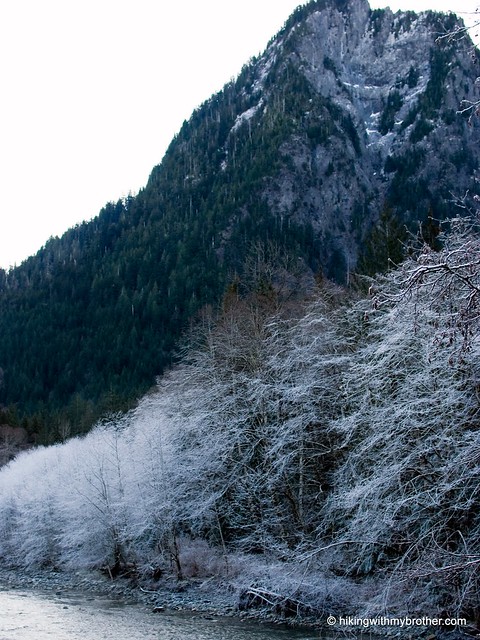
The Middle Fork Snoqualmie is once again open and after our trip up to Tin Cup Joe Falls, we were itching to do some more exploring in the area. One never knows when the road will wash out again, and we want to get as many hikes in while we can. Before we knew it, we were trekking down a former logging road in search of Otter Falls.

The hike begins at the Taylor River Bridge at the end of Forest Road 56, sometimes also called the Lake Dorothy Road, or Lake Dorothy Highway. Back in the 1950sotter falls taylor river hikingwithmybrother, there was an effort to ram a road up through the river valley to connect North Bend to Skykomish. The route was to follow the old Taylor River Road, built by loggers to truck lumber back to Seattle. Evidently, some work was done to facilitate the project – mostly bridgework and some dirt roads cut – but it was ultimately blocked by the creation of the Alpine Lakes Wilderness. Today the Taylor River Road is but a whisper of the logging road it once was and might have remained had the construction continued; instead it feels like the quiet footpath many people hoped it would become.

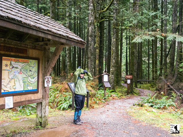
After you park and gear up, cross the bridge and keep to the right at the Y in the trail. Enjoy a stroll next to the alder-lined Taylor River. Craggy Mt. Garfield makes an early appearance on the other side of the river, eventually yielding the stage to Treen Peak. After three leisurely miles, you’ll hit Marten Creek and what is known as Martin Falls. Small but pretty - note the greens and oranges of the rocks that can be seen in the pool below the falls. If you have adventure on your mind, there is an old bootpath on the far side of the bridge leading up to Marten Lake, a little over a mile upstream.

Pushing past, we made for Otter Creek is a little over a mile up the trail. Keep an eye for the otter falls taylor river hikingwithmybrother“Otter Falls” sign, or for a cairn letting you know to head up. There isn’t much of a formal trail, it’s a short uphill battle to get to the falls, so just chose the path of least resistance. Otter Falls can be seen once you reach the top – it’s tempting to head straight for them, but resist the urge and instead veer toward the right of the falls for an easy place to cross the creek and avoid the brambles.

As impressive as the falls are from here, you can really only see about half of it. Otter Creek slides almost half a mile down the exposed granite to fall into Lipsy Lake below. Linger here for lunch or, if you haven’t had your fill of waterfalls just yet, head back down to the main trail and push onward. About a half-mile ahead you’ll reach a sturdy concrete bridge, perhaps a remnant of the Lake Dorothy Highway project that never was. The bridge spans the very cleverly named Big Creek and showcases Big Creek Falls. Although it lacks the serenity of Otter Falls, in some ways Big Creek Falls is a little more engaging. The angle of the rock is a bit steeper, increasing the speed of the water and making things more dramatic. Check them both out and let us know which one you like better.

The trail is not too long, and there isn’t much in the way of elevation, otter falls lipsy lake hikingwithmybrothermaking it an easy hike without too much company. Despite being relatively close to Seattle, the Taylor River Road feels remote and much further from civilization. This is one to take some less experienced hikers on to give them a whiff of the wilderness. It is also easy to extend your hike beyond Big Creek Falls by pushing on to Snoqualmie Lake, though be warned that it is only a few miles, the lake is roughly 1500ft higher in elevation.

To get there, take Exit 34 off I-90 and take a left on 468th Ave. Follow the road past the truck stop for about a half-mile until you reach SE Middle Fork Road, also known as Forest Road 56. Turn right onto the Middle Fork Road and follow the twists in the road until the pavement runs out. Continue on FR 56 for 12 miles, crossing the Taylor River. Once across, keep to the left for another quarter mile to the end of the road and the trailhead. -Nathan

Otter Falls
Copyright 2008-2016 - hikingwithmybrother.com
hikingwithmybrother@gmail.com