Total Ascent: 250ft
Highest Point: 850ft
Total Distance: 2.0 miles
Location: N 48° 3.0416, W 123° 47.3033
Required Permit: None
Difficulty: Easy
 We’re always on the lookout for short hikes that will help break up a long car ride. These are usually hikes that are a little too short to be worth a long drive, but are perfect for short side trips. Marymere Falls is a great example of a roadside hike that can be added to any trek past Lake Crescent.
 Barnes Point is one of the only flat areas on the rugged south shore of Lake Crescent. Formed by a buildup of sediments created by a glacier that has long since receded, the area has likely attracted people for many generations. Back in 1896, the Barnes family purchased a 135-acre homestead, making it among the first settlements on the lake. As such, the family name was given to the general area as well as the creek that flowed through their homestead
 There is some confusion with the historical record regarding exactly which members of the Barnes family settled this area and how they are related. To clarify, William and Sarah Barnes had six children: Pierre, Charles, Paul, Mary Alice, Edward and Horace. After William died in 1878 the family moved west. Charles was a member of the 1899-1900 Seattle Press Expedition, a five man expedition sponsored by the Seattle Press newspaper to explore the interior of the Olympic Peninsula and report their findings. Perhaps motivated by what Charles found on his journey, the family bought their homestead on Lake Crescent and Paul is listed as the purchaser of the homestead. In 1906, the family built the Marymere Hotel, the first resort on the south side of the lake. Both the hotel and Marymere Falls are said to be named for Mary Alice. The Marymere Hotel was purchased by Rose A. Littleton shortly before it burned to the ground in 1914. Undeterred, Littleton replaced it with the Rosemary Inn that same year, portions of which still stand today.
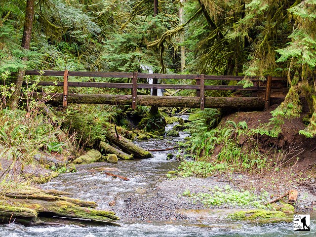
The trail begins from the Storm King Ranger Station, following a well-signed path as it slopes gently toward Lake Crescent. Almost immediately, the paved trail enters a tunnel under Highway 101 and emerges into a mossy forest of cedar and hemlock. The path continues gently for about a half-mile to a junction with the Barnes Creek Trail. Veer right over the creek and continue a short distance past the Mt. Storm King Trail to the short loop at the end of the trail. To the left the path continues out to a view of the base of the falls; to the right the trail climbs up the hillside to a viewpoint before dropping back down to the creek. The upper viewpoint provides a better vantage point for watching Falls Creek tumble more than 100 feet down the cliffs to a small pool before joining Barnes Creek a short distance downstream.
 This hike is perfect if you’re looking to stretch your legs on the drive out to the Olympic Peninsula. Short and not too challenging, this low-elevation hike is accessible year-round and should be approachable for even the youngest of hikers. If you’re looking for a little bit more trail time, consider exploring the short Moments through Time Loop or sections of trail along the lakeshore.
 To get there, take the Bainbridge Island Ferry, following State Route 305 through Poulsbo to State Route 3. Follow SR 3 to the Hood Canal Bridge, taking a left over the bridge onto State Route 104. Follow SR 104 as it merges onto US 101 and continue another 36 miles to Port Angeles, taking a left on Lincoln Street to stay on US 101. Continue 21 miles to the Storm King Ranger Station and take a right. The entrance will be signed for Marymere Falls. Follow the signs to the ranger station to find parking and the trailhead. -Nathan
Print Google Directions >>