about us | links | permit info
Subscribe to Hiking With My Brother Email Subscribe Follow Hiking With My Brother on Facebook Follow Hiking With My Brother on Twitter Hiking With My Brother Picasa Hiking With My Brother YouTube

Scorpion Mountain via Johnson Ridge Trail #1067

Our Hiking Time: 4h 5m
Total Ascent: 2600ft (2300ft in; 300ft out)
Highest Point: 5540ft
Total Distance: 8 miles
Location: N 47° 47.5440, W 121° 11.8620
Required Permit: None
Difficulty: Hard

Nathan's Photo
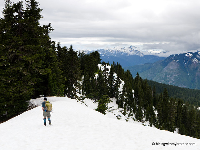
This week we decided to find out if summer had reached the mountaintops along the Highway 2 corridor, holding on to the faint hope that snows had miraculously receded. We chose the somewhat obscure Scorpion Mountain, assuming its relatively low elevation would mean no lingering snow. The bad news? We encountered a lot more snow than we should have in July. But the good news is that the snow is definitely on the way out – at least under 6,000ft.

scorpion mountain hikingwithmybrother
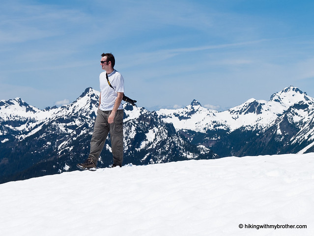
This can be a challenging hike. The elevation gain is not insignificant, especially with all the ups and downs. While not an ideal hike for the whole family, many hikers should be able to navigate the sometimes rough trail to the top. The amazing views Scorpion Mountain offers are more than worth the extra workout. The lengthy drive down forest roads keeps this hike a little under the radar, so don’t expect to be sharing the views with a lot of company.

There's a lot more to Scorpion Mountain, and you can learn all about it in our book, Hiking Through History Washington.  You'll find a trail map, route descriptions, history, and more for this and many more hikes throughout the State. Help support hikingwithmybrother.com and the work we do by picking up a copy!

To get there, take Highway 2 out past Skykomish to milepost 50. Take a left onto FR 65, also known as the Beckler River Road. Continue for almost seven miles to a junction, taking a sharp right up FR 6520 and following it for almost three miles to an unsigned junction. Veer left here, continuing on FR 6520 for another four miles to the next junction. Here, take a right up FR 6526 and follow it for about a quarter mile to the last junction, taking a left up to a small trailhead at road’s end. -Nathan

Print Google Directions >>

Scorpion Mountain

Greenwater and Echo Lakes Trail #1176

Our Hiking Time: 5h 40m round trip to Echo
Total Ascent: 500ft to Greenwater, 1900ft (1600ft in and 300ft out) to Echo
Highest Point: 3000ft to Greenwater, 4100ft to Echo
Total Distance: 4 miles round trip to Greenwater, 13.0 miles round trip to Echo
Location: N 47° 5.2500, W 121° 26.8740
Required Permit: Northwest Forest Pass
Difficulty: Easy to Greenwater, Moderate to Echo

Download GPX File

Nathan's PhotoThis week we headed out toward Crystal Mountain and Highway 410 to explore the Greenwater Lakes Trail out to Echo Lake. Because this area is extremely popular for both hiking and camping during the summer, we planned an early start to try and get the jump on the crowds on a sunny weekend. We managed our early start, but not avoiding the crowds – the parking lot was already packed by the time we geared up.

greenwater echo lake hikingwithmybrotherRushing rivers, placid lakes, and wild forests continue to bring hikers out to the Greenwater Lakes trail. The hike out to Greenwater Lakes is very approachable for any almost anyone. This makes it a great option for young campers on their first overnight or backpacking experience. Beyond the lakes the trail does become more difficult, gaining a fair amount of elevation, so be prepared for more of a workout. Those looking to get away from the crowds will want to avoid this approach to Echo Lake, which can also be accessed via the Corral Pass trailhead. Still, we definitely recommended this hike for getting the whole family on the trail or getting those reluctant friends out on a hike.

There's a lot more to Greenwater and Echo Lakes, and you can learn all about it in our book, Hiking Through History Washington.  You'll find a trail map, route descriptions, history, and more for this and many more hikes throughout the State. Help support hikingwithmybrother.com and the work we do by picking up a copy!

To get there, take I-5 south to Highway 18 Exit 142A. Follow Highway 18 into Auburn and take the SR 164 exit. Head left on SR 164 through Enumclaw to SR 410. Turn left onto SR 410 and drive about 20 miles through the town of Greenwater, past the fire station to FR 70 on the left. Follow FR 70 a little over nine miles to FR 7033. Take a right and follow the road to the trailhead. -Nathan

Print Google Directions >>

Greenwater and Echo Lakes

Goat Lake - Elliott Creek Loop Trail #647

Our Hiking Time: 5h 30m
Total Ascent: 1600ft
Highest Point: 3200ft
Total Distance: 10.5 miles
Location: N 48° 1.1040, W 121° 20.9640
Required Permit: Northwest Forest Pass
Difficulty: Moderate

Nathan's PhotoThis week found us back out on the Mountain Loop Highway trekking up the Elliott Creek Trail to Goat Lake. A sunny summer day was the perfect chance to tackle a popular hike that has something for everyone – history, waterfalls, and an alpine lake. It felt like maybe, just maybe, summer had finally arrived.

Popular with both day hikers and backpackers, Goat Lake sees some significant traffic on summer weekends. And it’s easy to see why. While the trail is on the longer side, the grade is mostly gentle and the trail is clear and well-maintained, making this hike approachable for most goat lake elliott creek hikingwithmybrotherhikers. The destination is stunning; on a sunny day the reflection of snow-covered mountaintops in the lake is an impressive sight. And, if that wasn’t enough, getting a close-up look at massive MacIntosh Falls is more than worth a four mile hike. We recommend this hike for almost everyone, though be prepared to share the views if you go on a weekend.

There's a lot more to Goat Lake and Elliot Creek, and you can learn all about it in our book, Hiking Through History Washington.  You'll find a trail map, route descriptions, history, and more for this and many more hikes throughout the State. Help support hikingwithmybrother.com and the work we do by picking up a copy!

To get there, take I-5 North to Exit 194. Follow Highway 2 for about two miles. Stay in the left lane and merge onto Lake Stevens Highway 204. Follow for two miles to Highway 9. Take the left onto Highway 9 toward Lake Stevens. In just under two miles, you’ll reach Highway 92 to Granite Falls. Take a right and follow for about nine miles to the Mountain Loop Highway. Follow the MLH for a little over 30 miles to the end of the pavement. Continue another three and a half miles to FR 4080. Take a right and follow FR 4080 about a mile to the Elliott Creek Trailhead. – Nathan

Print Google Directions >>

Goat Lake Elliott Creek Loop

Thorp Mountain Lookout via Thorp Creek Trail #1316

Our Hiking Time: 5h 20m
Total Ascent: 2300ft
Highest Point: 5854ft
Total Distance: 6.5 miles
Location: N 47° 22.2420, W 121° 12.5160
Required Permit: None
Difficulty: Hard

Nathan's PhotoAfter all the luck we had dodging late snows up on Hex Mountain, when another sunny hiking day presented itself we headed back out over Snoqualmie Pass to continue exploring the trails around Cle Elum Lake. This time we set our sights on the long approach to Thorp Mountain Lookout hoping for some big views off of Kachess Ridge – we were not disappointed.

thorp mountain hikingwithmybrother
Thorp Mountain, along with Thorp Lake and Thorp Creek, are all named after Fielding Mortimer Thorp, an early pioneer in the Yakima Valley. Often attributed as the first permanent settler in the Valley in 1860, Thorp also went on in 1885 to found a small town. Years later, the town would be named Thorp by the Northern Pacific Railroad in honor of another member of the Thorp family. In the early 1930s, the US Forest Service built a fire lookout on the summit of Thorp Mountain, along with lookouts on nearby Jolly Mountain and Red Mountain. Today only the Thorp Lookout remains, still staffed by the Forest Service a few months out of the year.

Most hikers approach Thorp Mountain from the Knox Creek Trailhead, which is both shorter and easier than the Thorp Creek Trail we hiked. Currently, this route is made more complicated by the absence of a bridge over Thorp Creek near the trailhead. The creek might be friendlier in a few thorp mountain hikingwithmybrotherweeks after this year’s belated thaw, but currently it’s knee-deep, fast-flowing and ice-cold. Cross with caution.

Once across follow a converted logging road as it parallels the creek and takes you through recovering clearcuts. Slide alders and huckleberries line the trail, rising above the grass and brush that cannot quite disguise acres of bleached snags and stumps. Younger firs and pines eventually begin to appear, making this area more attractive to wildlife – we managed to stumble upon some elk and deer on our way up. Soon the trail begins in earnest, quickly transitioning from mild switchbacks to steeper grades.

Alas, we were not able to evade the lingering snows. We quickly lost the trail and found ourselves slogging up the icy mountainside. Still, we found the junction leading the half-mile down to Thorp Lake but chose to forge on to the ridgeline, and the rocky climb up to the lookout. This last stretch is a little steep, but the expansive views from the lookout are more than worth it. Mount Rainier rose above the shimmering blue of Kachess Lake. Nearby Red Mountain is easy to pick out to the northeast. Below, Thorp Lake is nestled amongst the trees. And beyond, the horizon is filled with hundreds of snow-topped peaks. Find a spot to settle down to take it all in.

thorp mountain hikingwithmybrotherWe liked this approach. It was a little more difficult, but it definitely made up for it in solitude. It also offers the possibility of making a loop out to the summit of Red Mountain following trails once used to connect the lookouts. The parts of the trail that were not covered in snow were in pretty good shape, but it’s still probably not for everyone. With over 2000ft of elevation in a little over three miles, it will definitely give your legs a work out. If you’re looking for a quiet alternative to a popular destination with some amazing views, give Thorp Creek Trail a try.

To get there, take I-90 to Exit 80. Head left over the freeway following Bullfrog Road to SR 903. Follow 903 for 16 miles through Roslyn and along Cle Elum Lake to FR 4308. Turn left onto FR 4308 and follow a little over 3 miles to a signed intersection. Head right down FR 4312 for the Thorp Creek Trail. Continue on FR 4312 for a mile and a half to a gated spur veering to the right. Find a spot to park here and hit the trail. –Nathan

Thorp Mountain Lookout
Copyright 2008-2016 - hikingwithmybrother.com
hikingwithmybrother@gmail.com