about us | links | permit info
Subscribe to Hiking With My Brother Email Subscribe Follow Hiking With My Brother on Facebook Follow Hiking With My Brother on Twitter Hiking With My Brother Picasa Hiking With My Brother YouTube

Hiking with My Brother on Backpacker.com


Nathan's Photo
We’re excited to announce that we are now working with Backpacker Magazine to help share and promote hikes around the Pacific Northwest. In recent years, Backpacker has been expanding their focus beyond multi-day backpacking treks to encompass shorter day hikes close to major cities. When editors at the magazine went looking for local hikers to help catalog days hikes, they quickly found hikingwithmybrother.com and enlisted us to lend a hand. Not only will we be sharing our hikes with the Backpacker.com community, occasionally our submissions will be presented as a featured “Destination” by Backpacker Magazine.

The first hike the Backpacker folks have chosen to feature is Poo Poo Point. We’re hoping as the season heats up we’ll be able to get some interesting and unique hikes out to that community.

Sadly, we missed out on our hike last week, but we’ve got a great hike lined up for this weekend, so stay tuned. - Nathan

East Tiger Mountain

Our Hiking Time: 3h 20m
Total Ascent: 1600ft
Highest Point: 3000ft
Total Distance: 8 miles
Location: N 47° 29.2920, W 121° 56.8410
Required Permit: Discover Pass
Difficulty: Moderate

Nathan's PhotoWe’ve logged a lot of time on Tiger Mountain. Most of this has been up to West Tiger #3 via the Cable Line, but after hiking to Poo Poo Point we realized there was a lot of the mountain we’d yet to explore. With snow falling on the streets in Seattle, we thought something a little closer to home was the right choice, so we packed up and headed out the Highway 18 and East Tiger Mountain.


east tiger mountain hikingwithmybrotherThe roughly 14,000 acre Tiger Mountain State Forest was formed in 1981. Shortly thereafter, in 1989, the Tiger Mountain Natural Resource Conservation Area was formed, adding further protections to the 4,400 acres of the most popular recreation areas of Tiger Mountain. The Washington Department of Natural Resources (DNR) manages the mixed use of the forest, including the maintenance of approximately 70 miles of trails and roads.

The journey up East Tiger is entirely on gravel maintenance roads giving access to the various radio towers and antennas that reside at the summit. Most of these roads are built on the roadbeds of logging roads dating back to the 1920s. This means that while East Tiger is the tallest of the Tiger family of peaks, standing just over 3,000ft, its roads have a very mild grade, gently guiding you up the mountain. Occasional views of Taylor Mountain can be seen through the mixed second-generation forest that lines both sides of the road, though the real prize is the broad vista at the end of the hike, showcasing Mt. Rainier, valleys and the Puget Sound.

Or so we’re told. There were no views for us because the low-lying clouds and fog reduced visibility to a few hundred feet. As we gained elevation, our hike became more of a slog as we found ourselves sinking past our knees in the powdery snow. Upon reaching the summit, strong winds and increasing snow flurries made our stay very short.

East Tiger is another great trail for snowshoeing, biking, or traileast tiger mountain hikingwithmybrother running with lots of room to share the road. At the 3 mile mark, the road intersects with the Main Tiger Mountain Road, giving access to other peaks and trails in the Tiger Mountain State Forest. The proximity to the city also makes this a great destination for a quick tromp through the woods while avoiding the crowds at West Tiger.

To get to East Tiger, take I-90 to Exit 25 Highway 18 junction. Take Highway 18 south for about 5 miles to the Tiger Summit Trailhead parking lot which will appear on your right. -Nathan

Print Google Directions >>

East Tiger Mountain

CCC Trail - Western Trailhead

Our Hiking Time: 4h 10m
Total Ascent: 700ft
Highest Point: 1600ft
Total Distance: 10.5 miles
Location: N 47° 29.4000, W 121° 41.2800
Required Permit: Discover Pass
Difficulty: Easy

Nathan's Photo
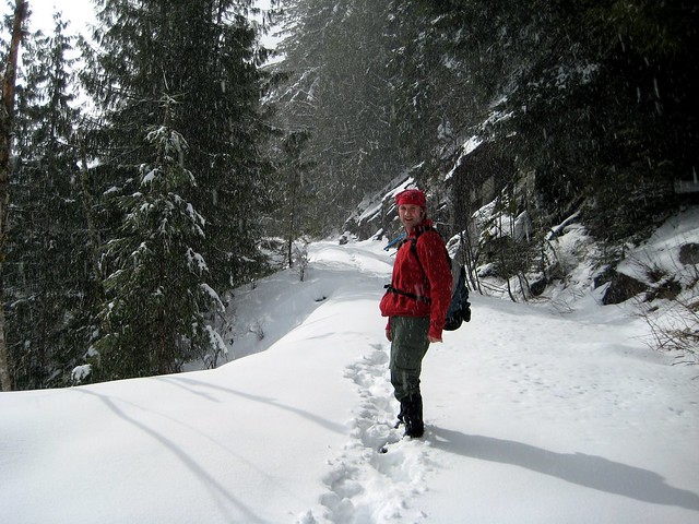
Weather sometimes conspires to force us down trails we’d otherwise been avoiding for months. This week, late snows shied us away from more rugged expeditions into the wilderness, and instead pointed us squarely at the CCC Road. Our apprehensions about trekking down a logging road were confirmed when we noticed that even the ever-gushing Harvey Manning is a bit lackluster in his description of the route. Still, because the 22-mile road is central to many other hikes in the Middle Fork area, we thought it justified at least an exploration.

Running beneath Mt. Teneriffe and Green Mountain, the CCC Road ccc trail hikingwithmybrothersnakes its way toward Taylor River. First blazed by the Depression-era Civilian Conservation Corps in the 1920s to help facilitate access for timber and mining interests, it thrived as the only reliable access to the area before being supplanted by the more modern Middle Fork Road (FR 56). Although it was not so long ago that the area was a haven for a wide variety of unsavory activities, the road is now largely closed to motorized vehicles and is in the middle of the slow transition from road to trail. The clear cutting from the 1960s is still apparent in young forest that lines the trail, though enough time has passed that the ugliness has largely been obscured.

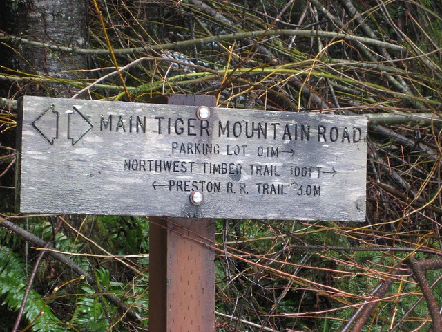
However, much of the trail from the south is still very much a road, with the first mile or so still being actively used as access to private property. The second mile is a wide swath of Douglas Fir monoculture, a legacy of the callously efficient timber practices of fifty years ago. At about 2 1/2 miles, note the trail up to Green Mountain on your left, marked by a high rusty gate barring entrance to a long-abandoned timber road. Continuing on, the road starts a very gradual descent toward the Middle Fork Snoqualmie. Streams and rivulets of various sizes pass through culverts ccc trail hikingwithmybrother
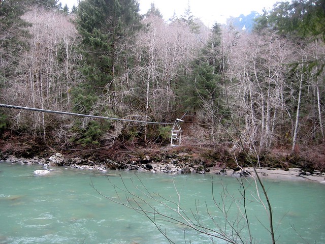
or cut across the trail for the next few miles, as the forest matures and diversifies. Alders and cedars begin to appear alongside the Douglas Firs, and the road begins to narrow and become something more akin to a trail. The feeling that we’d somehow left a logging road for a hiking trail was helped along by pleasant views and engaging terrain. Our spirits thus bolstered, we were almost reluctant to stop at the half-way point just past Big Blowout Creek, where a spur connects the CCC road to FR 56.

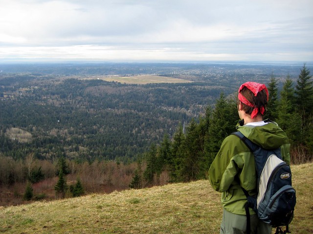
The CCC Road offers some stunning vistas and expanses, showcasing Russian Butte, Mt Garfield, Bessemer Mountain and Mailbox Peak as well as the valley floors they preside over. Unfortunately, much of the approach to these views was plodding and flat, great for the biker or equestrian, but a lot of mundane and unimpressive ground to cover on foot. Although, the same snow that forced us onto the trail reminded us that during the winter months, the road could be a great introduction to snowshoeing – most of the trail is flat and friendly, as well as being comfortably close to civilization. Beyond some light snowshoe experimentation, however, if you’re just out for a pleasant walk in the woods, we recommend you skip the west end of the CCC Road and access the route either via the spur off of FR 56 or from the east end.

The western entrance to the CCC Road can be reached by taking ccc trail hikingwithmybrotherExit 32 off I-90 and heading left on 436th Ave. Proceed on 436th Ave to North Bend Way and turn left. Watch for Mt. Si Road to appear on your right in about a half-mile. Follow Mt. Si Road for about 5 miles, past Little Si and Mount Si to the school bus turnaround that marks the Mt. Teneriffe trailhead as well as the end of the county-maintained road. Manning suggests you park here and huff it the mile to the gated CCC Road, as this is the closest designated parking area. We chose instead to drive the graveled road to the gate and park unobtrusively on the shoulder. Pile out and hit the trail, the sooner you start the sooner you’ll put the less-enjoyable first miles behind you. - Nathan

Print Google Directions >>

CCC Trail - Western Trailhead

Stegosaurus Butte

Our Hiking Time: 1h 30m
Total Ascent: 1000ft
Highest Point: 2100ft
Total Distance: 1.75 miles
Location: N 47° 32.5260, W 121° 31.9440
Required Permit: Northwest Forest Pass
Difficulty: Moderate

Nathan's PhotoSometimes you just want to have some adventure. To go places perhaps a little more wild and remote than a well-worn footpath to a scenic overlook or civilized waterfall. A trek out to Stegosaurus Butte looked to fit the bill. There we hoped to see if Manning’s vision of carving out a “family hike” up the side of this smallish granite ridge next to the Middle Fork Snoqualmie River had become a reality, or if the proposed trail had languished and faded beneath the advancing forest.

To get there, take Exit 34 off I-90 and take a left on 468th Ave. stegosaurus butte gateway bridge hikingwithmybrotherFollow the road past the truck stop for about a half-mile until you reach SE Middle Fork Road, also known as Forest Road 56. The road has a few twists and turns, but continue on until the asphalt ends at Mailbox Peak Trailhead. Beyond, some washouts have occurred this season and while the road is passable, there are some deep potholes and places where the road has been severely eroded. Forge on for a little over 10 miles to the well-signed Middle Fork Trailhead parking lot. The Middle Fork Trail #1003 begins at the north end of the lot and almost immediately spans the river via the Gateway Bridge constructed in 1993 in an effort to promote recreation in the Middle Fork area.

After crossing the bridge, a sign that reads “Main Trail” directs you to the left. Head instead to the right along a less traveled but still discernable trail. Tromp along the rocky banks of the Middle Fork Snoqualmie for a few hundred yards over and around logs and boulders blocking the trail. Rounding the end of the butte, the trail curves up and away from the bank and abruptly seems to end. Simply continue forward and away from the river and quickly find the roughly hewn trail marked with bright fluorescent pink tags.

stegosaurus butte mt. garfield hikingwithmybrotherA great deal of trail construction seems to be underway, with portions of the trail defined by logs and branches, and blowdowns cleared or circumvented. While Manning’s concept is still a work in progress, between the boot-trodden outline of the path and the trail markers we never lost the trail. The bulk of the hike forgoes niceties such as switchbacks - trailblazers instead opted to cut a leg-burning bee-line straight to the top. Fortunately, the trail is short and the almost brutal ascent is over quickly, yielding great views of the massive and imposing rock face of Mt. Garfield to the north and Preacher Mountain to the far south. Rainy Creek flows through the valley to the south, beneath a prominence unofficially known as “The Pulpit”. Settle down for a snack in the grassy open areas before breaking out the hiking poles to help navigate the steep descent back down. - Nathan

Print Google Directions >>

Stegosaurus Butte

Poo Poo Point

Our Hiking Time: 1h 30m
Total Ascent: 1700ft
Highest Point: 1800ft
Total Distance: 4 miles
Location: N 47° 29.9730, W 122° 0.4870
Required Permit: Discover Pass
Difficulty: Moderate

Nathan's PhotoShort on time this week, we returned to Tiger Mountain to explore the curiously named Poo Poo Point. Years ago, Harvey Manning decided to christen the area in honor of the “poo poo” sound made by logging steam whistles. These same whistles presumably helped create the large open fields at the top. Today, these fields are used as a makeshift airport for both hang gliders and paragliders, managing to accommodate both launches and landings.

Traditionally, the Poo Poo Point Trail begins at the Issaquah High School and gently meanders its way 4 ½ miles up to the top. Lacking the time for a 9-mile excursion, we opted to take the moretiger mountain poo poo point hikingwithmybrother direct Chirico Trail to our destination, located a few miles down the road from the high school at the paraglider landing field.

The short hike up the side of Tiger was reminiscent of the Cable Line: a narrow trail blazing its way to the top as quickly as possible. Despite the drizzle, we were joined by many a hiker and more than a few canine companions as we switchbacked through the young forest. We passed many lesser-used trails branching off; some reconnected back up with the main thoroughfare, while others disappeared intriguingly off into the distance. Feeling adventurous, we took one of these paths on our way back down. Unfortunately, our explorations spit us out miles from the parking lot, forcing us on an unpleasant walk down the busy Issaquah-Hobart Road to get back to the car.

The two landing fields offer great views of Squak, Cougar, and Lake Sammamish to the northwest, and Mt. Rainer to the southeast. Take some time to marvel at the Astroturf runway and what it would mean to take a running leap into the air from here. Though moderately steep, this trail is short enough to coax the whole family up, though the narrow trail often becomes slippery with mud after prolonged rain.

To get there, take I-90 to Exit 17 and hang a right on Front Street.tiger mountain poo poo point hikingwithmybrother Front will take you through historic Issaquah before changing into the Issaquah-Hobart Road. Continue for about five miles until you see a large grassy field and a parking lot on your left. This is the paraglide landing area. Park - trail begins on the other side of the field. - Nathan

Print Google Directions >>

Poo Poo Point
Copyright 2008-2016 - hikingwithmybrother.com
hikingwithmybrother@gmail.com