about us | links | permit info
Subscribe to Hiking With My Brother Email Subscribe Follow Hiking With My Brother on Facebook Follow Hiking With My Brother on Twitter Hiking With My Brother Picasa Hiking With My Brother YouTube

Deep Creek Trail #1196 to Noble Knob

Our Hiking Time: 6h 15m
Total Ascent: 3600ft
Highest Point: 6,011ft
Total Distance: 11.8 miles
Location: N 47° 1.6616, W 121° 29.4533
Required Permit: None
Difficulty: Hard

Nathan's Photo
Over the years we’ve found that many popular hiking destinations often have underused alternative approaches. Such approaches provide an opportunity to head back to a familiar mountaintop or alpine lake to expereince it in a whole new way. Recently, we found ourselves on one of these less-traveled trails climbing our way up Dalles Ridge to Noble Knob via the Deep Creek Trail #1196.


There are quite a few Deep Creeks in Washington, most named for the gully or gorge the creek tumbles through. The Deep Creek on Dalles Ridge was named by the Forest Service presumably for a similar reason, though the trail does not spend much time near the creek to support this claim. While we were not able to locate much on the story behind the Deep Creek Trail, it seems likely that this more direct route was used to access the Noble Knob Fire Lookout from 1934 to 1956.

The hike begins from the White River Trailhead #1199, following the remains of an old road into a young forest of hemlock and vine maple. At .3 of a mile, the trail splits. Veer right and downhill for a few hundred feet to a footbridge crossing Deep Creek. Once across find the signed junction with the Deep Creek Trail #1196 and the first taste of the long climb to come. From here the route begins a series of long switchbacks carved into the shoulders of Dalles Ridge. Sheltered beneath a canopy of cedar and fir, the moss-lined trail is pleasant, quiet, and relentless. After a few miles, the trail forgoes switchbacks altogether, opting instead to plow steeply upslope. After nearly 4 miles of climbing, the trees begin to thin and the trail connects with the Noble Knob Trail #1184.

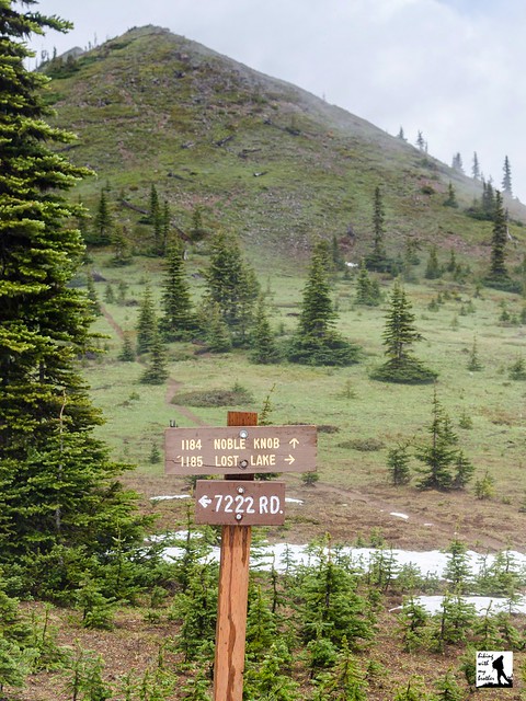
From the junction, head left following the ridgeline as the trail turns north paralleling the Norse Peak Wilderness to the west, ever so briefly entering it for a few moments before leaving it again. You’ll know you went through the Wilderness when you pass the junction with the Dalles Ridge Trail #1173 in about a mile. Stay on the Noble Knob Trail to the next junction in a tenth of a mile. Here the trail splits in three directions. The path to the right is the Lost Lake Trail #1185, leading into the Wilderness and to the shores of Lost Lake. The trail to the left heads out to the other end of the Noble Knob Trail as well as a side trail leading down to Twentyeight Mile Lake. To reach the summit, take the middle path straight up to the top.

As you climb, the views only improve. Catch glimpses of Lost Lake to the west, and Twentyeight Mile Lake to the east. There is some confusion around the name of this lake – some USGS maps label it Twentymile Lake. Most likely the product of a typographical error somewhere along the line, the official name for this little lake is Twentyeight Mile Lake. Before you know it you will have reached the top and its 360-degree views. Mt. Rainier seems almost close enough to touch. Look north for your first view of George Lake in the meadow-filled cirque below you. Forested peaks spread out in every direction. Find a good place to settle in and see how many peaks you can name.

This approach to Noble Knob is not for everyone. Where the Noble Knob Trail from Corral Pass involves only a modest 500 foot climb, the Deep Creek approach is a tough 3,600 foot slog. Unsurprisingly, most hikers opt for the easier approach, which makes this a great training hike or a good option if you’re looking for a little solitude on the trail. The Deep Creek Trail is also the winter approach to Noble Knob once the snows close off the forest roads leading up to Corral Pass.

To get there, take I-5 south to Highway 18, Exit 142A. Follow Highway 18 into Auburn and take the SR 164 exit. Head left on SR 164 through Enumclaw to SR 410. Head left onto SR 410 and continue 31.2 miles through the town of Greenwater to the Corral Pass Road #7174 on the left. The road is unpaved. Follow #7174 for 1 mile to the White River Trailhead and a small parking area on the left side of the road at the end of a switchback. -Nathan

Print Google Directions >>

Deep Creek

Second Beach

Our Hiking Time: 2h
Total Ascent: 250ft
Highest Point: 200ft
Total Distance: 4.0 miles
Location: N 47° 53.460, W 124° 37.638
Required Permit: None
Difficulty: Easy

Nathan's Photo
Earlier this year we spent a weekend wandering down the beaches near La Push. There are three distinct beaches, each hemmed in by rocky headlands. Little effort went into naming these isolated beaches, now known simply as First, Second and Third Beach, perhaps because these stunning seascapes need no further decoration. Of the three, Second Beach is often cited as the favorite, and after our hike down this wild section of the Olympic coast, we can see why.

The hike begins from the roadside trailhead, dipping past the Lonesome Creek Fish Hatchery and quickly crossing over the log bridge that spans the creek. The graveled trail is wide and well-maintained, a testament both to the tireless efforts of volunteers as well as the thousands of boots that trek down the trail every year. The fern-lined trail rises gently as it cuts through a mossy forest of spruce and hemlock. As the trail levels out and enters the Olympic National Park, the trees thin, giving you the first glimpses of the ocean below. From here the trail quickly works its way down the bluff, steeply descending down to the log-strewn beach.

Once you arrive take a few moments to find a quiet place take in the landscape. To the right, find the headland known as Quateata and the natural arch the waves have carved into the rock. Ahead is Crying Lady Rock, the largest of the seastacks in this area, collectively referred to as the Quillayute Needles. To the left, a little over a mile down the beach is Teahwhit Head, the other end of the beach. If it is low tide, there is a lot to explore, as the rocky shore will be riddled with tidepools. After you’ve had your fill of starfish and anemones, make the journey down to Teahwhit Head to find more rocky seastacks and another arch.

No trip to La Push is complete without taking the time to explore Second Beach. While the steep drop to the beach might be challenging for very young hikers, most folks should not have much difficulty navigating this short trail. A popular overnight destination in the summer, expect to see folks tucked into the forest just above the beach. And if you time your visit in the early spring or early fall, you may be lucky enough to catch the telltale spray of migrating whales on the horizon.

To get to there, take the Bainbridge Island ferry to Bainbridge Island. From the terminal, follow SR 305 for 13 miles to SR 3 North. Follow SR 3 to the Hood Canal Bridge, taking a left over the bridge onto State Route 104. Follow SR 104 as it merges onto US 101 and continue 35 miles to Port Angeles taking a left on Lincoln Street, which becomes US 101. Continue for about 54 miles to the junction to La Push Road, also known as SR 110. Turn right and continue on SR 110 for 7.8 miles to Mora Road. Veer left and continue another 2.3 miles to the trailhead and parking area on the left side of the road. -Nathan

Print Google Directions >>

Second Beach

Hope & Mig Lakes via Tunnel Creek Trail #1061

Our Hiking Time: 2h 10m
Total Ascent: 1500ft
Highest Point: 4700ft
Total Distance: 4.2 miles
Location: N 47° 42.263, W 121° 5.190
Required Permit: None
Difficulty: Moderate

Nathan's PhotoNot long ago we took advantage of a sunny summer afternoon to return to Stevens Pass and visit the Alpine Lakes Wilderness. We had our sights set on Hope and Mig Lakes, a diminutive pair of tarns tucked into mountaintop meadows. With the promise of picturesque lakes and a refreshing dunk in an alpine lake, we started up the trail in the heat of the day.

Unless they're following the Pacific Crest Trail, most hikers access Hope and Mig Lakes via the Tunnel Creek Trail #1061. Tunnel Creek was named for the nearby Burlington Northern Tunnel that was drilled beneath Stevens Pass. The story of the tunnel and the railroad route over the pass it replaced can be found in our Iron Goat Trail report. As for Hope and Mig Lakes, we have yet to dig up any background on their story.

The Tunnel Creek Trail #1061 begins by climbing up onto the shoulders of the mountainside into a mature forest of fir, hemlock and cedar. From the trailhead, the climbing never really stops until you reach Hope Lake, alternating between switchbacks and traversing ever upward. While some sections of trail have been improved, much of the route is rocky, narrow, and steep. As you press onward, talus fields offer occasional glimpses of the surrounding landscape and the valley below, while small streams cut across your path adding a little variety to your ascent. After about 1.5 miles cross into the Alpine Lakes Wilderness and not long after reach the shores of Hope Lake as the route joins the Pacific Crest Trail.

From Hope Lake, head left along the PCT, quickly leaving dense forest behind. Here the trees thin and yield to expanding meadows. If you’re heading up in the late spring or early summer, expect to see this area brimming with wildflowers and buzzing with bees. Later in the season you’ll find plenty of huckleberries. After .5 miles find yourself at Mig Lake, quietly nestled at the base of a small prominence. The lake’s shores are lined with an alluring mixture of grassy meadows and clusters of evergreens. Find a comfortable spot to settle down and enjoy this quiet and idyllic scene. Looking for more? Continue onward to find Swimming Deer Lake in about a mile and beyond that Josephine Lake at 4.3 miles from the trailhead.

Admittedly, Hope and Mig Lake are not the most stunning alpine lakes, but they still make for a pleasant visit. The Tunnel Creek Trail also has the advantage of being a little off the beaten path. While work is being done to improve the trail, there are still some rough and steep sections that keep the crowds away from this approach. Note that though you are unlikely to share the trail up to Hope Lake, the lakes themselves are more frequently visited by those hiking the PCT. Short and steep, this hike is perfect if you’re looking for something a little different or if you just want to fit in a quick conditioning hike.

To get there, take US 2 out to milepost 60. Just beyond the milepost, as the highway begins to turn sharply to the left, you will cross over Tunnel Creek and find FR 6095 on your right. Take a right, following FR 6095 1.2 miles to an intersection. Veer left and find the marked trailhead within a few hundred feet. -Nathan

Print Google Directions >>

Hope & Mig Lake

Old Mine Trail

Our Hiking Time: 1h 20m
Total Ascent: 300ft
Highest Point: 2200ft
Total Distance: 2.8 miles
Location: N 46° 59.586, W 121° 53.466
Required Permit: National Park Pass
Difficulty: Easy

Nathan's Photo
We’ve spent a lot of time in the Carbon River area this summer, visiting many of the more popular destinations such as Mowich Lake and the Carbon Glacier. Along the way, we also found a few short side trips like the Old Mine Trail that added a little taste of the mining history that helped shape the Carbon River we know today.

The Carbon River Valley has a long mining history, and around the turn of the last century, companies were pulling gold, silver and copper out of mines in the area. Following these successes, the Washington Mining and Milling Company staked 38 claims on the south side of the Carbon River beginning in 1906. In an effort to get more supplies to their claims, the company agreed to help build portions of what would eventually become the Carbon River Road. While the company christened their claims with hopeful names such as the Copper King Group, Gold Coin Group and Silver King Group, the exploratory adits they dug did not yield any significant finds. Low production and pressure from the Park Service led the company to cease operations in 1913.

While records are not complete, the Old Mine appears to be one of the company’s adits.  It extends about 165 feet back into the rock. In 1950 or 1951, a ranger named Aubrey L. Haines was told about a mine near the Carbon River Road. Based on the description, Haines was able to locate the Old Mine as well as a number of buildings and an inclined railway track. The buildings disappeared by the 1980s, and the tracks have since followed. Today only the entrance of the mine remains.

The hike begins at the gated Carbon River Entrance to Mt. Rainier National Park. Whether hiking or biking, follow the Carbon River Road for 1.2 miles to a small parking area and the signed Old Mine Trailhead. The trail plunges into the mixed forest and quickly begins to switchback steeply up the mountainside. After a few minutes of climbing, find yourself facing the gated mine entrance. Take a few minutes to explore the entrance and shine a light into the darkness. Once you’re rested up, head back down and continue on to your next destination.

While not much in the way of a hike, this quarter-mile detour from the Carbon River Road is an easy add-on to a day of hiking. Trail volunteers have recently upgraded the trail, making the short trek even easier. Easily accessible from the Carbon River Road,the Old Mine Trail is something any hiker can explore.

To get there, take I-5 South to I-405. From I-405 take SR 167 south toward Auburn. In 20 miles take the SR 410 Exit toward Sumner/Yakima. Follow SR 410 for 12 miles to SR 165. Take a right and continue on SR 165 for about 10 miles through Wilkeson and Carbonado to the Carbon River Road/Mowich Lake Road junction. Veer left onto the Carbon River Road and follow for 7.7 miles to the Carbon River Entrance of Mt. Rainer and parking. -Nathan

Print Google Directions >>
Old Mine Trail
Copyright 2008-2016 - hikingwithmybrother.com
hikingwithmybrother@gmail.com