about us | links | permit info
Subscribe to Hiking With My Brother Email Subscribe Follow Hiking With My Brother on Facebook Follow Hiking With My Brother on Twitter Hiking With My Brother Picasa Hiking With My Brother YouTube

Raging River Trail - Tiger Mountain

Our Hiking Time: 4h 15m
Total Ascent: 1200ft
Highest Point: 1800ft
Total Distance: 9.0 miles
Location: N 47° 29.0640, W 121° 52.3520
Required Permit: Discover Pass
Difficulty: Moderate

Nathan's Photo
A few weeks ago we decided to stay a little closer to home and visit a lesser known portion of the Tiger Mountain State Forest. While we had a vague idea that there was portion of the Forest around the Raging River, we found very little information on it. Thinking that we could share a little of what we found with our readers, we set out on our expedition.

While our hike was all within the Tiger Mountain State Forest, just across Highway 18 is the nearly 11,000-acre Raging River Forest that connects the Tiger Mountain State Forest with Rattlesnake Mountain Recreation Area and also contains the headwaters of the Raging River. The river is named for the large seasonal variation in the volume of water that sometimes “rages” past its banks, often causing flooding damage, most recently in 2006. The river is also an important habitat for Chinook salmon that eventually find their way into the Snoqualmie River. For decades Weyerhaeuser managed the Raging River Forest, before selling it to the Fruit Growers Supply Company in the late 1990s. During that time the Raging River Forest represented one of the largest gaps in the Mountains to Sound Greenway. After years of effort, the Washington Department of Resources and King County partnered to purchase the forest in May 2009.

Note: while the majority of our hike was on trails, a washout at Deep Creek required a log crossing and some bushwhacking to get back to the trail. This section of the hike should be approached with caution.

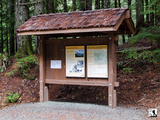
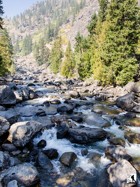
From the trailhead, the Raging River Trail leads into a clearing carved into the forest for the power lines crackling overhead. Here you can head right and take the short side trail down to the Raging River and walk under the bridge to the riverside.  Across the water, you'll see a trail that heads up through the Raging River Forest and eventually connects with the Rattlesnake Mountain Trail - but currently, there's no easy way to cross the river and access the trail.  So, after you’ve checked out the river, head back to the main trail and follow it a few tenths of a mile to Deep Creek. Along the way you’ll pass side trails snaking off into the woods. Avoid these, as they usually lead to private property.

Once you reach the washout at Deep Creek, follow a boot path down to the water and carefully make your way across the creek on a fallen log. Once across, find a faint path leading up into the forest, through some bramble and eventually back to the Raging River Trail under the power lines. Push up to the top of the rise to connect with the East Tiger Road 7000 (variously labeled on different maps as Road 7500, Road 7000 and Highway 18 Powerline). From here you have a choice. You can head left following the power lines to the Tiger Summit Trailhead, or head right deeper into the forest.

We recommend you head right and follow the East Tiger Road two miles to the Preston Railroad Trail. Along the way you will pass junctions for the Northwest Timber Trail and the Silent Swamp Trail. Skip the Northwest Timber Trail as it just heads out to the Tiger Summit Trailhead, but when the Silent Swamp Trail re-opens after trail construction is complete, it will be possible to make a short loop by following it up to the main road and then following it back down to the East Tiger Road. Once you reach the Preston Railroad Trail, you can follow it up to the summit of East Tiger and all its radio tower glory.

We don’t recommend this hike for everyone. This is more for those folks that have a sense of adventure and don’t mind a little bushwhacking and route finding. This is also a decent choice if you’re looking for a nearby hike that avoids the crowds. Until a bridge is built across either Deep Creek or the Raging River there is not much easily accessible from the Raging River Trailhead. However, if you can navigate the log spanning Deep Creek, you can explore portions of the Tiger Mountain State Forest usually seen only by mountain bikers. Or, if you don’t mind fording the Raging River, you could easily make a day out of climbing up the backside of Rattlesnake Mountain.

To get to East Tiger, take I-90 to Exit 25 Highway 18 junction. Take Highway 18 south for 1.5 miles to the Raging River Bridge. Cross the bridge and almost immediately take a right onto a blue-gated road. This unsigned area is the Raging River Trailhead and has enough room for about four cars. -Nathan

Print Google Directions >>

Raging River

Barlow Point Trail #709

Our Hiking Time: 1h 15m
Total Ascent: 850ft
Highest Point: 3200ft
Total Distance: 2.2 miles
Location: N 48° 2.2380, W 121° 26.5920
Required Permit: Northwest Forest Pass
Difficulty: Easy

Nathan's PhotoA few months ago, just before the snows closed the Mountain Loop Highway for the winter, we headed out to Barlow Pass to do a little exploring. While most hikers heading out to Barlow Pass have their sights set on Monte Cristo or Gothic Basin, we took a short jaunt up to Barlow Point, the site of a former fire lookout.

As we’ve mentioned in the past, prospector F.M. Headlee is credited with discovering Barlow Pass around 1891. Around the same time, the continued expansion of the Monte Cristo mines meant that a railroad was needed to transport ore to Everett for processing. The mining companies hired John Q. Barlow to survey the railroad route and the pass was named in his honor. For whatever reason, there are a number of publications that claim Barlow Pass was named after pioneer Samuel K. Barlow. While that is true for the Barlow Pass in Oregon, Washington’s Barlow Pass was named after the railroad surveyor.

The Everett and Monte Cristo Railroad ran right through Barlow Pass on its way to Monte Cristo. Mining companies built warehouses at the pass for storing supplies and the Forest Service built a guard station. Around 1916 a large forest fire cleared the trees from the ridge above Barlow Pass, and in 1935 a fire lookout was built on that ridge. Rangers working for the Forest Service would reside in the guard house and hike up to the fire tower when fire danger was high. The tower and guard station were removed in 1964.

The forested trail begins from the parking lot at Barlow Pass, the site of the Forest Service guard station. The first moss-lined section of trail is nearly flat, winding under the trees for a third of a mile before reaching the junction with the Old Government Trail #733. Veer right, following the sign pointing the way up toward Barlow Point. From here, the trail begins to steepen, switchbacking up toward the rocky ridgeline.

After climbing a little over 800 feet, you’ll find yourself at the remnants of the fire lookout. Nothing more than a few scraps of metal and cable remain. Although the trees have grown up to obscure the views, on a good clear day you can pick out quite a few peaks. Looking east over the South Fork Sauk River are the rocky cliffs of Sheep Mountain. To the north are Dickerman Mountain and Twin Peaks. Looking west over the South Fork Stillaguamish Valley is Big Four Mountain and Hall Peak. To the south find Lewis Peak and Silvertip Peak.

This short hike is probably best combined with a tour of the Old Government Trail #733, as together they make up enough trail time to justify the trek out to Barlow Pass. Although the trail to the lookout site is on the steep side, the short distance should make it a destination that almost every hiker can reach. And, because the narrow trail is well-maintained, it’s a good option for younger hikers. Next time you’re out at Barlow Pass, consider adding this short side-trip up to a former fire lookout.

To get there, take I-5 North to Exit 194. Follow Highway 2 for about two miles. Stay in the left lane and merge onto Lake Stevens Highway 204. Follow for two miles to Highway 9. Take the left onto Highway 9 toward Lake Stevens. In just under two miles, you’ll reach Highway 92 to Granite Falls. Take a right and follow for about nine miles to the Mountain Loop Highway. Take the MLH for 31 miles to Barlow Pass. Find the trailhead parking lot on your left. -Nathan

Print Google Directions >>

Barlow Point

Evans Creek Preserve Loop

Our Hiking Time: 1h
Total Ascent: 100ft
Highest Point: 200ft
Total Distance: 1.8 miles
Location: N 47° 38.5200, W 122° 2.6760
Required Permit: None
Difficulty: Easy

Nathan's Photo
During the off-season, when mountaintops and forest roads are still covered in snow, we will often go looking for some low-elevation alternatives. There are quite a few “hidden” parks, reserves, and recreation areas tucked into the Cascade foothills. Some have extensive trail systems that provide real hiking opportunities, others are smaller and their trails are ideal for shorter walks. A few weeks ago, we visited Evans Creek Preserve, one of those areas on the smaller end of the scale, and found more variety than we were expecting on this former farmstead.

Around 1900, Calvin and Minnie Galley settled on the land we now know as the Evans Creek Preserve, built a house, and started a farm. As the years passed the farm become home to their son, Newton Galley, and his wife Kathryn, who lived there until they passed away in the mid-1990s. After owning property for nearly 100 years, the Galley family willed it to their alma mater, the University of Washington, as well as Children’s Hospital, the Children’s Home Society, the Masonic Home, Redmond United Methodist Church and Whitman College. These organizations agreed to sell the farmstead to the City of Sammamish for $1.5 million in November of 2000. That sale began an 11-year effort that eventually resulted in the Evans Creek Preserve.

The city originally intended the 179-acre Preserve to have ball fields and other play spaces. But by 2002, the decision was made to protect and preserve the wetlands and forests contained within the property. The effort to convert the property from farmstead to preserve involved over 400 workers and volunteers, thousands of hours of work and at least one deployment of 50 goats to clear vegetation. The Washington Trails Association contributed 250 volunteers who put in over 7000 hours building the two and a half mile trail system. The buildings from the farmstead had to be torn down and removed, including the house built by Calvin Galley in 1900. By 2011, the work was complete and the Evans Creek Preserve opened to the public on October 22 of that year.

From the parking lot, the trail heads over a creek and branches off through meadows and into wetlands and mixed forest. The interconnected trail system is a series of loops complete with small bridges, viewing platforms, and an extensive boardwalk. Take a slow stroll through the varied landscape, enjoy the occasional view and, if you’re lucky, spot some wildlife. Although Evans Creek Preserve isn’t the rugged outdoors, it is a decent alternative for those looking for something different. The new trails are perfect for trail running, walking the dog, or just spending a little time outside. The ADA-accessible sections of the trail will also support strollers as well, making this perfect choice for introducing a little one to the great outdoors.

To get there, take SR 520 to the Redmond Way exit (SR 202). Veer right and merge onto SR 202 (also known as the Redmond-Fall City Road). Follow SR 202 for about three and a half miles to 224th Ave NE. Turn right and find a small parking area a short way down the road. Note that there is also a sign at the intersection of SR 202 and 224th indicating that NE 34th, a private road, begins at the end of 224th. -Nathan

Print Google Directions >>

Evans Creek Preserve

Snow Lakes Trail #1553 to Enchantment Lakes

Our Hiking Time: 9h
Total Ascent: 4200ft
Highest Point: 5500ft
Total Distance: 13.6 miles
Location: N 47° 29.1540, W 120° 44.9100
Required Permit: Northwest Forest Pass, Enchantments Permit for overnight stays
Difficulty: Hard

Nathan's PhotoOne of our backpacking excursions last fall took us into the Alpine Lakes Wilderness and up to The Enchantments. While we have backpacked through the region before, this was the first time we have been able to experience the fall colors and the changing of the seasons. Our approach took us up to Snow Lakes, a popular stopover point for those heading up to the Enchantments Basin.

Back in the 1930s the construction of the Grand Coulee Dam had an immediate impact on salmon runs. The Bureau of Land Reclamation worked to solve the issue through fish hatcheries, one of which was built on Icicle Creek to release into the Wenatchee River below the dam. Unfortunately, the Bureau quickly realized that fluctuations in the water levels of Icicle Creek would cause problems for a sustainable hatchery. The problem was a lack of cold water; the solution was to tap the nearby Snow Lakes seven miles upstream.

In 1938 the Forest Service cut a trail up to Nada Lake and the Snow Lakes and a base camp was established on Nada Lake. From 1939-1942 crews worked to drive a 9-foot wide, 2,250-foot long tunnel through solid granite under Lower Snow Lake to the bottom of Upper Snow Lake. At the same time, a small dam was constructed to regulate the water levels between the upper and lower lake. Today, water drains from the bottom of the 150-foot deep Upper Snow Lake to a bulkhead where it is funneled into a pipe and shot out toward Nada Lake. A series of valves controls the amount of water discharged. On average the system is in operation 77 days a year, usually between July and October, and releases an average of 3,700 acre-feet of water.

The hike to Snow Lakes begins from the parking lot by following a maintenance road over Icicle Creek and past concrete canals. From the road the trail begins a slow switchback up into the sloping canyon. As you climb, evidence of the fires that ravaged the area in 1994 can still be seen. The skeletons of charred trees line the trail, though after nearly 20 years the underbrush has obscured much of the damage. However, the underbrush has yet to grow up enough to provide much in the way of shade, so this first section of the hike has a lot of sun exposure, making it hot and dusty during the summer.

As you leave the burn area and the faint smell of ash behind, the trail enters a pine forest and bends closer to Snow Creek, providing access to occasional creekside rest stops. Around the two mile mark the trail meanders past large cliff faces that are frequented by rock climbers and soon begins to veer up the rocky canyon slopes. Continue another two miles through talus fields, scattered sections of forest and brush-lined sections of trail to the sturdy footbridge crossing Snow Creek. Soon find yourself sharing the trail with Nada Creek as you push up to the marshy end of Nada Lake. While most hikers press onward to Snow Lakes on their quest to reach the Enchantments Basin, some choose to overnight in the quiet solitude of Nada Lake. Several campsites line the lower section of the lake. If nothing else, the shores of Nada Lake are an excellent resting point to recharge for the final push to Snow Lakes a mile and a half up the trail.

Continuing onward, the trail quickly and steeply rises up the slopes above Nada Lake. If water is being released from Snow Lake, you will see the spray gushing from the cliffs above Nada Lake. As you get closer, at a switchback in the trail, a bootpath leads out to the tunnel and the control valves for the drainage system. Push upward through rocky terrain to the relief of the forests that surround Snow Lakes. The trail leads across the small dam that controls the water level between the lakes. Depending on the time of year, Upper Snow Lake may be quite low, exposing sandy shores covered in the bleached wood of fallen trees. The craggy heights of The Temple rise dramatically above Upper Snow Lake creating a scene that epitomizes the Alpine Lakes Wilderness. Many campsites can be found around both lakes.

Snow Lakes is a decent backpacking destination unto itself, though most folks undertake the dusty trek with the intent of pushing upward into the Enchantments Basin. Because permits to overnight in the core Enchantments Zone can be hard to come by, the Snow Lakes make a perfect base camp for day hiking the area by using the more easily obtained overnight Snow Lakes Permit. Somewhat challenging, this trip is best taken in the company of those with at least some wilderness and backpacking experience. It can be done as a long day hike, though we recommend against it. The difficulty of the trail on a hot summer day combined with the chance that Upper Snow Lake could be low and somewhat less than majestic probably makes this a little too much effort for one day. Save this one for a short overnight or as part of your exploration of the Enchantments Basin.

To get there, take US 2 to Leavenworth. Just before you enter town, take a right onto Icicle Creek Road (FR 76). Follow Icicle Creek Road for just over four miles to a large parking lot on your left. Park and find the trailhead at the far end of the lot. -Nathan

Print Google Directions >>

Snow Lakes
Copyright 2008-2016 - hikingwithmybrother.com
hikingwithmybrother@gmail.com