about us | links | permit info
Subscribe to Hiking With My Brother Email Subscribe Follow Hiking With My Brother on Facebook Follow Hiking With My Brother on Twitter Hiking With My Brother Picasa Hiking With My Brother YouTube

Scout Lake Trail

Our Hiking Time: 2h 20m
Total Ascent: 900ft
Highest Point: 3900ft
Total Distance: 3 miles
Location: N 47° 21.1980, W 121° 29.7420
Required Permit: None
Difficulty: Moderate

Nathan's PhotoSometimes, all you’re looking for in a hike is to feel like you’ve gotten away from civilization to have some quality time with Mother Nature. Other times you need a hike to take friends and family that might not be interested in bushwhacking up a mountainside. Luckily, Scout Lake is the perfect answer to either of these needs: short, approachable, and reasonably rewarding.

Presumably, like a number of other lakes in Washington and scout lake hikingwithmybrotheraround the country, Scout Lake was named for the Boy Scouts that frequented its shores back in the day. It may still be a popular destination for various local troops, but we never spied any uniforms among the few tents we saw camped at the lake.

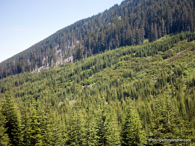
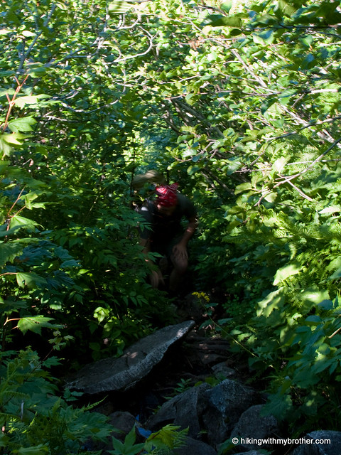
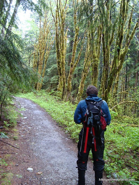
The short trail begins along a spur road off Hansen Creek Road (FR 5510). Follow the logging road for about a half-mile to the actual trail, which roughly follows a tributary of Hansen Creek up to Scout Lake. While occasionally narrow and a touch overgrown, the trail is generally easy to follow and not too steep. At one point, a washout creates some confusion as the trail seems to diverge in different directions – but either route will re-connect with the trail if you keep a sharp eye out for it. When in doubt, backtrack and you’ll soon be on the right path. During the summer, skipping across the creek over rocks and log bridges was a snap, though with heavier flow or icy conditions it could easily become more challenging.

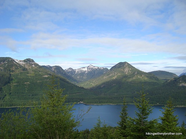
Scout Lake is tucked into a cirque below Humpback Mountain and Bearscout Peak. The quiet, talus-lined bowl and flat lakeshore make for great camping, and we saw some evidence that the fish were biting as well. Find a quiet spot on the shore and enjoy a taste of nature. Not tired yet? Never fear. From here, it’s easy for the hardened hiker to extend the trip up the ridge to the top of Humpback or find your way down to Annette Lake.

scout lake hikingwithmybrotherThis is a fun little trail to take just about anyone on, just rough enough around the edges to seem like an adventure. Although the short jaunt along a rocky logging road is nothing special, once you get into the woods, the surroundings are pleasant and inviting. As an added bonus, the lake is a little off the radar and we didn’t see any other hikers along the way, just a few backpackers at the lake. The lack of company only adds to the lake’s secluded feel. All and all, we recommend this little hike that has a little something for everyone.

To get there, take Exit 47 off I-90 and take a right over the bridge. At the intersection, turn right onto Tinkham Road (aka Forest Road 55). Continue for roughly a mile to a fork and veer left onto the Hansen Creek Road (aka Forest Road 5510). Follow the road under the old railroad trestle and up two switchbacks. Continue up for another half-mile or so past a locked yellow gate to an unmarked road that intersects FR 5510. Find a spot to park along the road and follow the spur uphill. -Nathan

Scout Lake

Snoqualmie Mountain Trail

Our Hiking Time: 6h
Total Ascent: 3100ft
Highest Point: 6278ft
Total Distance: 3 miles
Location: N 47° 27.5340, W 121° 24.9900
Required Permit: Northwest Forest Pass
Difficulty: Hard

Nathan's PhotoA gorgeous day demanded that we find a high perch to survey the landscape. Luckily, we had just the hike in mind, a summit that we’d noticed on our way up Guye Peak: Snoqualmie Mountain.

snoqualmie mountain hikingwithmybrother


We highly recommend this hike for those that are up for a little punishment. We definitely met some folks on the trail, but they were a tiny percentage of the hikers clogging the parking lot bound for Snow Lake. There is plenty of room at the top to find a place to settle down, argue about the names of peaks, and enjoy a hard-earned lunch.

There's a lot more to Snoqualmie Mountain, and you can learn all about it in our book, Hiking Through History Washington.  You'll find a trail map, route descriptions, history, and more for this and many more hikes throughout the State. Help support hikingwithmybrother.com and the work we do by picking up a copy!

To get there, take I-90 to exit 52. From the exit, take a left onto Alpental Road for about two miles to a large gravel parking lot. The dirt road is across the road to the right, near the Snow Lake trailhead. -Nathan

Print Google Directions >>

Snoqualmie Mountain

Gold Creek Trail #1314 to Alaska Lake

Our Hiking Time: 7h
Total Ascent: 1700ft
Highest Point: 4200ft
Total Distance: 11.5 miles
Location: N 47° 27.5100, W 121° 21.1620
Required Permit: Northwest Forest Pass
Difficulty: Hard

Nathan's PhotoGold Creek is one of the most popular snowshoe routes in Snoqualmie Pass, attracting thousands of snowshoe-clad hikers every year. Now that the snow has finally made its last curtain call of the season, we decided it would be a perfect time to explore Gold Creek Valley.

The Gold Creek Trail #1314 started out in 1898 as a prospecting trail gold creek alaska lake alta mountain hikingwithmybrotherfollowing the creek to various claims along the ridges of the valley. As times changed and mining gave way to recreation, the trail deteriorated and all but disappeared from neglect. In the 1970s, the Forest Service rescued the route and for the next 30 years, snowshoers and hikers enjoyed the gentle trip through the valley. In 2002, large swaths of the trail were destroyed by a massive avalanche that tumbled down one side of the valley and splashed up the other side, leaving thousands of downed trees in its wake. Today, the Forest Service and volunteers have craved something of trail out of the debris, but portions remain a challenge to navigate.

The trail begins along the Gold Creek Pond Trail, a stroller-friendly asphalt loop around Gold Creek Pond. Signs quickly direct you off the pavement and onto a series of private roads that meander for about a mile before you reach actual trail. Once on the trail, things are fairly level and pleasant, Gold Creek keeps you company for the first two miles as you travel through thimbleberry and vine maple, which slowly yield to hemlock and cedar. A little over two miles into the trail, just after you enter the Alpine Lakes Wilderness, you’ll reach the 2002 avalanche area; an abrupt wasteland of rocks and fallen logs. On the plus side, the avalanche stripped the vegetation from the cliffs above and exposed a few small waterfalls that tumble down the rocks to meet up with Gold Creek.

gold creek alaska lake hikingwithmybrotherAfter you navigate the avalanche area, you’ll need to ford Gold Creek. Later in the season, when the water is low, the crossing can be down without getting your feet wet. When we did it we were up past our knees in the icy water, but it was not nearly as difficult for us as Sunday Creek. Once across the trail continues for another mile and two more creek crossings before “ending” with a sign pointing you toward to Alaska and Joe Lakes while glibly stating, “trail not maintained beyond this point.” They’re not kidding.

The rocky trek up to Alaska Lake is only a mile, but demands a thousand feet of elevation gain. The bootpath follows Alaska Creek through groves of slide alder and vine maple to the shores of Alaska Lake, alternating between climbing up abandoned creekbeds and clambering over fields of talus. It is not an easy trek, but Alaska Creek is little more than one long waterfall cascade, and the views of Gold Creek valley and Alta Mountain alone are worth the attempt. Alaska Lake itself is a nice little destination, tucked beneath Alaska Mountain and the Pacific Crest Trail, with a couple of nice campsites along the lakeshore. For those looking for the extra adventure, push onto the PCT for an alternative approach to Joe Lake, rather than the bushwhack-heavy route below.

Aside from the creek crossing and the avalanche area, thisgold creek alaska lake hikingwithmybrother trail is a pleasant stroll to the Alaska Lake junction. For those looking for an easy hike with a bit of distance, hiking to the junction and back is an approachable ten-mile jaunt. The trip up to Alaska Lake, however, is challenging but ultimately rewarding, well worth the slog up the mountainside. Between the paved Gold Creek Pond trail and the rugged Alaska Lake scramble, there is something for everyone on this hike.

To get there, take I-90 to the Hyak Exit 54 and take a left. After you pass under the freeway, take a right on the frontage road, Forest Service Road 4832. Follow the road for approximately 1.5 miles to the signed Gold Creek Road, Forest Service Road #142. Turn left and follow the road for a half-mile to the Gold Creek Pond parking lot and trailhead. - Nathan

Gold Creek & Alaska Lake

Lake Lillian & Mt. Margaret Trail #1332

Our Hiking Time: 5h
Total Ascent: Lake Lillian 1040ft; Full trip 2200ft
Highest Point: Lake Lillian 4800ft; Mt. Margaret 5560ft
Total Distance: Lake Lillian 1.75 miles; Full trip 5.3 miles
Location: Lake Lillian N 47° 23.9460, W 121° 20.3700 Mt. Margaret N 47° 22.9920, W 121° 20.3580
Required Permit: None
Difficulty: Hard


Nathan's PhotoWe’re always looking for ways to extend a hike to nearby peaks and lakes. Often, when trying to dig up more information on a hike, we’ll stumble across new trailheads and alternative approaches. This is exactly what happened when we were contemplating a climb to the top of Mt. Margaret –margaret lillian hikingwithmybrother a trip that would require re-hiking the Lake Lillian Trail #1332. Instead, we found an unofficial “shortcut” trail to Lake Lillian, which allowed us to access the mountaintop from an entirely different direction with less mileage. Happy to be breaking new ground, we packed up and headed out to Hyak.

Unsurprisingly, the unofficial trail is rough and haphazardly scraped into the mountainside. The steep half-mile to Lake Laura and the main trail follows Rocky Run Creek past slide alders, devil’s club and the occasional hemlock. The creek sports a couple of impressive cascades that are easily accessed and worth the short diversion. As the trail briefly plateaus, a spur leads down the few hundred yards to Lake Laura. Access to the lakeshore is limited, but clambering on the rocky cliffs for a better view of the waterfall were enough to tempt us down to the water.

Whether you take the side trip down to Laura or not, the path quickly connects with the Lake Lillian Trail. From here, you have a choice; push up the short distance to Lake Lillian or head right toward Mt. Margaret. The placid waters of Lake Lillian sit beneath Rampart Ridge, quietly margaret lillian hikingwithmybrotherfueling Rocky Run Creek. It is possible to skirt the edge of the lake and slog up the ridge to Rampart Lakes and on to Alta Mountain. However, when the lake is high from snowmelt, the shoreline is fairly steep and requires some careful footwork to get around.

If the sun is shining and you’d like a view, head up to Mt. Margaret. Now on a refreshingly well-maintained official trail, the hike becomes easier. In a half-mile you’ll hike past Twin Lakes and look up to the rocky top of Mt. Margaret. From here, begin switchbacking up the shoulders of Margaret until the trail levels out and begins to traverse along the mountainside. Keep an eye out for a faint spur trail following a ridge to the summit and follow it to the top. Once there, find Laura, Lillian and Twin Lakes on display below. On the other side, Margaret Lake sits at the base of the mountain, with Stonesthrow Lake a little further beyond. Sit back and enjoy the quiet.

This is a fun little approach to Lillian, which is a nine-mile hike from the official trailhead. It’s on the more difficult side, but it is a great alternative to the more popular route. If you’re going purely for Mt. Margaret, the official approach is probably more efficient, margaret lillian hikingwithmybrotherbut includes walking along gravel logging roads and lengthy stretches through recent clear-cuts. Although the road to the shortcut trailhead is currently a bit overgrown, the scenery is much more pleasant from this approach. You’re also unlikely to run into too many other people, as most hikers opt for the traditional trailhead.

To get there, take I-90 to the Hyak Exit 54 and take a left. As you pass under the freeway take a right on the frontage road. Follow the road for about two and half miles before it becomes the graveled Forest Service Road No. 4832. Follow FR 4832 for a mile or so to an intersection. Head left onto an unmarked road, labeled FR 136 on maps. Follow the increasingly overgrown FR 136 for about two miles until you get to a major switchback and a small parking area. - Nathan

Lake Lillian & Mt. Margaret

Sunday Creek and Sunday Lake Trail #1000

Our Hiking Time: 4h 30m
Total Ascent: 330ft
Highest Point: 1900ft
Total Distance: 6.5 miles
Location: N 47° 37.6080, W 121° 34.9200
Required Permit: Hancock Recreation Pass
Difficulty: Hard

Nathan's PhotoWe’ve yet to really explore the North Fork Snoqualmie River Valley. Much of our hesitation had to do with road closures that block access to some of the more interesting hikes. But, when we learned that the Sunday Creek Bridge was scheduled to re-open this summer, we decided to check out one of the westernmost lakes in the Alpine Lakes Wilderness Area: Sunday Lake.

The much lamented and often-maligned Sunday Lake Trail #1000 sunday lake trail hikingwithmybrothercould be more of a stroll than a hike – with little elevation gain on the three-mile trek to the lakeshore, it would be perfect for fledgling hikers or a family outing. Sadly, this is not the case. A number of factors work to make this trail unexpectedly more difficult to find and successfully hike, putting it into a category best reserved for more experienced hikers.

The first challenge is finding the unmarked trailhead, about 14 rough miles down Forest Road #57. Start looking to the right for a gate labeled “Gate 30,” about a mile after you cross Sunday Creek. Once you’ve found an unobtrusive place to wedge your vehicle, start down the brush-lined logging road. Within a mile, your next challenge appears – a marsh has long since reclaimed the road. Over the years, volunteers and resourceful hikers have laid down logs, rocks, and hunks of wood to help with the crossing. The water level and number of pestering insects vary throughout the year, but expect a little of both as you tip-toe through the muck.

Once past the swamp, follow the trail past clear-cuts and into the sheltering forest winding beneath rocky cliffs. At just over a mile there is a junction leading up to Loch Katrine to the right, but it is so overgrown you’ll have no trouble staying to the left to Sunday Creek. The creek can be the most difficult obstacle on this hike. Floods have long since washed away the bridge and portions of the trail along the riverside. Depending on the time of year, the crossing may be relatively easy, or may require a thigh-deep fording. With snowmelt swelling the creek, we spent some time looking for the best place to cross safely and only with a bit of luck did we avoid a plunge.

Once across, you’ll need to find the roadbed again. Depending on where you chose to cross, this could require some backtracking. The trail is tagged through the washout, making it relatively easy to find. However, when in doubt, follow the creek. Hike past the rusting remains of logging activity through the forest as it slowly changes into the older growth associated with the Alpine Lakes Wilderness. Blowdowns and overgrowth are more of an issue along this final leg to the lake, though it is clear a few dedicated individuals are waging a private war against the encroaching forest. After three miles the first indications of the lake appear, the first marshy sections of what will eventually become Sunday Lake. As you hike along the lakeshore, the trail continues to worsen, becoming more rocky and narrow with no real access to the water. In better days, the trail continued up to Mowitch and Honey Lakes, but the old bootpath is now extremely overgrown and difficult to follow. Sunday Lake’s tree-covered shores make asunday lake hikingwithmybrother full view of the landscape difficult, but we found the best bet to be at the base of the lake, where the marshes yield to open water. From here logs offer a nice spot to have a snack and take in Goat Mountain and the waterfalls streaming off it. Sunday Lake is a mixed bag. On the one hand, there are nice stretches of old growth forest, a healthy dose of adventure, and plenty of quiet solitude. On the other hand, it’s a great deal of effort for a marshy lake. Perhaps in combination with Lake Phillipa or Loch Katrine this would be a more satisfying hike, but as it stands, Sunday Lake is difficult destination to recommend. Then again, the lake is reported to be a good place to fish, and could be a decent base camp for exploring nearby peaks and lakes. To get there, take I-90 to exit #31, taking a left into North Bend. After the outlet malls, take a right on North Bend Way and an almost immediate left onto Ballarat Street. After four miles the road splits, veer left onto the North Fork County Road (Forest Road #57). Continue a little over 14.5 miles to Road #5720 and Gate 30. -Nathan Sunday Lake

Lake Dorothy Trail #1072

Our Hiking Time: 3h 30m
Total Ascent: 900ft
Highest Point: 3100ft
Total Distance: 7.2 miles
Location: N 47° 35.1000, W 121° 23.0640
Required Permit: Northwest Forest Pass
Difficulty: Easy

Nathan's PhotoThis week, another rainy day steered us toward the ever-popular Dorothy Lake Trail, typically awash in hiking traffic. The lake’s popularity is a combination of easy access and sheer size – there is a lot of room to play on Dorothy’s two-mile long lakeshore. Thinking the rain would keep the crowds to a minimum we packed up and headed out to Highway 2.

dorothy lake camp robber creek hikingwithmybrotherUnfortunately, we couldn’t find out the origin of the lake’s name, although we know it was christened sometime back in the 1800s. Most of the lore we could find centers around the previously described Dorothy Lake Highway Project that spurred the creation of the Alpine Lakes Wilderness. Today, all that remains of that dream is the Dorothy Lake Trail #1072, which still traces the proposed route.

The trail begins easily, following the East Fork Miller River for a little over a half-mile until Camp Robber Creek joins it. Take a moment at the bridge to enjoy the rushing water before plunging back into the old growth forest. The trail steepens once across the bridge, but stairs, elaborate boardwalks, and countless volunteer hours have tamed the once-rocky trail. Thousands of boots also keep the trail wide and extremely well maintained. At scarcely a mile-and-a-half a junction points you to the log-filled lake outlet and a view of the narrow lake with Big Snow Mountain in the distance. The trail then continues along the entire length of the lake and then over a ridge to Bear, Deer, and Snoqualmie Lakes, eventually connecting with the Snoqualmie Lake Trail #1002.

Short and rewarding, this hike is perfect for kids, families, and getting those non-hiking friends on the trail. While Dorothy Lake isn’t the largest lake in the Alpine Lakes Wilderness, it’s a dorothy lake hikingwithmybrothercontender, and it’s sure to impress. Small islands dot the lake surface and private nooks and coves abound, making it easy to find a good place for a break. For those looking for a longer day, continue around the far end of the lake and over the ridge to Deer, Bear, and Snoqualmie Lakes -- the extra effort putting you well beyond the reach of the crowds. Although rain and lingering snow kept us from continuing up the ridge to the other lakes, we’ll be back to explore them before long.

To get there, take Highway 2 out to the Old Cascade Highway, located between milepost 45 and 46. Take the Old Cascade Highway out toward the Money Creek Campground, crossing the railroad tracks and continuing for a mile before turning right onto the Miller River Road (Forest Road #6410). Follow this road 9.5 miles until it ends. Confusingly, the road number changes to #6412 at roughly 4 miles – ignore this and continue onward to the trailhead. -Nathan

Dorothy Lake

Marten Lake Trail #1006

Our Hiking Time: 5h 15m
Total Ascent: 1800ft
Highest Point: 3000ft
Total Distance: 8 miles
Location: N 47° 35.6040, W 121° 30.6000
Required Permit: Northwest Forest Pass
Difficulty: Hard

Nathan's PhotoOccasionally, we’ll plan a hike and afterward find that we overlooked an interesting side trip. Such was the case with Marten Lake, a lesser-known hike near Otter Falls. Despite some rain, we packed up and headed back to the Middle Fork Snoqualmie Valley to do some bushwhacking.

Today the trail to Marten Lake is largely abandoned, and although named for the pine martens once prevalent in the area, fishing now seems to be the main attraction. Knowing things would be a bit overgrown, we brought along some clippers to reign in the vegetation and clear out some blowdowns. Our work opened up a bit trail and made the hike marten lake hikingwithmybrotherback from the lake a lot easier.

Like Otter Falls, the Marten Lake Trail #1006 is an unmarked spur off the Snoqualmie Lake Trail #1002. Occasionally rock cairns or tags mark the trailhead, but there is no guarantee that these will be present. Instead, just keep an eye out for the bridge spanning Marten Creek a little over two miles down the trail, the first major bridge along the trail. You should not cross the bridge – the trailhead is about 100ft before it. Unfortunately, because the trailhead is unmarked, there are dozens of paths branching off the Snoqualmie Lake Trail, which adds to the confusion. When in doubt, pick one and head up, following the creek. Eventually, the trail will appear.

The steep and narrow path hugs Marten Creek through old growth forest for about a half-mile before spilling out into an open brush-filled canyon. The trail is fairly level here, and if the weather is good it’s possible to catch glimpses of the Middle Fork landscape below. The last quarter-mile of the trail is perhaps the roughest, as you crawl out of the alders and blueberries and switchback into forest. The water can make the route difficult to navigate, though the encroaching undergrowth often lends a helping hand to keep you on the trail. Eventually, you will reach the lake and the trail diverges into smaller paths snaking around the lakeshore. Do some exploring and find a good place for lunch.

marten lake hikingwithmybrotherThe landscape is impressive –Marten Lake lies in a large cirque at the base of the looming Rooster Mountain. Additionally, the area is quiet and isolated, making it a wonderful place to relax on a sunny day. On the down side, the short trail to the lake is rough and difficult to follow, putting it out of reach for more causal hikers. Still, the route does offer some good access to waterfalls along Marten Creek and the occasional view of Treen Peak and Mt. Garfield. While difficult, this is a great hike if you are looking to escape the crowds and see something off the beaten path.

To get there, take Exit 34 off I-90 and take a left on 468th Ave. Follow the road past the truck stop for about a half-mile until you reach SE Middle Fork Road, also known as Forest Road 56. Take a right and continue to follow the twists in the road until the pavement runs out. Continue on FR 56 for 12 miles, crossing the Taylor River. Once across, keep to the left for another quarter mile to the end of the road and the Snoqualmie Lake Trailhead. -Nathan

Marten Lake
Copyright 2008-2016 - hikingwithmybrother.com
hikingwithmybrother@gmail.com