about us | links | permit info
Subscribe to Hiking With My Brother Email Subscribe Follow Hiking With My Brother on Facebook Follow Hiking With My Brother on Twitter Hiking With My Brother Picasa Hiking With My Brother YouTube

Index Town Wall Overlook

Our Hiking Time: 2h
Total Ascent: 1300ft
Highest Point: 1800ft
Total Distance: 2.5 miles
Location: N 47° 49.4100, W 121° 34.0380
Required Permit: None
Difficulty: Hard

Nathan's PhotoWe continued our exploration of the Index area this week by checking out the iconic Index Town Wall. We had viewed these exposed cliff faces from Heybrook Lookout and Bridal Veil Falls, and this time we decided to see if we could find a way to the top. With a little bushwhacking and some inventive route finding, we eventually came up with the best approach to access the cliffs.

This is a fun little hike, good for a day when you don’t have index town wall baring mountain gunn peak hikingwithmybrothera lot of time, with some great rewards on a short, if somewhat challenging, route. There is more to see and explore in the 1300-acre Forks of the Sky State Park for those that want to do a little extra. Obviously, use caution while up on the cliffs. It’s a 500’ foot sheer drop to the bottom. This area is extremely popular climbing spot, so be aware that there are likely climbers below.

There's a lot more to Index Town Wall, and you can learn all about it in our book, Hiking Through History Washington.  You'll find a trail map, route descriptions, history, and more for this and many more hikes throughout the State. Help support hikingwithmybrother.com and the work we do by picking up a copy!


To get there, take Highway 2 to the Index turnoff near Milepost 34. Follow the Index-Galena Road for about a mile to the bridge. Take a left across the river, proceeding through town to Index Ave.  Take a left crossing the railroad tracks and following Index Ave as it turns left and becomes 2nd Street.  Take the next left onto Avenue A and follow it out of out of town for a half mile to find the parking area on the right. Park and hit the trail. -Nathan

Print Google Directions >>

Index Town Wall

Mineral City - Silver Creek

Our Hiking Time: 8h
Total Ascent: 1400ft
Highest Point: 2200ft
Total Distance: 15 miles
Location: N 47° 57.0480, W 121° 25.9753
Required Permit: None
Difficulty: Hard

Nathan's PhotoAfter an aborted attempt to visit the Mineral City town site a few months back, we searched for more information on the hike. Recently, armed with better knowledge and plenty of time, we returned to the Index-Galena Road washout and began exploring.

It’s not clear exactly when Mineral City came into existence – it began as a collection of mining claims sometime in the 1870s. Back then, miners and prospectors were exploring the Silver Creek area for gold, silver, or anything else they could dig up and sell for a profit to the burgeoning industries in nearby Everett and Seattle. Before it was known as Mineral City, the mining camp was called Silver City, which is listed as existing as far back as mineral city silver creek hikingwithmybrother1880. In 1882, a road was cut to the nearby Galena, which, in turn, led to increased traffic to Mineral City, and probably made it possible for Joseph L. Pearsall to get there. By 1889, Pearsall was living in Mineral City, and he filed the Monte Cristo claims that same year. His early successes there quickly created a gold rush. Thus fueled by the rush, Mineral City grew, and by 1890 the town plan included 15 city blocks.

Inevitably, the wealth of Monte Cristo ran dry and other claims in Mineral City stayed small. Despite boasting two hotels, saloons and something of a population, the town began to slump. In 1914, a storm destroyed the Galena-Mineral City road, which was not rebuilt until 1929, and effectively killed the community. Over time, floods washed away virtually all traces of the former mining town. In the 1970s the Galena-Mineral City Road was expanded to access timber in the Silver Creek Valley, destabilizing the mountainside, and in 1980 nearly a quarter-mile section of the road slid down into Silver Creek. It was never rebuilt.

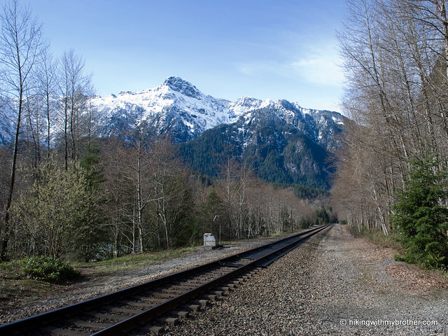
Today, one can hike to the town site along this same road, which is largely still intact. However, in what seems to be a running theme for this area, floods in 2006 washed out large sections the Index-Galena Road, making it much more difficult to access the hike. Now, instead of driving to Galena, one must either park at the washout, or drive all the way around and access Galena via Jack Pass on miles upon miles of forest road.

ineral city silver creek hikingwithmybrotherWe chose to navigate the washout by way of a trail that has been built to accommodate property owners who have been cut off since the 2006 storm. The trail begins where the road ends and is heavily marked. More than once the trail returns you to sections of asphalt that are still intact. The trail can be muddy and has some ups and downs to it, but it is not so bad that if we had it to do over again, we couldn’t haul some bikes over the trail so we could breeze over the miles of road on the way into Galena.

Once you reach the bridge, cross the river and veer right onto an unsigned road. After about a mile, you’ll hit a fork in the road and a rocky barricade. Ignore the road heading up hill and push on to the barricade. Not far beyond is the 1980 washout. The large swath of missing mountainside looks more intimidating than it is – although the rock is somewhat loose, much of it has been compacted by use, and shouldn’t pose too much of a problem for most hikers. The road is fairly easy to follow after this point, though various ravines have lost their bridges, and makeshift replacements are not always available – more than once one is forced to clamber down the edge of a gully and poke around for the best way back up.

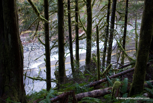
Despite the added effort, the trail is more than worth it. Silver Creek is your constant companion as you cross mammoth bridges built to hold fully loaded logging rigs. Waterfalls are abundant as creeks and streams filter down from the hills above. You’ll pass a number of adits – horizontal mines cut straight back into the rock – as well as a number of mining claims, not to mention a crumbling bus and large cabin with a sign cautioning hikers of a wounded bear.

Eventually you’ll reach the outskirts of the town site, marked by the words “Mineral City” chainsawed into a log. There is almost nothing here. Poke around and you may find the tree with the word “Mill” carved into it marking the location of the Mineral City mill. A large open area, some scattered stones and a few piled logs – more likely from timber works of the ‘70s than remains of Mineral City’s heyday – are all that suggest human activity. From here, you can catch glimpses of Sheep Gap Mountain and Silver Tip Peak to the north and Hubbart Peak to the east. Crested Butte is to the northwest.

For more adventure, cross the creek and continue on the road. Shortly, you’ll be find the single log that spans Silver Creek, and beyond still more sections of Mineral City – now only large swaths of leveled ground filled with young forest. The road begineral city silver creek hikingwithmybrotherins to degrade at this point, but the stalwart can bushwhack their way up to Poodle Dog Pass and down into the Monte Cristo Basin.

This is a great hike, with a lot to see and do along the way. Remote, scenic, not too strenuous, and, thanks to the washout of the Index-Galena Road, unlikely to include much company. The washout does add about five miles to the overall hike, making it much more of an undertaking than it will be when the road has been repaired. But, if you have the time, take a trip out to Mineral City and take a hike through history.

To get there, take Highway 2 to the Index turnoff. Drive past Index and continue on the Index-Galena Road until it ends a little over six miles from Highway 2. Park and find the trail up the hillside trail nearby. -Nathan

Mineral City

Putrid Pete's Peak - West Defiance

Our Hiking Time: 4h 15m
Total Ascent: 3000ft
Highest Point: 5220ft
Total Distance: 5 miles
Location: N 47° 26.3580, W 121° 35.1960
Required Permit: Northwest Forest Pass
Difficulty: Hard

Nathan's PhotoIt was a good day for a summit. With snow levels receding, we hunted around for a low level peak to tackle. We quickly found an appealing subpeak near Mt. Defiance along a ridgeline sometimes referred to as Banana Ridge. Light on distance and heavy on elevation, we set out for a hard slog up Putrid Pete’s Peak.

This little bump was named in honor of Pete Schoening, a Seattle-putrid petes peak hikingwithmybrotherarea mountaineer and outdoorsman who is most famous for his belay on K2 on August 10th, 1953. On that day, Schoening managed to arrest the fall of all five members of his climbing party with nothing more than an ice axe, stopping them from plunging down the slopes of K2. In the mountaineering community, the event is legendary and is simply known as “The Belay.” Schoening passed away in 2004, though it seems that Putrid Pete’s Peak was christened sometime before his death by his friends Tom Hornbein and Bill Sumner. We couldn't find a reference to Putrid Pete before 2001, which means they probably placed the registry at the summit around that time. Many thanks to the Schoening's family for helping us piece this story together.

There is some confusion on the names of various points in this area. As far as we can tell, Banana Ridge runs northwest from the top of Mt. Defiance to another peak known both as West Defiance and Web Mountain. Putrid Pete’s Peak, or P3, lies between the two ends of the ridge, and a few sources dub it Middle Defiance before 2001.

putrid petes peak hikingwithmybrotherThe trail begins along the Ira Spring Trail #1039 following an abandoned roadbed for just over a tenth of a mile. When the official trail hits its first switchback up the mountain, ignore it and continue straight into the trees, following a faint boot path. The trail is unmarked and unofficial, though well maintained and easily followed once you’re on it. Avoid the paths that branch to the left and lead down the mountain. Some of these trails lead to Dirty Harry’s Peak and others snake down to I-90. Continue onward, upward, and always to the right, eventually breaking free of the trees and into rocky meadows of bear grass and, later in the season, wildflowers. As you leave the trees, the path becomes patchy and sometimes disappears; keep heading up and you’ll soon find yourself on a minor ridge leading directly to your destination.

Clamber up the pile of rocks at the top and peer carefully over the edge; there’s quite a drop down into the bowl that cups Spider Lake. Look west toward West Defiance/Web Mountain, Mt. Washington, and Dirty Harry’s Balcony just above I-90 as it disappears into the lowlands. To the north the peaks of the Alpine Lakes Wilderness spread out – on good days you can pick out Adams, Baker and Glacier. The view to the east is dominated by Mt. Defiance with Bandera Mountain close behind. And directly across the valley sits the unmistakable horn of McClellan Butte and its neighbors to the east, Mt. Kent followed by Mt. Gardner.

Short and steep, this hike is a workout. The trail builders were much more interested in expedience than preserving your knees for posterity. You’ll want to bring putrid petes peak hikingwithmybrotheralong some poles, especially for the descent, which can be tricky: many of the rocks are loose, and it is easy to send boulders careening down the slopes. We slipped and lost our footing more than once on the uneven ground. You’re unlikely to find a great deal of company on this little known route, but it affords many of the same views as other, more popular trails nearby. If you’re short on time and are up for the challenge, visit Putrid Pete’s Peak and be sure to sign the registry!

To get there, take I-90 to Exit 45, going left under the freeway to Forest Road 9030. Follow FR 9030 for about a mile until the road splits. Veer left onto FR 9031 and follow it for two more miles until the road terminates in a parking lot. – Nathan

Putrid Pete's Peak

Heybrook Lookout Trail #1070

Our Hiking Time: 1h 20mins
Total Ascent: 880ft
Highest Point: 1700ft
Total Distance: 2 miles
Location: N 47° 48.6299, W 121° 31.5180
Required Permit: Northwest Forest Pass
Difficulty: Easy

Nathan's PhotoAlways have a backup. Road closures and misinformation eventually forced us to abandon our planned hike this week along with a sizeable chunk of the morning. Finding ourselves suddenly short on time, we fell back to Heybrook Lookout, a short jaunt we were saving for just such an emergency.

Heybrook Lookout Trail #1070 is a just shy of a mile but gains roughly 800’ though second-generation forest still recovering from a clearcut in the 1920’s. A lookout was first placed here in 1925, and by 1932 a 45’ tower was erected. That tower stood until replaced by a larger tower in 1964. heybrook lookout hikingwithmybrotherThe current lookout was built in the late 1990’s, stands 73’ tall, and offers some excellent views of Mount Baring, Mount Persis, Mount Index, and Bridal Veil Falls.

Though it’s probably a little too short to warrant the drive out in and of itself, Heybrook makes an excellent side trip on the way to the slopes or in conjunction with another short hike. On the other hand, this is a great hike to bring those non-hiking friends on – quick and easy rewards just off the highway may pave the way for future outings. Best of luck and enjoy the views!

To get there, take Highway 2 just past milepost 37, shortly after the Index turnoff. Parking for the trailhead is a widened gravel shoulder on the north side of the highway. - Nathan

Heybrook Lookout

Green Mountain's New Approach

Nathan's PhotoIt’s not every day that we stumble onto something that isn’t in any of the guidebooks, so we wanted to take a second to share it. A few weeks ago, we doggedly made our way to Green Mountain via the CCC Road – a path that is both too long and very boring. We enjoyed the hike up the mountain, but not the approach to the trailhead, so we resolved to do some snooping around. After consulting a few maps and hearing some rumors of hikers attempting to find a more direct route to the trailhead, we resolved to investigate and do some bushwhacking.

As luck would have it, we didn’t need to do any bushwhacking at all. To our surprise, a path had already been blazed and we followed it up from FR 56 to the CCC Road just a few hundred feet from the Green Mountain Trail head. This approach shaves five miles off the Green Mountain Hike and makes it a much more attractive and rewarding hike.

Although a bit on the narrow side, the trail is well-made and should not pose much of a problem for most hikers. There are a few streams to cross as you make your way past the alders and into the hemlocks, all of which is worlds better than tromping down a forest road. The trail's sharp elevation gains are tempered with stretches that follow the remnants of old logging roadbeds. All in all, it's a great little trail.

Our original route looked like this:


This is the more direct approach that we’re now recommending:


Green Mountain is a good workout, has some great views, and does not currently attract many hikers. If you’re looking for something a little different, this is a great hike to put on the list. Enjoy the hike!

To get there, take I-90 to exit 34 and take a left onto 468th Ave. Follow the road past the truck stop for about a half-mile until you reach SE Middle Fork Road, also known as Forest Road 56. The road has a few twists and turns, but continue on until the asphalt ends at Mailbox Peak Trailhead. Press on just over five miles to a large concrete bridge spanning the Middle Fork Snoqualmie. Look for an unmarked trail heading downstream just past the bridge on the north side of the river. No real parking available, though the shoulder is a bit wider on the south side of the bridge. -Nathan

Green Mountain
Copyright 2008-2016 - hikingwithmybrother.com
hikingwithmybrother@gmail.com