


Total Ascent: 3000ft
Highest Point: 5220ft
Total Distance: 5 miles
Location: N 47° 26.3580, W 121° 35.1960
Required Permit: Northwest Forest Pass
Difficulty: Hard
 It was a good day for a summit. With snow levels receding, we hunted around for a low level peak to tackle. We quickly found an appealing subpeak near Mt. Defiance along a ridgeline sometimes referred to as Banana Ridge. Light on distance and heavy on elevation, we set out for a hard slog up Putrid Pete’s Peak.
This little bump was named in honor of Pete Schoening, a Seattle-
 area mountaineer and outdoorsman who is most famous for his belay on K2 on August 10th, 1953. On that day, Schoening managed to arrest the fall of all five members of his climbing party with nothing more than an ice axe, stopping them from plunging down the slopes of K2. In the mountaineering community, the event is legendary and is simply known as “The Belay.” Schoening passed away in 2004, though it seems that Putrid Pete’s Peak was christened sometime before his death by his friends Tom Hornbein and Bill Sumner. We couldn't find a reference to Putrid Pete before 2001, which means they probably placed the registry at the summit around that time. Many thanks to the Schoening's family for helping us piece this story together.
There is some confusion on the names of various points in this area. As far as we can tell, Banana Ridge runs northwest from the top of Mt. Defiance to another peak known both as West Defiance and Web Mountain. Putrid Pete’s Peak, or P3, lies between the two ends of the ridge, and a few sources dub it Middle Defiance before 2001.
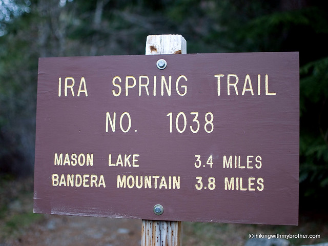
 The trail begins along the Ira Spring Trail #1039 following an abandoned roadbed for just over a tenth of a mile. When the official trail hits its first switchback up the mountain, ignore it and continue straight into the trees, following a faint boot path. The trail is unmarked and unofficial, though well maintained and easily followed once you’re on it. Avoid the paths that branch to the left and lead down the mountain. Some of these trails lead to Dirty Harry’s Peak and others snake down to I-90. Continue onward, upward, and always to the right, eventually breaking free of the trees and into rocky meadows of bear grass and, later in the season, wildflowers. As you leave the trees, the path becomes patchy and sometimes disappears; keep heading up and you’ll soon find yourself on a minor ridge leading directly to your destination.
Clamber up the pile of rocks at the top and peer carefully over the edge; there’s quite a drop down into the bowl that cups Spider Lake. Look west toward West Defiance/Web Mountain, Mt. Washington, and Dirty Harry’s Balcony just above I-90 as it disappears into the lowlands. To the north the peaks of the Alpine Lakes Wilderness spread out – on good days you can pick out Adams, Baker and Glacier. The view to the east is dominated by Mt. Defiance with Bandera Mountain close behind. And directly across the valley sits the unmistakable horn of McClellan Butte and its neighbors to the east, Mt. Kent followed by Mt. Gardner.
Short and steep, this hike is a workout. The trail builders were much more interested in expedience than preserving your knees for posterity. You’ll want to bring
 along some poles, especially for the descent, which can be tricky: many of the rocks are loose, and it is easy to send boulders careening down the slopes. We slipped and lost our footing more than once on the uneven ground. You’re unlikely to find a great deal of company on this little known route, but it affords many of the same views as other, more popular trails nearby. If you’re short on time and are up for the challenge, visit Putrid Pete’s Peak and be sure to sign the registry!
To get there, take I-90 to Exit 45, going left under the freeway to Forest Road 9030. Follow FR 9030 for about a mile until the road splits. Veer left onto FR 9031 and follow it for two more miles until the road terminates in a parking lot. – Nathan
2 Comments:
Have u ever read a Christopher Pike novel called Alosha? Do you know if Putrid is the same mountain as in the books? Check it out. Art imitating humanity...?
Rather than go down the same trail, I would strongly recommend that people take the (surprisingly easy) ridge trail to the east, which hooks up with the Mt. Defiance trail. Take that back to Mason Lake and the Ira Spring trail and give your knees a much easier trip back to your car. You also have the option of taking the spur up to Defiance itself.
Post a Comment