about us | links | permit info
Subscribe to Hiking With My Brother Email Subscribe Follow Hiking With My Brother on Facebook Follow Hiking With My Brother on Twitter Hiking With My Brother Picasa Hiking With My Brother YouTube

Wilkeson Townsite

Our Hiking Time: 1h
Total Ascent: 50ft
Highest Point: 850ft
Total Distance: 1.1 miles
Location: N 47° 6.132, W 122° 2.424
Required Permit: None
Difficulty: Easy

Nathan's Photo
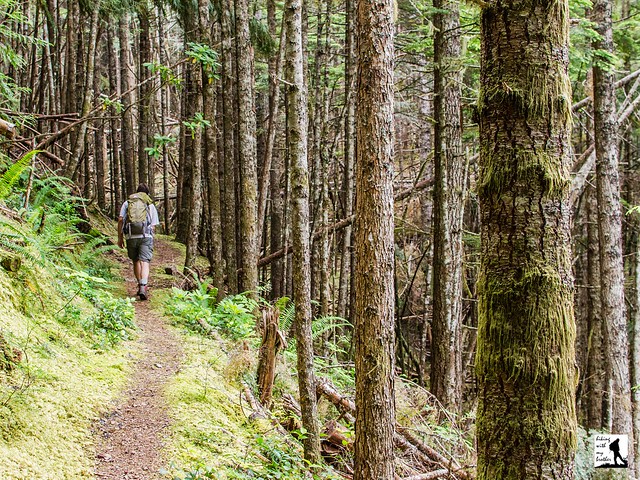
Last spring we spent a weekend in the Carbon River Valley exploring a number of mines, townsites and other historical areas. We hoped to put together a series of short hikes that would highlight the area’s rich mining history. One of the sites we visited was the town of Wilkeson, where we managed to piece together enough trail to make a decent winter hike.

Back in the late 1870s, coal was discovered along the Carbon River and a small community began to form along a creek near the riverside. Among the residents of that community was Samuel Wilkeson, who served on the Northern Pacific Board of Directors and moved to Wilkeson in 1876. By the time the Northern Pacific Railway extended track from Tacoma to the creek in 1877, both the creek and the community were named Wilkeson, in Samuel Wilkeson’s honor. With the arrival of the train, coal production went into full swing. Coal was pulled from the ground and put into coking ovens to produce coke, which was (and still is) used as an industrial fuel. The coke would then be loaded onto trains and shipped to Tacoma for use.

As the coal became more difficult to access, enterprising prospectors found extensive sandstone formations and built a quarry that began in 1886 and that still operates today. Wilkeson sandstone has been used in buildings all over Washington, perhaps most prominently on the exterior of state capitol. The town was officially incorporated in 1909.

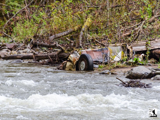
The tour begins with a visit to the coking ovens, located just off Railroad Avenue in Wilkeson. The ovens sit in a small parade ground that also contains a long section of railroad track that is used during Wilkeson’s annual railroad handcar races. The battery of ovens are now covered in vegetation, but there is easy access to the interior of a number of the ovens, as the brick-lined ceilings have begun to collapse over time. Once you’ve explored the ovens, follow the faint indications of trail that parallel Railroad Avenue and enter a lightly wooded area. After a short distance you’ll encounter a large concrete structure covered in grafitti. Our research didn’t turn up anything that told us what was once here, but we assume it has some connection to the nearby Skookum Slope Mine that was re-opened for a few years in the 1940s.

Press onward following Wilkeson Creek to a large clearing. On the far side of the clearing you find easy access to Railroad Avenue and the entrance to the Wilkeson Sandstone Quarry. While it’s private property and visitors are not allowed without prior permission, there is nothing wrong with walking up to the entrance taking a peek at the equipment and the massive stone cutting operation that has been chugging along for over 100 years. When you’re ready, double back the way you came and return to the concrete structure. From here, follow the trail up a small berm to find views of the Skookum Slope Mine at the end of a pond on the opposite site of Wilkeson Creek. Water still spills out of the grated mine entrance, and the small concrete foundation in the middle of the pond is the fan house that once pumped air into the mine shaft. Continue following the trail up the berm and notice how out of place the hill feels. That is because it’s not a hill at all, but rather a massive pile of slag and leavings from the mine that nature has since reclaimed. Soon the trail swings downhill and deposits you back at the coking ovens and the start of your tour.

Short and sweet, this hike works best during the winter months, when there will be a minimum of vegetation to get in the way and most other trails are covered in deep snow. The hike is also easily combined with other nearby townsites such as Melmont or Fairfax, which can help fill out a full day of off-season hiking. If you’re looking for an interesting walk through history, we recommend checking Wilkeson out sometime in the near future.

To get there, take I-5 South to I-405. From I-405 take SR 167 south toward Auburn. In 20 miles take the SR 410 Exit toward Sumner/Yakima. Follow SR 410 for a little over 11 miles to Mundy Loss Road. Take a right and continue for 1 mile to SR 162. Take a left and follow SR 162 as it merges into SR 165 and continue for 3 miles into Wilkeson. Turn left onto Railroad Avenue continue for .2 miles to a small parking lot on the right. -Nathan

Print Google Directions >>

Wilkeson Townsite

Evergreen Mountain Lookout Trail #1056

Our Hiking Time: 2h 30m
Total Ascent: 1300ft
Highest Point: 5600ft
Total Distance: 2.6 miles
Location: N 47° 50.1900, W 121° 15.8340
Required Permit: None
Difficulty: Moderate due to steep terrain

Nathan's Photo
Not long ago, just before the snow firmed up its hold on the mountaintops, we headed out toward Stevens Pass to squeeze one more hike along Highway 2 into 2013. We had relatives in tow and needed a hike that was not too difficult, but also offered some decent views. We went with the obvious answer -- the popular Evergreen Lookout Trail which managed to more than deliver on its promise of big views.

Evergreen Mountain is named for the large meadows that cover the flanks of the mountain. Back in 1935, the US Forest Service built a fire lookout cabin on summit as part of its fire-fighting program. During the summer months, a lookout would watch for signs of smoke and radio the ranger station if they saw a fire. During World War II, the cabin was taken over by the Aircraft Warning Service, a band of civilian volunteers organized by the US Army to keep an eye out for enemy aircraft. From 1941 to 1944 members of the Aircraft Warning Service staffed the cabin year-round, ready to scramble fighters to respond to attacking aircraft. In 1944, the US gambled and shifted all of its home defense aircraft to the offensives in Europe and the Pacific. With no one to call if the enemy was spotted, the AWS returned Evergreen Lookout to the US Forest Service.

The lookout continued to be used for fire detection through the 1980s, surviving a large burn that crept up the sides of Evergreen Mountain in 1967. Remnants of that fire can still be seen along the trail today. When flooding washed out a forest road and added seven miles to the trail, the cabin fell into disrepair. Luckily, in the 1990s it was adopted by the Seattle Explorer Search and Rescue Group, a group of Explorer Scouts that focus on search and rescue training and wilderness survival skills. The restoration was done with the support of the Mountaineers, the Quest School and 141st Army Reserve Aviation Battalion. Today, you can rent the cabin through the Forest Service and take your turn at watching over the wilderness.

The Evergreen Mountain Trail #1056 begins from the forest road, climbing quickly through meadows and past the charred and bleached reminders of the 1967 burn. As you climb, keep an eye out for the huckleberry and mountain blueberry that are plentiful along the route. The narrow trail wastes little time ascending the ridge toward mature stands of hemlock and fir. Plunge into the forest and after two-thirds of a mile enter the Wild Sky Wilderness and the trail begins to level out. Continue through the trees to large alpine meadows filled with wildflowers in season. From here you can see your destination perched in the distance. Push up the last few switchbacks and soon find yourself on Evergreen Lookout’s front porch.

The 360-degree views are vast. To the north, Glacier Peak rises above the surrounding mountains. Pick out Columbia, Kyes and Sloan Peaks to the left of Glacier. Continue turning west to first pick out Del Campo Peak and Big Four Mountain, followed by Gunn and Merchant Peak, then Baring Mountain. As you turn south find Mt. Rainier dominating the skyline, rising over nearby Beckler Peak and Alpine Baldy. As you turn east find Mount Daniel and Mount Fernow, followed by Mount Stewart and finally the rolling mountains of the Henry M. Jackson Wilderness including nearby Scrabble Mountain and Grizzly Peak. Settle in and see how many more you can pick out.

Despite the roughly 20 miles of forest roads that must be navigated to reach the trailhead, the spectacular views draw plenty of hikers every year. While is a great hike if you’re looking for big rewards on a short trail, it’s a lot of driving for just over 2.5 miles of trail. The trail is probably a little too steep and rugged for the youngest of hikers, but everyone else should be able to tackle this one without too much of a problem. If you’re looking for more trail time, we recommend combining this hike with another nearby trail, such as Beckler Peak or Scorpion Mountain.

To get there, take Highway 2 out just beyond Skykomish to milepost 50. Take a left onto FR 65, also known as the Beckler River Road. After 7 miles the pavement ends at an intersection. Veer left and continue on FR 65 for .7 miles to FR 6550. At this point, you can continue on FR 65 to Jack’s Pass to the other end of FR 6550, or cut out a few miles and jump on FR 6550 now. If you’re looking to save time, veer right onto FR 6550 and continue for 4.3 miles to FR 6554. Hook right and take FR 6554 another 8 miles to the trailhead at road’s end. -Nathan

Print Google Directions >>

Evergreen Lookout

Walt Bailey Trail to Cutthroat Lakes & Bald Mountain

Our Hiking Time: 5h 30m
Total Ascent: 2100ft
Highest Point: 4800ft
Total Distance: 9.0 miles
Location: N 47° 59.904, W 121° 39.318
Required Permit: None
Difficulty: Hard due to rough trail and navigation

Nathan's Photo
A few months ago we stumbled onto a story about the Walt Bailey Trial - a volunteer effort to rebuild a lost trail that once led out to a set of pristine alpine lakes and big views of Spada Lake. We couldn’t resist taking the trek out along the Mountain Loop Highway to see it for ourselves.
  
During the Stillagumish River’s mining heyday back around the turn of the last century, miners would begin working claims all along the river. One enterprising miner began working a claim at the mouth of a creek along the Stilliguamish, but never bothered to officially file the claim. Perhaps for that reason, folks just started referring to the creek by the name of the miner: Mallardy. Over the years Mallardy Creek and Mallardy Ridge have played host to innumerable travelers making their way up the ridge to Cutthroat Lakes and beyond.

Back in the 1930s, the Mallardy Ridge Trail ran from the Stillaguamish River up the mountainside to the Blackjack Ridge fire lookout before circling back down to the river. The pole tower lookout was built in 1935 and a cabin was added in 1942. In 1950, the decision was made to remove the lookout and the trail fell into disuse. At the same time, logging activities destroyed some sections of the trail. What was left of the trail was abandoned and it wasn’t until 1991 that former Civilian Conservation Corps veteran Walt Bailey began work on an alternative route for the Mallardy Ridge Trail. Built entirely by volunteers, including the then 73-year-old Bailey, the Mallardy Ridge Trail (often called the Walt Bailey Trail) provides access to Cutthroat Lakes and connects up to the Bald Mountain Trail.

The Mallardy Ridge (Walt Bailey) Trail #706 begins from the end of the forest road and enters a mixed forest of alder, cedar and hemlock. The narrow trail wanders through the trees to broad meadows dotted with marshy ponds. After about a mile, the trail enters the Morning Star Natural Resource Conservation Area (NCRA), which protects over 33,000 acres of land around Spada Lake. The sign at the trailhead and some trail guides reference the Mt. Pilchuck NCRA, which no longer exists. Back in 2007 the Mt. Pilchuck and Greider Ridge NCRAs were merged into today’s Morning Star NCRA.

Beyond the largest of the alpine meadows, the trail steepens and begins to switchback up through fields of talus toward Cutthroat Lakes. Arrive at the ridgeline to a small tarn with views of the lakes below. Follow the winding path as it descends down to the lakes. Along the way, numerous way paths branch off from the trail providing access to lakeshores. Stay on the widest path as it curves around the lakes and begins to climb up toward Bald Mountain. Switchback up the mountainside to the ridge, then climb up the back of the mountain to the summit. The views from the top are enormous. To the south, Mt. Rainier rises above the Spada Lake and Sultan Basin. Turn to the east to find Del Campo and Vesper Peaks, Big Four Mountain and Mount Pugh. To the north pick out Three Fingers and Whitehorse Mountain. Mt. Pilchuck can be seen to the west. Settle in and see how many mountaintops you can name.

This is a great trail with a little bit of everything - old growth forest, alpine lakes, big views, and not a lot of traffic. The trek to the top of Bald Mountain does involve a decent amount of elevation gain, but most hikers should have no problem reaching Cutthroat Lakes, which are a destination unto themselves.  Keep in mind that this is a volunteer-built trail - some sections are rough and can be a little difficult to follow.  Still, the added difficulty is more than worth the extra effort.  If you haven’t already, put the Walt Bailey Trail on your list to hike in the near future.

To get there, take I-5 North to Exit 194. Follow Highway 2 for about two miles. Stay in the left lane and merge onto Lake Stevens Highway 204. Follow for two miles to Highway 9. Take the left onto Highway 9 toward Lake Stevens. In just under two miles reach Highway 92 to Granite Falls. Take a right and follow for about nine miles to the Mountain Loop Highway. Follow the MLH for 17.8 miles to Mallardy Road (aka FR 4030). Turn right and follow the road 1.3 miles to FR 4032. Veer right onto FR 4032 and continue 5.7 miles to the end of the road and the trailhead. -Nathan

Print Google Directions >>

Walt Bailey Trail

Murhut Falls Trail #828

Our Hiking Time: 1h
Total Ascent: 300ft
Highest Point: 1100ft
Total Distance: 1.6 miles
Location: N 47° 40.422, W 123° 3.018
Required Permit: None
Difficulty: Easy

Nathan's Photo
Earlier this year we spent a weekend tromping around the Olympic Peninsula exploring a number of out-of-the-way hikes. One of our stops was Murhut Falls, a short jaunt out to a surprisingly impressive set of cascades tucked deep into a mossy ravine.

Murhut Falls is just one of quite a number of waterfalls along Murhut Creek, which flows down the flanks of  Murhut Ridge. Despite a somewhat unusual name, we have yet to track down the story behind “murhut,” though we can find references to Murhut Creek as far back as the 1920s. Much of the area was logged around the turn of the last century, a legacy that can still be seen on the sawed-off stumps that linger along the trail to this day. Times have changed, and there are now efforts underway by conservationist groups to extend the protections of The Brothers Wilderness to Murhut Falls and parts of the trail.

Some work has already gone into making Murhut Falls a little more accessible. The hike has always been a little off the beaten path, and likely because of that the trail to the falls had come degraded and somewhat treacherous. Thankfully, the trail was recently rehabilitated by the Forest Service, and the path and area around the base of the falls is in much better shape.

From the trailhead, the route begins along a former logging road, rising gently through a young forest filled with rhododendrons. The wide, smoothly graded trail soon levels out and enters stands of old growth. Eventually the logging road ends and you will find yourself on proper trail hugging the mountainside and providing a few peeks at Mt. Jupiter and Jupiter Ridge. Before long, the trail abruptly turns and climbs into a steeply-walled ravine. Lush and mossy, the ravine feels close and remote, as if you’ve suddenly been transported deep into the wilderness. Continue to the end of the trail to find the two-tiered Murhut Falls tumbling down between two large pools. Find a good spot to enjoy the view or do a little exploring near the base of the falls.

With short mileage and little elevation gain, this hike is accessible for any hiker and a great choice for bringing along the youngsters. Perhaps because this hike is under two miles, it does not see a lot of foot traffic, which means you’re likely to enjoy the roaring waterfall without too much in the way of company. If you’re looking to add some mileage to your day, we recommend combining this with a trek out to Ranger Hole, another short hike located nearby. The falls are also fairly impressive for such a short hike. If this one isn’t on your list already, we recommend exploring this short hike next time you make the trek out to the Olympics.

To get there, take I-5 south through Tacoma to Exit 132B SR 16 toward Bremerton. Continue on SR 16 for 27 miles to merge with SR 3 North. Follow SR 3 to the Hood Canal Bridge, taking a left over the bridge onto State Route 104. Follow SR 104 as it merges onto US 101 and continue 25 miles through Quilcene to Duckabush Road (FR 2150). Turn right and follow the road 6.3 miles to FR 2530 signed Murhut Falls Trail. Turn right onto and continue 1.2 miles on the gravel road to the trailhead. -Nathan

Print Google Directions >>

Murhut Falls

Hike Of The Week Calendar 2014

Jer's PhotoOur 2014 hiking calendar has a fresh spin and a reduced price! For the 3rd year in a row, we've put together a great calendar to inspire a different hiking trip every weekend in the new year. The Hike Of The Week Calendar 2014 recommends a different hike every Saturday in 2014 that we've chosen specifically with the season in mind. New this year, we've decided to showcase one hike each month with a standout photo and a colorful description of the trail.

Of course all the hike details, including directions, history, and photos can be found on hikingwithmybrother.com or in our new book Hiking Through History Washington. As an added bonus, our web publisher has dropped their printing cost so we're very pleased to offer our calendar for $14.99 down from $16.99.

A full preview of the calendar is below and we hope you pick one up this hiking season. Be sure to check Lulu.com for promotional discount codes! Use code 14CAL30 to get 30% off until January 26th!-Jer


Support independent publishing: Buy this calendar on Lulu.

North Lake via Independence Lake Trail #712

Our Hiking Time: 4h 10m
Total Ascent: 2100ft (1300ft in; 800ft out)
Highest Point: 4900ft
Total Distance: 6.0 miles
Location: N 48° 8.0280, W 121° 31.2540
Required Permit: Northwest Forest Pass
Difficulty: Hard

Nathan's Photo
A few weeks ago we headed out along the Mountain Loop Highway in search of alpine lakes and a bit of solitude. We found exactly what we were looking for near Big Four Mountain and the area around Coal Creek. Here you’ll find Independence Lake and North Lake waiting quietly for hikers to discover them.

Like most of the areas surrounding the Mountain Loop Highway, the Coal Creek Basin has seen its fair share of mining and logging activity. Pulling ore and lumber down from the mountains led to fledgling communities popped up along the wagon road turned railway we now know as the Mountain Loop Highway. One such community is nearby Silverton, that started out as a mining camp back in the 1880s. Back then it was known as “Independence” and was little more than a gathering place along the Stilliguamish River for miners and their supplies. As folks settled in and began to build a more permanent presence, moves were made to incorporate the settlement into a town. In 1891 the name was changed to “Silverton” in reference to silver ore that had been found nearby. By 1905 Silverton was booming, with nearly a dozen mining companies pulling copper and silver out of nearby mines and the town boasted hotels, a newspaper and even a school. But as quickly as it grew, it was largely abandoned when the ore began to run low and mining operations moved on. By the the 1950s Silverton was a ghost town. Today, few people live year-round in the refurbished cabins that line the highway.

Still, the legacy of Silverton lingers. Independence Lake sits at the base of its namesake mountain, Independence Peak. Very likely both the lake and the mountain were named after the Independence camp that became Silverton. North Lake has a less interesting story - it was named for the North Fork of Falls Creek that drains it.

From the trailhead, the Independence Lake Trail #712 begins through young forest that quickly transitions into older growth. The trail wanders gently through hemlock and cedar, delivering you to the tree-lined shores of Independence Lake in less than three-quarters of a mile. Find plenty of logs and rocks to clamber on to get a better view of the lake. Follow the trail has rises along the shoulders of the hillsides above the lakeshore before dropping to the somewhat marshy end of the lake. Find a few campsites here as well as a backcountry toilet. Spend a few minutes enjoying the lake before continuing up to North Lake.

From Independence Lake, it can be a little confusing to find the North Lake Trail #712.1. There are a number of unmarked paths and the trail sign is all but obscured by the tree that is slowly growing around it. From the campsites follow the trail as it continues around the lake and then turns sharply uphill. From here you will switchback up the rocky slopes of Independence Peak toward your destination. The route is steep, narrow and a little rough. After about a mile, emerge from the treeline onto an open ridge overlooking a panorama of peaks and North Lake hundreds of feet below.

Whether you decide to make the descent or not, take some time to do a little exploring along the ridgeline. Clamber up the flanks of Independence Peak or follow the faint trail as it wanders to the west. Depending on your vantage point, there are quite a few mountaintops to see. To the west pick out Devils Thumb and Three Fingers in the distance. Whitehorse Mountain is just to the north of Three Fingers. To the north pick out Jumbo Mountain. Continue to follow the trail out to the end of the ridge for views to the east, including Mt. Pugh and Glacier Peak. If you're looking for a bit more of a workout, continue down to the lake shore. The path down to the lake is steep and almost primitive. Expect to use some trees as handholds as you pick your way down through boulder fields and grassy ledges cupping seasonal pools. The trail ends at the lake but the adventurous will not find the rocky shore too difficult to explore.

This is a great summer hike for those looking for an alternative to Lake Twentytwo or Heather Lake. Because the trail starts at a fairly high elevation, the trail delivers alpine lakes and decent views without much in the way of mileage. However, the high elevation means that the snows come early and linger until June or July. Still, once the trails are clear this hike has options for every hiker: the route to Independence Lake works well for the littlest hikers or anyone looking for a quick and easy walk in the woods, and those looking for more of a challenge can push on to North Lake and beyond.

To get there, take I-5 North to Exit 194. Follow Highway 2 for about two miles. Stay in the left lane and merge onto Lake Stevens Highway 204. Follow for two miles to Highway 9. Take the left onto Highway 9 toward Lake Stevens. In just under two miles, you’ll reach Highway 92 to Granite Falls. Take a right and follow for about nine miles to the Mountain Loop Highway. Take the MLH for 25.5 miles, just past the Big Four Picnic Area to Forest Road 4060 (signed Coal Lake Road). Take a left onto FR 4060 and follow the road, veering right when the road splits at .8 miles. Find the trailhead at the end of the road, 4.7 miles from the highway. -Nathan

Print Google Directions >>

North Lake

Steam Donkey Trail - Dosewallips State Park

Our Hiking Time: 1h 15m
Total Ascent: 450ft
Highest Point: 500ft
Total Distance: 3.0 miles
Location: N 47° 41.3820, W 122° 54.1860
Required Permit: Discover Pass
Difficulty: Easy

Nathan's Photo
A few months ago we spent a weekend exploring a number of hikes along the eastern shores of the Olympic Peninsula. We managed to fit in a wide variety of destinations that included everything from mountaintops to leisurely forest walks. Among those forest walks was the Steam Donkey Loop Trail, quietly tucked into the woods surrounding Dosewallips State Park.

Before Europeans made it to the Puget Sound, Native American tribes lived and traded along Hood Canal and the rivers that flow into it, including the Dosewallips River. The name is derived from the Twana word “dos-wail-opsh,” in reference to a legendary chief who was transformed by The Great Changer into a mountain near the head of the river.

Back around the turn of the last century, the nearby town of Brinnon was quickly becoming a bustling logging community. In 1903, James Izett purchased his first timber claim in the Dosewallips River Valley, and quickly began construction of the first logging railroad south of the Dosewallips. The Izett Logging Company eventually built five miles of railroad to help haul timber down to Hood Canal where logs would be lashed together and floated down to lumber mills in booms. During this era, loggers used large steam engines - often called steam donkeys - to help pull logs and machinery up and down mountainsides. In 1910 wildfires ravaged one of the Izett logging camps, destroying two steam donkeys and a great deal of timber. Just three years later, James Izett passed away and the company was quickly sold off. The railroad was eventually removed, and today the railroad grade is still in use as part of the Dosewallips State Park trail network.

The hike begins at the Dosewallips State Park entrance booth. If you’re not camping in the park, ask the ranger where you can park to hike the trail. Usually there will be open spots right behind the booth. Once parked, follow a rough path near the booth to the Maple Valley Trailhead.  Here the actual trail begins and the path quickly enters a mixed second generation forest and soon dampens any nearby sounds from the campground. Almost immediately the Dosewallips River appears through breaks in the treeline as you glide through stands moss-heavy alders, maples and cedars. Continue following the river to a junction with the Rhody Cut-off, a shortcut that skips most of the hike and connects to the far side of the Steam Donkey Loop. Keep to the right and soon find yourself at the first of many bridges over Phantom Creek.

From Phantom Creek climb up through fields of sword fern and vine maple toward the park boundary. The trail levels out and passes by a partially cleared area that was logged a few years ago before turning sharply to the left and shortly arriving at a fire road. Cross it to connect with the Steam Donkey Loop Trail.  From here, the trail climbs slightly through the quiet forest, crossing the Phantom Creek twice before veering to the left and descending back toward the campground. On your descent pass the junction with the Izett Railroad Grade and later a junction signed "Railroad Grade Circa 1901" take a moment here to find the nearby  historical marker and look for rusted pieces of the area’s railroad history. Continue following the trail back down to the campground. The trail drops you back on the main park road. Head left back to the park entry booth.

If you’re not camping at Dosewallips State Park, this trail is better as an addition to a day of hiking in the area rather than the only hike you do. However, it works well in the winter when other hikes are less accessible and is ideal for younger hikers, as side trails and shortcuts provide ample opportunities to shorten the hike if needed. Although the park is quite popular, the trails get less traffic than expected, lending a feeling of the trail being more wild than it is. With 425 acres to explore, Dosewallips State Park is well worth a visit. Next time you’re in the area, give this “hidden” hike a try.

To get there, take I-5 south through Tacoma to Exit 132B SR 16 toward Bremerton. Continue on SR 16 for 27 miles to merge with SR 3 North. Follow SR 3 to the Hood Canal Bridge, taking a left over the bridge onto State Route 104. Follow SR 104 as it merges onto US 101 and continue 22 miles through Quilcene to Dosewallips State Park. -Nathan

Print Google Directions >>

Steam Donkey

Big Heart Lake via West Fork Foss Lakes Trail #1064

Our Hiking Time: 8h 30m
Total Ascent: 3600ft (3300ft in; 300ft out)
Highest Point: 4900ft
Total Distance: 14.0 miles
Location: N 47° 35.0760, W 19.1700
Required Permit: Northwest Forest Pass
Difficulty: Hard

Nathan's Photo
Not long ago we had the chance to spend a few days hiking through the Alpine Lakes Wilderness, enjoying the last of the summer sun. Looking to squeeze in a lot of sights on our adventure we headed toward the West Fork Foss Lakes Trail, to visit a collection of pristine alpine lakes. With the weather on our side it was easy to see why folks have been drawn to this area for decades.

Back around the turn of the last century, prospectors were exploring the Foss River Valley in search of mineral wealth. By 1906 the Foss River Consolidated Mining Company was formed out of various mining claims that had sprung up in the area. Copper Lake and Malachite Lake are part of the legacy of that era, as both were named for the presence of malachite copper ore found in the area. Today’s trail likely follows routes first cut by those early prospectors, and traces of abandoned boothpaths that once connected mining claims can still be found throughout the river valley. In 2006, flooding caused considerable damage to the West Fork Foss Lakes Trail, washing out bridges and transforming portions of the trail to rocky streambed. In 2010 the Washington Trails Association and the Ira Spring Trust worked to repair and re-route the first half-mile of trail.

From the trailhead, the West Fork Foss Lakes Trail #1064 enters a mixed forest of alder, hemlock and underbrush before crossing into the Alpine Lakes Wilderness. As you begin your climb note the dry streambed that parallels the trail, a legacy of the 2006 floods. At roughly a half-mile cross a sturdy bridge spanning a small canyon carved by those same floods. Continue climbing through deepening forest for another mile to Trout Lake. Tucked beneath the rocky slopes and exposed cliff-faces of Malachite Peak and Silver Eagle Peak, Trout Lake offers a taste of what is to come. With numerous campsites and plenty of room to fish, the lake is also a good option for backpacking with youngsters.

From Trout Lake the trail becomes steeper and rockier, switchbacking up the mountainside while following the outlet stream many folks call Copper Creek. The sheer cliffs and steep drop-offs in the area create a number of waterfalls often collectively referred to as the Waterfalls of the West Fork River Valley. Here water tumbles hundreds of feet down to the West Fork Foss River, much of which can be seen from the trail. Continue pushing up past the junction to Malachite Lake, over a bridge crossing the top of a waterfall and then across a series of stepping stones to eventually arrive at Copper Lake at just under the 4 mile mark. There is less camping at Copper Lake, though there are a few sites to be found. Copper Lake is a great destination for a day hike and the perfect place to settle down for a hard-earned break.

Continue onward along the shore of Copper Lake, through rockslides and past occasional viewpoints to the far end of the lake. Here the trail turns upward again, though the grade is more reasonable. After another mile and few hundred feet of elevation, arrive at Little Heart Lake nestled at the bottom of a rocky cirque. There is some camping here, but the real prize is another mile and a half up the trail.

The trail from Little Heart Lake to Big Heart Lake is the most challenging portion of the route. Not only does it come late in the hike, but much of the steep ascent is along exposed rocky slopes that offer big views, but little protection from the sun. The trail passes through talus fields and passes by any number of small tarns as it relentlessly pushes upward. After a little over a mile of climbing, the trail crosses over the ridge and begins quickly switchbacking down toward the lakeshore. Suddenly the trees pull away and Big Heart Lake lies sparkling before you, its shores a tangle of grey rock, bleached driftwood, vibrant evergreens and snowy ridgelines. Settle in to enjoy the view. If you’re camping, continue on the trail as it drops down to the water and crosses over a wide expanse of driftwood. From here, the trail begins to climb up a small hill. Start looking for a campsite as there are quite a few spots tucked into the hillside.

This stunning set of alpine lakes is more than worth the effort to reach them. Stacked nearly on top of one another, this trail packs a dozen big lakes into a fairly small area. The length and difficulty of this trail means that crowds tend to thin as you push closer to Big Heart Lake, making it a great backpacking destination. Still, the area is quite popular so do not expect to have the lake to yourself. However, if you’re up for a little exploring, Angeline Lake, Azurite Lake, and Chetwoot Lake can all be found beyond Big Heart Lake by following bootpaths or just doing a little bushwhacking. If you’re looking for solitude, we recommend looking there.

To get there, take Highway 2 out past Skykomish just beyond milepost 50. Take a right onto FR 68, also known as the Foss River Road. Continue on the road for 4.7 miles (the road becomes gravel after about a mile) to a junction with FR 6840. Veer left and follow FR 6840 for just under two miles to the end of the road and the West Fork trailhead. -Nathan

Print Google Directions >>

Big Heart Lake

Colchuck Lake Trail #1599.1

Our Hiking Time: 5h 15m
Total Ascent: 2300ft
Highest Point: 5600ft
Total Distance: 8.8 miles
Location: N 47° 29.6400, W 120° 50.1540
Required Permit: Northwest Forest Pass
Difficulty: Moderate

Nathan's Photo
Last week, during the final gasps of summer, we geared up for our last backpacking trip of the season. Our destination was the popular Colchuck Lake, a dazzling alpine lake at the foot of Aasgard Pass and the Enchantment Lakes Basin. With snow in the forecast we headed into the mountains hoping for a last day of blue skies before winter settled in. As luck would have it, we beat the snows by a day.

Colchuck Lake is nestled in a rocky cirque beneath a trio of craggy mountains – Enchantment, Dragontail and Colchuck Peaks – and plays host to multitudes of hikers every year. While many know that ‘colchuck’ means ‘very cold water’ or ‘ice water’ in Chinook Jargon, far fewer are aware that the glacier-filled lake acts as a irrigation reservoir for nearby farmers and residents. Back in 1926, a severe drought highlighted the need to supply water to Leavenworth and the surrounding areas during dry spells. Within a few years, the Icicle and Peshastin irrigation districts had come together with a plan to dam alpine lakes to act as reservoirs. Four lakes were ultimately chosen to supplement seasonal water flows: Colchuck, Eightmile, Klonaqua and Square lakes. By 1930, a dam was constructed at Colchuck Lake, and today’s trail likely follows a route blazed for the construction of that dam. In 2005, the dam began to fail causing the lake level to fall dramatically. Repairs the following year returned the lake to its familiar reservoir levels. Today, Colcuck Lake is part of an irrigation system that includes 60 miles of canals supplying water to over 8000 acres of farmland and orchards.

The Stewart Lake Trail #1599 begins by following Mountaineer Creek into a mixed forest of alder and pine. Within a quarter-mile the trail crosses gently into the Alpine Lakes Wilderness and the canopy slowly opens as you pass through talus fields and across log bridges. The rushing sounds of the creek remain a fairly constant companion as you steadily gain elevation along the hard-packed trail increasingly lined with Lodgepole and Ponderosa pines. At about the two-mile mark find the junction with the Colchuck Lake Trail #1599.1 (sometimes referred to as #1599A) and head left to push up toward the lake.

From the junction, the once-friendly trail becomes steep, rocky, and difficult. Rocks and roots dominate the trailbed, and tight switchbacks become common. As you navigate tricky sections of trail, keep an eye out for reasons to stop and catch your breath. You’ll cross Mountaineer Creek on a large log bridge, and soon after have a pocket-view of Colchuck Peak rising in the distance. Beyond, splashing waterfalls and broad vistas beg for a moment’s pause. As you near your destination, cross exposed granite faces and find yourself inexplicably descending dozens of feet of hard-earned elevation before beginning the final set of switchbacks up to the lakeshore.

Eventually, the trail spills out onto granite bluffs high above the north end of the lake, quickly showcasing the rocky spires that surround the blue-green lake. Across the water Aasgard Pass beckons from the low saddle between Enchantment Peak and Dragontail Peak. Further on Colchuck Glacier clings to the side of Colchuck Peak, slowly feeding the lake below. Press onward along the lake shore to find access to the shore or a suitable campsite. A designated day use area can be found next to Little Colchuck Lake a half mile down the trail.

Still thirsty for adventure? The trail continues around the lake and snakes up Aasgard Pass and into the realm of the gods: the Upper Enchantment Lakes Basin. But a word of warning; this approach is not for the inexperienced. The route is steep and can be treacherous under certain conditions, as most of the trail is comprised of boulder and scree. Be sure you know what you’re doing, and unless you have a lot of experience and training, avoid an ascent in the snow.

It’s no surprise that this eye-popping alpine lake is incredibly popular. If the stunning lake color set against a dramatic backdrop of mountaintops were not enough, the quick “backdoor” approach the Enchantment Lakes Basin provides more than enough enticement to backpackers. The rough and rocky route can be difficult, and will challenge some hikers. At the same time, this trail makes for a great backpacking destination for those looking for a training hike. If you haven’t already, find time to tackle this classic hike.

To get there, take US 2 to Leavenworth. Just before you enter town, take a right onto Icicle Creek Road (FR 76). Follow Icicle Creek Road for just over eight miles to Eightmile Road (aka FR7601). Turn left and follow the gravel road over Icicle Creek for about 4 miles to the road’s end and the parking area for Colchuck Lake and Lake Stuart. Trailhead at the far end of the lot. -Nathan


Print Google Directions >>

Colchuck Lake

Notch Pass Trail #831

Our Hiking Time: 2h 15m
Total Ascent: 1700ft
Highest Point: 2400ft
Total Distance: 4.2 miles
Location: N 47° 49.1340, W 122° 57.2880
Required Permit: None
Difficulty: Moderate

Nathan's Photo
A few months ago we spent a weekend in the eastern Olympic Mountains exploring a number of hikes around Quilcene. Among those hikes was Notch Pass, a trail-less-traveled that climbs up rugged mountainsides to a narrow pass shrouded in history.

Long before Europeans found their way to the Olympic Peninsula, bands of Native Americans were living in many different areas around the Peninsula, including the entire length of Hood Canal. These groups often needed to trade with one another and reach seasonal foraging areas deeper in the mountains. Over time, a network of trails was built to connect communities and provide easy access to resources. Today’s Notch Pass Trail likely follows a route once taken by Native Americans, leading from the Quilcene area over the Quilcene Range and down to Townsend Creek and the Big Quilcene River.

By the 1880s, farmers and loggers had settled in the area and likely used the route to access the Big Quilcene River valley. Miners found hints of mineral riches near the turn of the century, and by 1903 the Tubal Cain Copper and Manganese Mining Company was formed, drawing more people and resources down the rough trail along the Big Quilcene River. In 1930, the Civilian Conservation Corps (CCC) worked to improve the Big Quilcene River Trail and built shelters such as the Bark Shanty Shelter along the route. At the same time, the CCC also expanded the traditional route over Notch Pass. However, within just a few decades, the trail built by the CCC slowly degraded and was abandoned -- disappearing from USGS maps sometime after 1953. In 1998, a group of trail volunteers led by the Washington Trails Association worked to re-route and rebuild the trail. Since that time at least 67 WTA work parties have worked to maintain the trail. Today the shelters built by the CCC are long gone, but through the dedication of volunteers the trail remains.

The Notch Pass Trail #831 beings steeply from the roadside and climbs steadily up into a young forest of hemlock and fir. Rhododendrons and sword fern are common along the moss-lined trail as it winds steadily upward. The trail is narrow, but not overgrown or rough, helping make the trek a little more pleasant. Before you know it, you’ve put two miles behind you and the trail enters the densely wooded Notch Pass. Mossy logs cover the forest floor here, muffling the usual sounds of the forest and lending a slightly eerie feel to the area. Take some time to look around and enjoy the silence.  Continue on for a short distance to emerges from the trees onto a forest road.

For a lot of hikers the top of the Pass is a good place to have a snack and head back down to the car. But if you’re still wanting some time on the trail, the trail does continue, dropping down the backside of Quilcene Ridge -- along the way you’ll cross FR 27 and the alternative trailhead, Allen Creek, Townsend Creek and eventually find yourself exploring areas along the Big Quilcene River.

This is a decent alternative to the busy Mt. Townsend trailhead a few miles down the road, especially if you’ve already tackled Mt. Townsend and are looking for something different. What it lacks in big views, it makes up for in quiet solitude. We recommend this hike for more experienced hikers who are looking for something a little different and do not mind climbing up to Notch Pass twice on a round trip to the Bark Shanty Shelter site and the Big Quilcene River. If you’re looking for a little adventure and a healthy dose of history, give Notch Pass a try.

To get there, take the Bainbridge Island Ferry and follow State Route 305 through Poulsbo to State Route 3. Follow SR 3 to the Hood Canal Bridge, taking a left over the bridge onto State Route 104. Follow SR 104 as it merges onto US 101 and continue 11.3 miles through Quilcene to Penny Creek Road. Take a right and continue 1.4 miles to the Big Quilcene River Road (FR 27). Veer left onto the Big Quilcene River Road (FR 27) and continue for just under a mile to unmarked FR 27-010 on the right. This narrow dirt road is easy to miss; look for a road that connects to the main road in a “Y,” splitting around a small wooden structure. (If you reach the National Forest boundary you have gone too far.) Head right onto FR 27-010 for about a mile to the signed trailhead. -Nathan

Print Google Directions >>

Notch Pass

Grand Park Backdoor via Lake Eleanor Trail

Our Hiking Time: 3h 30m
Total Ascent: 1100ft
Highest Point: 5600ft
Total Distance: 8.5 miles
Location: N 46° 57.7080, W 121° 40.9203
Required Permit: None
Difficulty: Moderate

Nathan's Photo
Mt. Rainier National Park boasts dozens of hikes leading out to dramatic landscapes dominated by the looming volcano. Few are more iconic than Grand Park; a sea of meadows and wildflowers lapping at the base of Mt. Rainier. The classic approach from Sunrise is long and tough, putting Grand Park out of reach for most casual day hikers. Luckily, there is an unofficial “backdoor” approach via Lake Eleanor that allows many more hikers to enjoy this stunning destination.

Around 500,000 years ago, Mt. Rainier began a cycle of volcanic activity that culminated in the mountain we see today. For thousands of years, volcanic rock boiled to the surface and built up the mountain, each time also producing a layer of pyroclastic flow. With the next eruption, softer pyroclastic flow would be covered by harder layers of thick lava that are more resistant to erosion. The plateau that Grand Park covers is an example of a hard layer of lava that remained as softer rock eroded around it. The area is among the largest open meadows in the national park, and was given the name Grand Park by park officials.

The “backdoor” approach likely began as a boot trail used by fishermen to access Lake Eleanor. This 20 acre alpine lake and the creek that drains it were named around the turn of the 20th century by Burgon D. Mesler in honor of his wife Eleanor. The Mesler family were early settlers in the area, running an inn and other amenities that catered to travelers heading over the Cascades or visiting the park.

The hike begins just off FR 73, following a bootpath along the edge of Eleanor Creek. The trail enters a mixed forest and begins a moderate climb toward Lake Eleanor. Within a half-mile, you will cross into Mt. Rainier National Park and in another mile or so you will arrive at the lakeside. There are a few campsites around Lake Eleanor that provide nice views of the lake and a pleasant place for a snack, though most hikers will be eager to push on to the meadowlands ahead.

From the lake the trail steepens and climbs through larger stands of hemlock and fir. The moderate climb is broken up by short wanderings through progressively larger meadows. Push onward and upward to the wide expanses of Grand Park. Often filled with wildflowers during the spring and summer months, the miles-long grassland can seem to be awash in color from the moment you arrive. Resist the temptation to linger at the edges, and continue on to the meadow’s highpoint for outstanding views of the mountain. Find a comfortable spot to settle in and soak up the panorama. If you're hungry for more you can continue all the way through Grand Park's meadows to connect with the North Loop Trail and the rest of the Wonderland Trail.

We highly recommend this approach to Grand Park. Not only is the trail fairly approachable for almost all hikers, but the Lake Eleanor route is usually accessible long after the road to Sunrise is closed for the season. Although the trail may have been difficult to navigate in the past, its popularity has brought thousands of boots to soften it up, and today the path is almost as well-maintained as an official trail. One word of caution: the area around Grand Park is the perfect breeding ground for mosquitoes and other bugs. Be sure to come prepared during the spring and summer months. If you haven’t made it out to Grand Park yet, add this one to the top of your list of future hikes.

To get there, take I-5 south to Highway 18 Exit 142A. Follow Highway 18 into Auburn and take the SR 164 Exit. Head left on SR 164 through Enumclaw to SR 410. Head left onto SR 410 for 25 miles to Huckleberry Creek Road (FR 73). Turn right onto FR 73 and follow for 6 miles to cross the Huckleberry Creek bridge. Continue on FR 73 as it climbs for another 4 miles to the bridge crossing Eleanor Creek, which is signed. There is no official trailhead, but there is room for a number of cars to park. -Nathan

Print Google Directions >>

Grand Park
Copyright 2008-2016 - hikingwithmybrother.com
hikingwithmybrother@gmail.com