about us | links | permit info
Subscribe to Hiking With My Brother Email Subscribe Follow Hiking With My Brother on Facebook Follow Hiking With My Brother on Twitter Hiking With My Brother Picasa Hiking With My Brother YouTube
Showing posts with label backpacking. Show all posts

Deep Lake via Cathedral Pass Trail #1345

Our Hiking Time: Overnight
Total Ascent: 3400ft (2200ft in; 1200ft out)
Highest Point: 5600ft
Total Distance: 15 miles
Location: N 47° 32.5683, W 121° 8.3816
Required Permit: Northwest Forest Pass
Difficulty: Moderate

Nathan's PhotoRecently we decided to get one last overnight in before the snows seal off the mountains for a few months. We wanted to capture some fall color so we headed out to the Salmon la Sac area to tackle Cathedral Rock and explore some nearby alpine lakes. With good weather on our side, we enjoyed spectacular autumn landscapes and the quiet of the wilderness.

Back in the late 1800s, prospectors and sheepherders were far more common in this area than hikers. One of those prospectors was a gold miner named James “Jimmy” Grieve, who was likely the first to scale Cathedral Rock. As a result it was known as Grieve’s Peak and Jimmy’s Jumpoff for years. The name did not sound regal enough for the Forestry Service, so someone in the 1940s or 50s decided Cathedral Rock was a better fit. Grieve had several claims in the area and built a cabin near Peggy’s Pond that was a popular site for hikers to visit for decades, though it is little more than a pile of crumbling logs today. The story behind some of the places in the area is a bit murkier. Supposedly it was Spanish-speaking shepherds that gave the Spinola Meadows their name. Deep Lake, unsurprisingly, was named for its depth, perhaps by the same folks that decided Grieve’s Peak somehow resembled a cathedral.

The Cathedral Pass Trail #1345 begins from the Cathedral Pass Trailhead (officially part of the Tucquala Meadows Trailhead), near the end of FR 4330. From the parking area, craggy Cathedral Rock juts dramatically into the skyline, giving you some perspective on the hike ahead. The rocky trail begins without fanfare, crossing a few creeks before beginning a series of long switchbacks, slowly ratcheting up the mountainside. After .4 miles the trail brings you into the Alpine Lakes Wilderness without fanfare, drawing you past brushy undergrowth and deeper into dark stands of hemlock and fir. Soon the trail begins to level out and at the 2.2 mile mark reaches the junction to the Lake Waptus Trail #1322. Push ahead for another .5 mile to your first destination, Squaw Lake. There are a number of campsites around this little tarn, as well as a backcountry toilet, making it a decent option for a quick overnight with the kids or basecamp for exploring the area trails.

From Squaw Lake, the trail begins a long, rocky traverse up to Cathedral Pass offering occasional views of the Wenatchee Mountains just to the east, while snaking past the occasional pond. Continue to push upwards through the thinning sub-alpine forest for another two miles to the connection with the Pacific Crest Trail #2000 at the 4.2 mile mark. Cathedral Pass is less than .25 mile up ahead, so climb the last few feet to the 5400’ pass, though do not expect a lot of fanfare - there is not much in the way of big panoramic views. But be sure to take a moment to scan the cliffs for mountain goats before beginning the long descent down into the Spinola Valley.

Compared to the Cathedral Pass Trail the Pacific Crest Trail is a breeze. Wide and almost smooth, the trail gently guides you down the mountainside. At the first big switchback you’ll reach the junction with the Peggy’s Pond Trail #1375 - it’s a decent .6 mile side trip out to a lovely tarn, though the trail is rough and somewhat challenging to navigate. Most hikers will opt to continue down another three miles to Spinola Meadows and the shores of Deep Lake, 7.5 miles from the trailhead. As you descend, enjoy a bird’s-eye view of Deep Lake and the valley below as well as Circle Lake Falls cascading down the opposite side of the valley into the lake below. Depending on the season, you may be in for quite a show before the views disappear into the trees as you re-enter the forest. Eventually you’ll reach the bottom and the old growth will give way to meadow. Here the barren cliffs of Cathedral Rock rise dramatically above Deep Lake, demanding your attention as you take in the panorama. Take some time to explore the shore before settling in - there are plenty of campsites around the lake for those planning to spend the night and you can afford to find the best vantage point to take in this gorgeous alpine landscape.

This hike is a classic, offering some of the best the Alpine Lakes Wilderness has to offer: a pristine alpine lake, views of the surrounding rugged landscape, and the quiet solace of the wilderness. While some hikers can tackle this one as a day hike, the distance really lends itself better to an overnight or a multi-day exploration of the area, as there are a number of destinations right nearby including a popular scramble route up Mt. Daniel by way of Peggy’s Pond.

To get there, take I-90 out over Snoqulamie Pass to Exit 80. Head left over the freeway following Bullfrog Road to SR 903. Follow 903 16.6 miles through Roslyn and along Cle Elum Lake to FR 4330 just beyond the Salmon La Sac guard station. Veer right, avoiding the campground and continuing onto the dirt and gravel FR 4330 for 12.3 miles to the Cathedral Pass Trailhead. Privy available. -Nathan

Print Google Directions >>
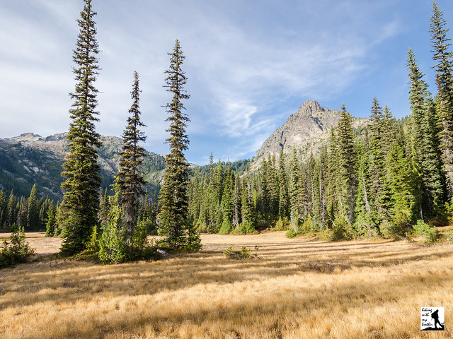
Deep Lake

Carbon Glacier via Carbon River Road

Our Hiking Time: 10h
Total Ascent: 2300ft
Highest Point: 4100ft
Total Distance: 18.6 miles
Location: N 46° 56.4600,  W 121° 47.0459
Required Permit: National Park Pass
Difficulty: Moderate

Nathan's PhotoWe’ve done a lot of hiking in the Carbon River Valley this year, exploring quite a few trails in the area. After seeing so much of the river, we thought it only appropriate to head out to the Carbon Glacier to see where it all begins. While we expected to find a wall of ice, we underestimated just how impressive the river’s source would be.

Like the Carbon River, the Carbon Glacier was named in 1876 for the abundance of coal found along the upper reaches of the river, which fueled boom towns such as Fairfax, Melmont and Carbonado. Outside of Alaska, the Carbon Glacier has the distinction of being not only the longest, thickest and most voluminous glacier in the United States; it is also the lowest elevation. Perhaps because of its enormous size the glacier was something of an attraction, and park administrators began developing the Carbon River area almost immediately after the park was created in 1899. By 1923, the Carbon River Road was completed, ending just a mile shy of the glacier itself. For a few years, hikers could drive the entire length before floods and washouts would close more and more sections of the road. Today, the road is closed at the Carbon River Entrance and park officials are pushing to make the closure permanent.

The hike begins from the Carbon River Entrance, following the Carbon River Road through a temperate rain forest of fir and cedar. The road provides access to a number of hikes, and many people opt to bike the road to cut down on travel time, though there is something to be said for the more leisurely walk through the woods. Flat and wide, the miles pass quickly and easily, passing the Green Lake Trailhead after about three miles and the Chenuis Falls Trailhead another half-mile or so beyond. The river is your constant companion as you push past these popular day hikes toward Ipsut Campground. The campground is a good place to stop for a breather or to set up camp if you’re planning on a longer trip.

Continue past Ipsut Campground following the Wonderland Trail deeper into the lush forest for another 1.7 miles to the junction with the Northern Loop Trail. While older guides will suggest that you continue on the Wonderland Trail to Carbon River Camp, that section of trail is currently closed. Instead, veer left crossing the logs the span various sections of the Carbon River, eventually crossing the rocky riverbed. Look upstream to catch your first glimpse of the glacier, through it will likely look more like a distant mountain than an ice field. Once across, climb up the riverbank to find a junction where the Northern Loop Trail splits. Head right, continuing to follow the river as the trail wanders through mossy old growth and over endless streams and creeklets. After another mile and a half reach the Carbon River Suspension Bridge, built in 1984 as an answer to the constant need to replace the bridge that spanned this area for decades. If you have a little extra time, we recommend taking a few moments to cross the bridge and head out to Cataract Falls, just a few tenths of a mile from the river. The bridge also provides easy access to Carbon River Camp, another option for those planning an overnight.

From the bridge, the hike becomes a little more challenging, beginning to climb up the steep valley the glacier carved years ago. As you progress the trees fall away, providing big views of the enormous glacier and the river surging from the base of a icy wall hundreds of feet tall. There are plenty of places to stop along the way, though we recommend pushing onward and upward to Dick Creek Camp for views of the glacier and the valley below.

This is a classic hike, though since the road closure it is a little on the long side for a day hike. At the same time most of the distance is along the Carbon River Road, which can be biked or hiked without much effort. With several campsites near the glacier, there are a lot of options for adding a hike to the Carbon Glacier to an overnight or multi-day backpack. And while the first few miles of the Carbon River Road tend to have a lot of traffic, the crowds quickly thin beyond the Chenuis Falls Trailhead.

To get there, take I-5 South to I-405. From I-405 take SR 167 south toward Auburn. In 20 miles take the SR 410 Exit toward Sumner/Yakima. Follow SR 410 for 12 miles to SR 165. Take a right and continue on SR 165 for about 10 miles through Wilkeson and Carbonado to the Carbon River Road/Mowich Lake Road junction. Veer left onto the Carbon River Road and follow for 7.7 miles to the Carbon River Entrance of Mt. Rainer and parking. -Nathan

Print Google Directions >>

Carbon Glacier

Big Heart Lake via West Fork Foss Lakes Trail #1064

Our Hiking Time: 8h 30m
Total Ascent: 3600ft (3300ft in; 300ft out)
Highest Point: 4900ft
Total Distance: 14.0 miles
Location: N 47° 35.0760, W 19.1700
Required Permit: Northwest Forest Pass
Difficulty: Hard

Nathan's Photo
Not long ago we had the chance to spend a few days hiking through the Alpine Lakes Wilderness, enjoying the last of the summer sun. Looking to squeeze in a lot of sights on our adventure we headed toward the West Fork Foss Lakes Trail, to visit a collection of pristine alpine lakes. With the weather on our side it was easy to see why folks have been drawn to this area for decades.

Back around the turn of the last century, prospectors were exploring the Foss River Valley in search of mineral wealth. By 1906 the Foss River Consolidated Mining Company was formed out of various mining claims that had sprung up in the area. Copper Lake and Malachite Lake are part of the legacy of that era, as both were named for the presence of malachite copper ore found in the area. Today’s trail likely follows routes first cut by those early prospectors, and traces of abandoned boothpaths that once connected mining claims can still be found throughout the river valley. In 2006, flooding caused considerable damage to the West Fork Foss Lakes Trail, washing out bridges and transforming portions of the trail to rocky streambed. In 2010 the Washington Trails Association and the Ira Spring Trust worked to repair and re-route the first half-mile of trail.

From the trailhead, the West Fork Foss Lakes Trail #1064 enters a mixed forest of alder, hemlock and underbrush before crossing into the Alpine Lakes Wilderness. As you begin your climb note the dry streambed that parallels the trail, a legacy of the 2006 floods. At roughly a half-mile cross a sturdy bridge spanning a small canyon carved by those same floods. Continue climbing through deepening forest for another mile to Trout Lake. Tucked beneath the rocky slopes and exposed cliff-faces of Malachite Peak and Silver Eagle Peak, Trout Lake offers a taste of what is to come. With numerous campsites and plenty of room to fish, the lake is also a good option for backpacking with youngsters.

From Trout Lake the trail becomes steeper and rockier, switchbacking up the mountainside while following the outlet stream many folks call Copper Creek. The sheer cliffs and steep drop-offs in the area create a number of waterfalls often collectively referred to as the Waterfalls of the West Fork River Valley. Here water tumbles hundreds of feet down to the West Fork Foss River, much of which can be seen from the trail. Continue pushing up past the junction to Malachite Lake, over a bridge crossing the top of a waterfall and then across a series of stepping stones to eventually arrive at Copper Lake at just under the 4 mile mark. There is less camping at Copper Lake, though there are a few sites to be found. Copper Lake is a great destination for a day hike and the perfect place to settle down for a hard-earned break.

Continue onward along the shore of Copper Lake, through rockslides and past occasional viewpoints to the far end of the lake. Here the trail turns upward again, though the grade is more reasonable. After another mile and few hundred feet of elevation, arrive at Little Heart Lake nestled at the bottom of a rocky cirque. There is some camping here, but the real prize is another mile and a half up the trail.

The trail from Little Heart Lake to Big Heart Lake is the most challenging portion of the route. Not only does it come late in the hike, but much of the steep ascent is along exposed rocky slopes that offer big views, but little protection from the sun. The trail passes through talus fields and passes by any number of small tarns as it relentlessly pushes upward. After a little over a mile of climbing, the trail crosses over the ridge and begins quickly switchbacking down toward the lakeshore. Suddenly the trees pull away and Big Heart Lake lies sparkling before you, its shores a tangle of grey rock, bleached driftwood, vibrant evergreens and snowy ridgelines. Settle in to enjoy the view. If you’re camping, continue on the trail as it drops down to the water and crosses over a wide expanse of driftwood. From here, the trail begins to climb up a small hill. Start looking for a campsite as there are quite a few spots tucked into the hillside.

This stunning set of alpine lakes is more than worth the effort to reach them. Stacked nearly on top of one another, this trail packs a dozen big lakes into a fairly small area. The length and difficulty of this trail means that crowds tend to thin as you push closer to Big Heart Lake, making it a great backpacking destination. Still, the area is quite popular so do not expect to have the lake to yourself. However, if you’re up for a little exploring, Angeline Lake, Azurite Lake, and Chetwoot Lake can all be found beyond Big Heart Lake by following bootpaths or just doing a little bushwhacking. If you’re looking for solitude, we recommend looking there.

To get there, take Highway 2 out past Skykomish just beyond milepost 50. Take a right onto FR 68, also known as the Foss River Road. Continue on the road for 4.7 miles (the road becomes gravel after about a mile) to a junction with FR 6840. Veer left and follow FR 6840 for just under two miles to the end of the road and the West Fork trailhead. -Nathan

Print Google Directions >>
Big Heart Lake

Snow Lakes Trail #1553 to Enchantment Lakes

Our Hiking Time: 9h
Total Ascent: 4200ft
Highest Point: 5500ft
Total Distance: 13.6 miles
Location: N 47° 29.1540, W 120° 44.9100
Required Permit: Northwest Forest Pass, Enchantments Permit for overnight stays
Difficulty: Hard

Nathan's PhotoOne of our backpacking excursions last fall took us into the Alpine Lakes Wilderness and up to The Enchantments. While we have backpacked through the region before, this was the first time we have been able to experience the fall colors and the changing of the seasons. Our approach took us up to Snow Lakes, a popular stopover point for those heading up to the Enchantments Basin.

Back in the 1930s the construction of the Grand Coulee Dam had an immediate impact on salmon runs. The Bureau of Land Reclamation worked to solve the issue through fish hatcheries, one of which was built on Icicle Creek to release into the Wenatchee River below the dam. Unfortunately, the Bureau quickly realized that fluctuations in the water levels of Icicle Creek would cause problems for a sustainable hatchery. The problem was a lack of cold water; the solution was to tap the nearby Snow Lakes seven miles upstream.

In 1938 the Forest Service cut a trail up to Nada Lake and the Snow Lakes and a base camp was established on Nada Lake. From 1939-1942 crews worked to drive a 9-foot wide, 2,250-foot long tunnel through solid granite under Lower Snow Lake to the bottom of Upper Snow Lake. At the same time, a small dam was constructed to regulate the water levels between the upper and lower lake. Today, water drains from the bottom of the 150-foot deep Upper Snow Lake to a bulkhead where it is funneled into a pipe and shot out toward Nada Lake. A series of valves controls the amount of water discharged. On average the system is in operation 77 days a year, usually between July and October, and releases an average of 3,700 acre-feet of water.

The hike to Snow Lakes begins from the parking lot by following a maintenance road over Icicle Creek and past concrete canals. From the road the trail begins a slow switchback up into the sloping canyon. As you climb, evidence of the fires that ravaged the area in 1994 can still be seen. The skeletons of charred trees line the trail, though after nearly 20 years the underbrush has obscured much of the damage. However, the underbrush has yet to grow up enough to provide much in the way of shade, so this first section of the hike has a lot of sun exposure, making it hot and dusty during the summer.

As you leave the burn area and the faint smell of ash behind, the trail enters a pine forest and bends closer to Snow Creek, providing access to occasional creekside rest stops. Around the two mile mark the trail meanders past large cliff faces that are frequented by rock climbers and soon begins to veer up the rocky canyon slopes. Continue another two miles through talus fields, scattered sections of forest and brush-lined sections of trail to the sturdy footbridge crossing Snow Creek. Soon find yourself sharing the trail with Nada Creek as you push up to the marshy end of Nada Lake. While most hikers press onward to Snow Lakes on their quest to reach the Enchantments Basin, some choose to overnight in the quiet solitude of Nada Lake. Several campsites line the lower section of the lake. If nothing else, the shores of Nada Lake are an excellent resting point to recharge for the final push to Snow Lakes a mile and a half up the trail.

Continuing onward, the trail quickly and steeply rises up the slopes above Nada Lake. If water is being released from Snow Lake, you will see the spray gushing from the cliffs above Nada Lake. As you get closer, at a switchback in the trail, a bootpath leads out to the tunnel and the control valves for the drainage system. Push upward through rocky terrain to the relief of the forests that surround Snow Lakes. The trail leads across the small dam that controls the water level between the lakes. Depending on the time of year, Upper Snow Lake may be quite low, exposing sandy shores covered in the bleached wood of fallen trees. The craggy heights of The Temple rise dramatically above Upper Snow Lake creating a scene that epitomizes the Alpine Lakes Wilderness. Many campsites can be found around both lakes.

Snow Lakes is a decent backpacking destination unto itself, though most folks undertake the dusty trek with the intent of pushing upward into the Enchantments Basin. Because permits to overnight in the core Enchantments Zone can be hard to come by, the Snow Lakes make a perfect base camp for day hiking the area by using the more easily obtained overnight Snow Lakes Permit. Somewhat challenging, this trip is best taken in the company of those with at least some wilderness and backpacking experience. It can be done as a long day hike, though we recommend against it. The difficulty of the trail on a hot summer day combined with the chance that Upper Snow Lake could be low and somewhat less than majestic probably makes this a little too much effort for one day. Save this one for a short overnight or as part of your exploration of the Enchantments Basin.

To get there, take US 2 to Leavenworth. Just before you enter town, take a right onto Icicle Creek Road (FR 76). Follow Icicle Creek Road for just over four miles to a large parking lot on your left. Park and find the trailhead at the far end of the lot. -Nathan

Print Google Directions >>

Snow Lakes

Goldmyer Hot Springs via Middle Fork Trail #1003

Our Hiking Time: 10h
Total Ascent: 2000ft (1000ft out)
Highest Point: 2100ft
Total Distance: 22 miles
Location: N 47° 28.9320, W 121° 23.0520
Required Permit: Northwest Forest Pass
Difficulty: Moderate

Nathan's PhotoWe’ve spent a lot of time in the Middle Fork Snoqualmie Valley the past few years. We’ve climbed mountains, followed creeks to spectacular waterfalls, and explored hidden lakes. But, despite hearing a lot about it, we had not yet made it out to one of the valley’s signature destinations: Goldmyer Hot Springs. As autumn continues to bring cooler temperatures, we set out on a short overnight to see the springs before winter set in.

goldmyer hot springs hikingwithmybrotherGoldmyer Hot Springs is named for William Goldmyer, who purchased the land around the hot springs and built a lodge for local lumberjacks and miners around 1900. The lodge eventually became something of a resort, and the hot springs were expanded. Back around the turn of the 20th century, mineral springs were big business as people sought them out for their restorative properties. The resort operated for many years, supported by a railroad that made access much easier than it is today, as well as emerging hydroelectric technology that powered the encampment. Eventually the resort closed, the land changed hands, and the hot springs went into decline until the ‘80s when a nonprofit group bought the land and began a program of resident caretakers that continues to this day.

Currently, because of a road closure, access to Goldmyer is a 10 mile riverside stroll following the Middle Fork Trail #1003. This trail is extremely well maintained. The effort that trail volunteers put into it is readily apparent in the extensive network of bridges and boardwalks. Although goldmyer hot springs hikingwithmybrotherthere are a few ups and downs, for the most part the trail generally follows the remnants of old logging roads and is fairly gentle. Wander under alders, hemlocks, and big leaf maples, and take advantage of breaks in the canopy to see Mt. Garfield, the granite cliffs of Stegosaurus Butte, and Mt. Thompson. Cross roaring creeks, tumbling cascades, and the occasional wash-out before reaching Goldmyer and a well-earned soak.

There are two approaches to the hot springs. Both follow the Middle Fork Trail for 6 miles to the Dingford Creek Bridge. At this point, you can continue on the Middle Fork Trail for another 4 miles to Burntboot Creek and a log crossing to the Goldmyer property. Alternatively, you can cross the bridge and follow the Dingford Creek Road 4 miles to Goldmyer. The forest road is not as enjoyable as the trail, but a couple unbridged creeks can be difficult to cross when waters run high during the spring thaw or heavy rains.

The hot springs themselves are fairly small. Probably no more than 10 people can fit in the various pools at any one time. Perhaps for this reason, Goldmyer limits camping to 20 people a day and groups to no more than 12. Although a reservation is not strictly necessary, it will guarantee you a campsite during the busy summer season. Check out goldmyer.org for more details.

This is a great hike for beginning backpackers. The ease of the trail goldmyer hot springs hikingwithmybrotherand the comfortable destination (the tent sites are well groomed, the nearby river makes for easy access to water, and an enclosed outhouse borders on luxury) make it easy to convince the skeptics that backpacking is a lot of fun. Moreover, the Middle Fork Trail is really a pleasant journey that takes you though some of the best portions of the valley. The Middle Fork Trail route also allows for some interesting side trips for those looking for a little extra. At the 5-mile mark, you reach Cripple Creek and a mile-long scramble up to Tin Cup Joe Falls. At just over 8 miles, the trail intersects with the Rock Creek Trail #1013.1, which leads out to Snow Lake and Snoqualmie Pass.

To get there, take Exit 34 off I-90 and take a left on 468th Ave. Follow the road past the truck stop for about a half-mile until you reach SE Middle Fork Road, also known as Forest Road 56. Continue to follow the twists in the road until the pavement runs out. Continue on FR 56 for 11 miles, to the Middle Fork Trailhead parking lot. The trailhead and Gateway Bridge are at the north end of the lot. - Nathan

Print Google Directions >>

Goldmyer Hot Springs

Talapus and Olallie Lakes

Our Hiking Time: 2h 30m round trip to Olallie
Total Ascent: 650ft to Talapus, 1150ft to Olallie
Highest Point: 3800ft
Total Distance: 4.5miles round trip to Talapus, 6.5miles round trip to Olallie
Location: N 47° 24.8287, W 121° 30.9840
Required Permit: Northwest Forest Pass
Difficulty: Easy

Nathan's PhotoAfter weeks of ascending peaks such as Bandera and Teneriffe, we were looking forward to a change in our routine. We had not stood on the shore of an alpine lake since Melakwa Lake and realized a lake hike was long overdue. After some research we decided to explore some of the more popular alpine lakes in the region: Talapus and Olallie lakes.

talapus lake olallie lake hikingwithmybrotherNestled within the Alpine Lakes Wilderness, Talapus and Olallie Lakes are among the most easily accessible lakes in the region. Established in 1976, the nearly 400,000-acre Alpine Lakes Wilderness hosts more than 700 lakes. Like so many place names in the area, these lakes bear the legacy of the early interaction of pioneers and Native Americans. Talapus translates to “coyote” in the pidgin language Chinook Jargon, while Olallie roughly means “berry.” Largely born through the necessity of trade, Chinook Jargon is an amalgamation of French, English and Salishan languages native to the Pacific Northwest.

talapus lake olallie lake hikingwithmybrotherTalapus Lake Trail #1039 begins with a gentle wander on wide track through the woods, crossing Talapus Creek and traversing marshy areas through a long series of bridges and raised walkways. Long switch backs and mild grades follow Talapus Creek a little over a mile into the Alpine Lakes Wilderness to reach Talapus Lake, tucked in a bowl between Bandera and Pratt Mountain. Find various small paths winding around the lake that travel past nooks, perfect for a snack or extended stay, overlooking the water.

Continue past Talapus on #1039 toward the smaller Olallie Lake three-quarters of a mile distant, passing a small trail connecting #1039 to the Pratt Lake Trail #1007. Enjoy the meander through the mature cedars and firs until you reach the wooded lake, resting beneath West Granite Mountain and Pratt Lake Saddle.

Both of these lakes are extremely popular in the summer months, so etalapus lake olallie lake hikingwithmybrotherxpect company as you take the short trek up. This hike is a great introduction to the Alpine Lakes Wilderness and is extremely family-friendly. For the more adventurous, the connection to the Pratt Lake Trail provides access to a myriad of destinations beyond the lakes’ crowded shores. Winter or summer, this hike provides a tempting taste of the wilderness – the clarity of the water is interrupted only by the reflections of the surrounding landscapes, making it easy to forget the relatively close trappings of civilization.

To get there, take I-90 to Exit 45, going under the freeway to Forest Road 9030. Follow FR 9030 for about a mile until the road splits. Continue on FR 9030 to the right and follow it for a little over two miles until you reach the trailhead parking lot. -Nathan

Print Google Directions >>

Talapus & Olallie Lakes
Copyright 2008-2016 - hikingwithmybrother.com
hikingwithmybrother@gmail.com