Our Hiking Time: 4h 10m
Total Ascent: 2100ft (1300ft in; 800ft out)
Highest Point: 4900ft
Total Distance: 6.0 miles
Location:
N 48° 8.0280, W 121° 31.2540
Required Permit:
Northwest Forest Pass
Difficulty: Hard

A few weeks ago we headed out along the Mountain Loop Highway in search of alpine lakes and a bit of solitude. We found exactly what we were looking for near Big Four Mountain and the area around Coal Creek. Here you’ll find Independence Lake and North Lake waiting quietly for hikers to discover them.
Like most of the areas surrounding the Mountain Loop Highway, the Coal Creek Basin has seen its fair share of mining and logging activity. Pulling ore and lumber down from the mountains led to fledgling communities popped up along the wagon road turned railway we now know as the Mountain Loop Highway. One such community is nearby Silverton, that started out as a mining camp back in the 1880s. Back then it was known as “Independence” and was little more than a gathering place along the Stilliguamish River for miners and their supplies. As folks settled in and began to

build a more permanent presence, moves were made to incorporate the settlement into a town. In 1891 the name was changed to “Silverton” in reference to silver ore that had been found nearby. By 1905 Silverton was booming, with nearly a dozen mining companies pulling copper and silver out of nearby mines and the town boasted hotels, a newspaper and even a school. But as quickly as it grew, it was largely abandoned when the ore began to run low and mining operations moved on. By the the 1950s Silverton was a ghost town. Today, few people live year-round in the refurbished cabins that line the highway.
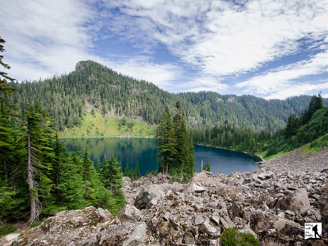
Still, the legacy of Silverton lingers. Independence Lake sits at the base of its namesake mountain, Independence Peak. Very likely both the lake and the mountain were named after the Independence camp that became Silverton. North Lake has a less interesting story - it was named for the North Fork of Falls Creek that drains it.
From the trailhead, the Independence Lake Trail #712 begins through young forest that quickly transitions into older growth. The trail wanders gently through hemlock and cedar, delivering you to the tree-lined shores of Independence Lake in less than three-quarters of a mile. Find plenty of logs and rocks to clamber on to get a better view of the lake. Follow the trail has rises along the shoulders of the hillsides above the lakeshore before dropping to the somewhat marshy end of the lake. Find a few campsites here as well as a backcountry toilet. Spend a few minutes enjoying the lake before continuing up to North Lake.

From Independence Lake, it can be a little confusing to find the North Lake Trail #712.1. There are a number of unmarked paths and the trail sign is all but obscured by the tree that is slowly growing around it. From the campsites follow the trail as it continues around the lake and then turns sharply uphill. From here you will switchback up the rocky slopes of Independence Peak toward your destination. The route is steep, narrow and a little rough. After about a mile, emerge from the treeline onto an open ridge overlooking a panorama of peaks and North Lake hundreds of feet below.
Whether you decide to make the descent or not, take some time to do a little exploring along the ridgeline. Clamber up the flanks of Independence Peak or follow the faint trail as it wanders to the west. Depending on your vantage point, there are quite a few mountaintops to see. To the west pick out Devils Thumb and Three Fingers in the distance. Whitehorse Mountain is just to the north of Three Fingers. To the north pick out Jumbo Mountain. Continue to follow the trail out to the end of the ridge for views to the east, including Mt. Pugh and Glacier Peak. If you're looking for a bit more of a workout, continue down to the lake shore. The path down to the lake is steep and almost primitive. Expect to use some trees as handholds as you pick your way down through boulder fields and grassy ledges cupping seasonal pools. The trail ends at the lake but the adventurous will not find the rocky shore too difficult to explore.

This is a great summer hike for those looking for an alternative to
Lake Twentytwo or
Heather Lake. Because the trail starts at a fairly high elevation, the trail delivers alpine lakes and decent views without much in the way of mileage. However, the high elevation means that the snows come early and linger until June or July. Still, once the trails are clear this hike has options for every hiker: the route to Independence Lake works well for the littlest hikers or anyone looking for a quick and easy walk in the woods, and those looking for more of a challenge can push on to North Lake and beyond.
To get there, take I-5 North to Exit 194. Follow Highway 2 for about two miles. Stay in the left lane and merge onto Lake Stevens Highway 204. Follow for two miles to Highway 9. Take the left onto Highway 9 toward Lake Stevens. In just under two miles, you’ll reach Highway 92 to Granite Falls. Take a right and follow for about nine miles to the Mountain Loop Highway. Take the MLH for 25.5 miles, just past the Big Four Picnic Area to Forest Road 4060 (signed Coal Lake Road). Take a left onto FR 4060 and follow the road, veering right when the road splits at .8 miles. Find the trailhead at the end of the road, 4.7 miles from the highway. -Nathan
Print Google Directions >>


 Our 2014 hiking calendar has a fresh spin and a reduced price! For the 3rd year in a row, we've put together a great calendar to inspire a different hiking trip every weekend in the new year. The Hike Of The Week Calendar 2014 recommends a different hike every Saturday in 2014 that we've chosen specifically with the season in mind. New this year, we've decided to showcase one hike each month with a standout photo and a colorful description of the trail.


