Our Hiking Time: 5h 50m
Total Ascent: 350ft
Highest Point: 200ft
Total Distance: 10.8 miles
Location:
N 48° 10.2833, W 124° 44.1666
Required Permit:
National Park Pass
Difficulty: Moderate due to distance and rocky shoreline

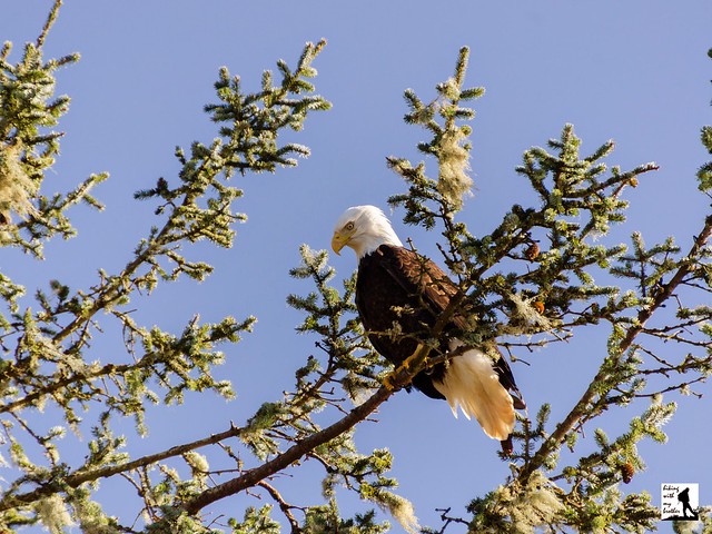
A few weeks ago we took a weekend to head out to the Olympic Peninsula to explore a few hikes along the Pacific Coast. One of those hikes was the very popular Lake Ozette Loop, also known as the Ozette Triangle. This classic hike travels through coastal forests and prairies before reaching a rocky beach filled with marine life and the lingering signs of the people that called this area home for hundreds of years.

Sometime before 1500, the Makah people established five large villages in the northwest corner of the Olympic Peninsula. The largest and most southern of these was named Hosett or Osett, situated near Lake Ozette. The village was sustained by resources from both the lake and the sea, and today’s trail between Lake Ozette and the beach follows roughly the same footpath used by villagers for generations. Hosett was thriving in 1790 when explorer Manuel Quimper named the rocks near the village Cape Punta de Hijosa. It was renamed Punta de Alava in 1794 in honor of Jose Manuel de Alava, who helped broker a peaceful solution to the conflicting claims of Spain and Great Britain over portions of the Pacific Northwest coast. Today the point is known as Cape Alava and has the distinction of being the westernmost point of the contiguous United States, inching out Cape Flattery by just 350 feet.
Europeans continued to settle in the area, and by 1855 the Treaty of Neah Bay was signed, establishing the Makah reservation. However, the Makah in Hosett refused to move to the reservation. To solve the problem, the Ozette Reservation was established in 1893, leading many to mistakenly believe there was a separate Ozette tribe. Around this time, the area around Lake Ozette supported a small Scandinavian population. In 1902, a homesteader named Lars Ahlstrom began working the land between Lake Ozette and the ocean in an area now known as Ahlstrom’s Prairie. In 1907 Peter Roose set up a homestead next to Ahlstrom, in what is now known as Roose’s Prairie. While most of the buildings the homesteaders constructed are gone, the Park Service does maintain a few buildings at the Peter Roose Homestead, now a National Historic site.

Over time those living on the Ozette Reservation slowly left, with the last leaving in 1937. Roose lived on his homestead until his death in 1944. Ahlstrom soldiered on until the early 1960s. In the meantime, the last “Ozette” with any claim to the reservation passed away in 1953 without any heirs, calling into question who owned the 791-acre Ozette Reservation. After long debate and confusion over whether the Ozette Tribe ever existed, the reservation was transferred to the Makah in 1970. Today the entire area is preserved by both the Park Service and the Makah Tribe.
The trail begins from the Lake Ozette Ranger Station, crossing over the Ozette River and entering a forest of wind-blown spruce and mossy cedar. Almost immediately the trail splits. The path to the left will take you out to Sand Point, while the trail to the right leads to Cape Alava. While either works, we recommend heading to the right as there is more to see along this route. The trail is fairly flat, though almost all of the of the trail is dominated by wooden boardwalks designed to keep you out of the mud and marsh. However, as this area gets a great deal of rain, keep in mind that the boardwalks are often quite slick.
After roughly two miles, the forest opens into Ahlstrom’s Prairie, a tree-lined expanse of marsh grasses and salal. Continue across the prairie, and just as you begin to re-enter the forest, keep an eye out for a well-trodden path leading off the boardwalk into a dense stand of trees to the right. A short distance from the main trail find the crumbling remains of a wooden outbuilding left by Ahlstrom. Once you’ve done a little poking around, press onward to the shore.

The trail soon deposits you on the beach. To check out Cape Alava, head north toward the large tree-covered seastack of Tskawahyah Island. Your route will lead you into the Ozette Reservation and past the dilapidated looking Makah Ranger Station. Depending on the tide, you can easily reach the westernmost point of the continental United States by heading to the far side of Tskawahyah Island. Reach it by clambering over the cannonball-shaped rocks, which have led many to refer to it as Cannonball Island. After you’ve done a little exploring, retrace your steps back to the trail and press southward toward Sand Point.
Depending on the tide, hike along the narrow strip of sand between the crashing waves and the headland, or venture onto the rocks to find pools teeming with crabs, anemones and starfish. After 1.2 miles reach the first headland. At higher tides, leave the beach and head onto a short trail over the bluff, which quickly returns you to the beach on the other side. The Wedding Rocks can be found in this area; a series of petroglyphs depicting a variety of images, including a wedding scene, all carved into the rock by the Makah hundreds of years ago. Push onward, crossing rocky, boulder-filled beaches and another headland before reaching the sandy shores near Sand Point. At 1.7 miles from the Wedding Rocks, arrive at the junction with the North Sand Point Trail just shy of Sand Point. If you’re up for a little extra trail time, head past the junction to the tip of Sand Point to catch a glimpse of coastline hidden behind the point. Either way, follow the North Sand Point Trail back into the woods as it makes a bee-line for the Ozette Ranger Station, crossing long stretches of the now-familiar boardwalk along the way.
Boasting dramatic seascapes that attract a wide variety of wildlife, the hike is a popular destination for hikers and backpackers. Permits are required to camp in one of the many campsites along the beach, which are often filled to capacity during the summer. While the hike to the beach is an easy trek with very little elevation change, reaching the trailhead involves quite a bit of effort. For that reason, we recommend you explore the full loop rather than leaving part of the trail for another day. At the same time, even if you only have time to do a portion of this hike, it’s well worth the effort to get there.

To get to there, take the Bainbridge Island ferry to Bainbridge Island. From the terminal, follow SR 305 for 13 miles to SR 3 North. Follow SR 3 to the Hood Canal Bridge, taking a left over the bridge onto State Route 104. Follow SR 104 as it merges onto US 101 and continue 35 miles to Port Angeles taking a left on Lincoln Street. Continue for about 43 miles to the junction with SR 113. Turn right and continue on SR 113 for a little over 20 miles as it changes into SR 112 and travels through Sekiu to reach the Hoko-Ozette Road. Turn left and follow the Hoko-Ozette Road for a little over 21 miles to the Ozette Ranger Station and the trailhead. - Nathan
Print Google Directions >>


 Back in 1983, a winery was built in the area now known as Snoqualmie Point. The Snoqualmie Winery operated until 1997, and allowed its visitors to enjoy expansive views of Mt. Si, Mailbox Peak and Mt. Washington rising over North Bend and the Snoqualmie Valley. After the winery was shuttered, plans were in the works to develop the area into an office park. In response, a group of community leaders including the Mountains to Sound Greenway Trust worked with the City of Snoqualmie to purchase the area in 1999. In 2009, the Washington Department of Natural Resources (DNR) purchased the nearly 11,000 acre Raging River Forest adjacent to Snoqualmie Point, creating a corridor of public forest connecting Rattlesnake Mountain to Tiger Mountain. Today the DNR is still working on developing the recreational opportunities, which are likely to include hiking, biking and equestrian trails.
 If you’re up for some exploration, this is a fun trek through an area that has yet to have official trails built and routed. However, the hike follows a rough mixture of forest roads and mountain biking trails through a working forest, which leaves it a somewhat light on natural beauty. Still, there is enough elevation change on this hike to make it a decent workout, and because it is still undeveloped, you’re unlikely to run into too many other people. Close and easily accessible, the Raging River State Forest is a good alternative to some of the busier trails near North Bend.
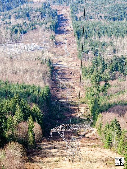
