Total Ascent: 2500ft
Highest Point: 5000ft
Total Distance: 8 miles
Location: N 47° 20.8500, W 121° 18.4380
Required Permit: Sno-Park Permit
Difficulty: Moderate
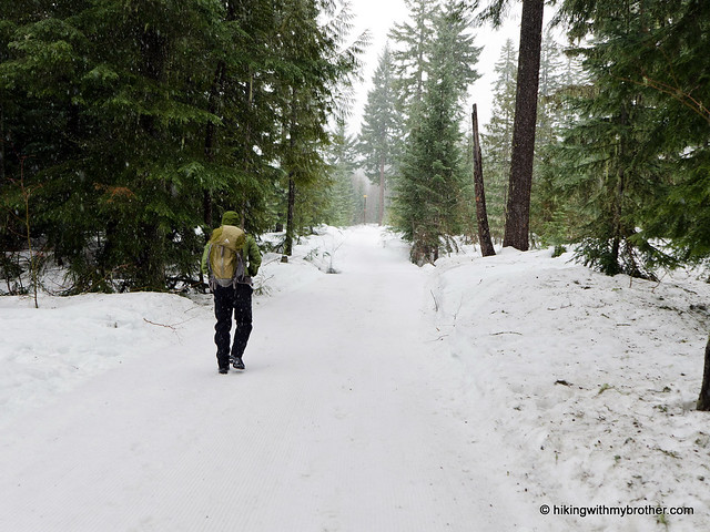
 While there is plenty of good snowshoeing left this season, weather and timing sometimes makes the trek out to the back country a challenge. Since we had the right amount of time and what we thought was a favorable forecast, we headed out over Snoqualmie Pass to a snowshoe route with a little elevation gain and the promise of some views: Keechelus Ridge.
 The ridge overlooks the eastern end of nearby Keechelus Lake. “Keechelus” is a Native word meaning “few fish” or “less fish” in contrast to neighboring Kachess Lake which means “more fish.” Although portions of the ridge are privately owned, national forest roads provide a public route to the summit. In 2007, the Cascade Land Conservancy acquired 320 acres of wildlife habitat on Keechelus Ridge, further expanding the area that you can explore with a sturdy pair of snowshoes.
The trail begins at the Price Creek Sno-Park, cutting up a few hundred feet through second generation firs and cedar to FR 4832. Head left down the wide road and you will soon encounter Price Creek. If you’re already itching for the back country, leave the road here and head uphill parallel to the water, staying high on the bench above the creek. This will shave some distance off the road route. Alternatively continue a short distance to FR 124, which swings wide around Price Creek and slowly switchbacks up the mountainside.
 The road route passes a number of small roads, some private. Stick to the larger, wider FR 124 until you reach a major intersection, likely filled with snowmobile tracks in the winter. The back country route will land you at this same intersection as well. This is FR 4934, and you should expect some company. It is a popular road for snowmobilers, and it’s likely they’ll buzz by you if you stick to the road. Back country folks can walk straight across FR 4934 and continue the charge straight up the ridgeline to the radio tower at the summit. If you prefer the road, angle to the right and uphill on FR 126 and continue to the tower.
While the radio tower is fun for some, most will find bigger rewards from the views here on a clear day. Don’t expect 360-degree views, and do expect to tromp around a bit to get views in different directions. Still, it should be easy to pick out Mt. Rainier in the panorama, seasoned hikers will be able to pick out Chair Peak, Kaleetan Peak, Bandera Mountain, Mt. Stuart, Mt. Defiance, and Granite Mountain. But everyone will be able to enjoy the expanse of snow-covered mountaintops and craggy ridges. Find a good spot sheltered from the snowmobilers and reap the rewards of your climb.
At almost 2,500’ of elevation gain, this is a challenging snowshoe.
 Make sure you save this hike for a clear day, as the views really make this hike worth it. Unfortunately, the weather was not in our favor, and we were shrouded in low-hanging clouds. This limited visibility kept us on the roads rather than venturing into the back country, which not only prevented us from feeling like we’d gotten away from civilization, but also kept us in close contact with snowmobilers. While we went off road on our trek back down, we couldn’t quite escape the noise of the snowmobiles. We recommend tackling this hike on a sunny weekday to minimize the motorized company.
To get there, take I-90 over the Pass to the Kachess Lake Exit 62. Avoid the temptation to take Exit 61, with its alluring “Price Creek Sno-Park” sign, since there’s no way to cross I-90 to get to the trail. Instead, take Exit 62, head left across the overpass and get on I-90 heading west to Exit 61 and the side of Price Creek Snow Park you need. - Nathan