about us | links | permit info
Subscribe to Hiking With My Brother Email Subscribe Follow Hiking With My Brother on Facebook Follow Hiking With My Brother on Twitter Hiking With My Brother Picasa Hiking With My Brother YouTube

Melmont Townsite

Our Hiking Time: 2h
Total Ascent: 100ft
Highest Point: 1360ft
Total Distance: 2.5 miles
Location: N 47° 1.8360, W 122° 1.9980
Required Permit: None
Difficulty: Easy

Nathan's Photo
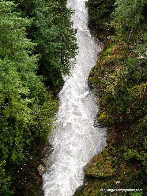
As we continue hiking Washington’s mountains and forests, we often find ourselves running into pieces of the past. The state is riddled with crumbling buildings, abandoned towns, and former railroad hubs. Recently, we decided adding a few more ghost towns to the blog would be fun and so we packed up and headed out to the town of Melmont to see what we could find.

If you’re looking for a short stroll through Washington’s history, Melmont is a good choice. Other than the short drop down to the railroad grade, which could be tricky for some very young hikers, the trip out to the town site is very easy. melmont ghost town hikingwithmybrother At the same time, there is not much in the way of serious hiking. You can extend your hike a bit to push down to the river, but other than that, we are not sure there is much more to see. We recommend this hike for those interested in ghost towns or those looking for a quick winter adventure.

There's a lot more to Melmont Townsite, and you can learn all about it in our book, Hiking Through History Washington.  You'll find a trail map, route descriptions, history, and more for this and many more hikes throughout the State. Help support hikingwithmybrother.com and the work we do by picking up a copy!

To get there, take I-5 South to I-405. From I-405 take SR 167 south toward Auburn. In 20 miles take the SR 410 Exit toward Sumner/Yakima. Follow SR 410 for 12 miles to SR 165. Take a right and continue on SR 165 for about 10 miles through Carbonado to the Fairfax Bridge. A small gravel turnout on the far side of the bridge provides parking. Hike back across the bridge and head toward the rock wall. Hop the guardrail to find a rough path down to the railroad grade. -Nathan

Print Google Directions >>

Melmont Ghost Town

Green Mountain - Kitsap Peninsula - Gold Creek Trailhead

Our Hiking Time: 2h
Total Ascent: 1000ft
Highest Point: 1680ft
Total Distance: 5.0 miles
Location: N 47° 33.7860, W 122° 48.4620
Required Permit: Discover Pass
Difficulty: Easy

Nathan's PhotoAs we continue down a new trail each week, we often find ourselves going further and further east. To change things up a bit, we looked west across the Sound to see if there were any day hikes within easy reach. We quickly found Green Mountain State Forest tucked just outside of Bremerton.

Green Mountain State Forest boasts a 13-mile network of multiuse trails attracting over 50,000 hikers, bikers, campers and equestrians annually. However, it is a “working forest” managed by Washington’s Department of Natural Resources (DNR). Like most of the land under DNR management there is often some sort of resource extraction going on, most commonly timber harvesting. Fortunately, the area encompasses nearly 6,000 acres, making it unlikely that you’ll run into active logging, though the DNR will occasionally close sections of trail to the public while work is being done.

green mountain state forest hikingwithmybrotherWe began from the Gold Creek Trailhead following the Gold Creek Trail toward the summit of Green Mountain, hoping for some good views. The short trek down wide, well-maintained trails took us through a young forest full of the rhododendron we so often see on this side of the Sound. As we neared the top, we took a moment to look down on Lake Tahuya through a break in the trees. Noticing what seemed like a more direct route following some power lines up the mountainside, we couldn't resist a little adventure. One word of caution, however: we’re not sure if the lines are still electrified, but they are very close to the ground in places, so watch your step.

Once you’ve reached the vista, take some time to look around for various breaks in the trees. Depending on which directions you're looking, a sea of trees stretches toward nearby Gold Mountain, Hood Canal, and the skyscrapers of Seattle. Further afar, snowcapped Olympics line the western horizon. After you’ve gotten your fill of views, you have some options. If you’re still yearning to stretch your legs, you can extend your hike, heading out to Green Mountain Horse Camp or exploring the popular Beaver Pond Trail. Or if that's too much, you can also add a little more mileage by returning to the trailhead via the Plummer Trail.

Green Mountain State Forest is a great place to explore if you like Mt. Si and Tiger Mountain but are looking for a change of scenery. The elevation gains are modest and approachable for nearly every hiker. And, while there is certainly some motorized traffic in the form of motorcycles and green mountain state forest hikingwithmybrotherATVs, much of that activity is concentrated on the Wildcat side of the forest. It’s close and fairly accessible, making this a good choice for younger hikers.

To get to the Gold Creek Trailhead, take the Bremerton ferry to Bremerton. From the terminal, follow Kitsap Way for three miles. Bear left on Northlake Way for a little over a mile to Seabeck Highway. Veer left and continue for three miles to Holly Road. Turn left and follow Holly Road a little over four miles to Tahuya Lake Road. Again turn left, and continue for a little over a mile to Gold Creek Road. Veer left and find the Gold Creek Trailhead on the left in two miles. -Nathan

Green Mountain
Copyright 2008-2016 - hikingwithmybrother.com
hikingwithmybrother@gmail.com