Total Ascent: 500ft
Highest Point: 6,011ft
Total Distance: 7.0 miles
Location: N 47° 2.7540, W 121° 29.5500
Required Permit: None
Difficulty: Easy
 A few months ago, back before the autumn leaves fell and the winter snows settled in, we were planning a hike out toward Mt. Rainier along Highway 410. With relatives in tow we wanted a hike that was not too difficult, but would also offer a destination with some good views. After doing a little research, we settled on the well-trodden Noble Knob trail, which proved to be the perfect choice.
Noble Knob is perched at a high point along the Dalles Ridge. It is named for the Nobel firs that would cover the summit if
 they had not all been burned in forest fires. Over the years, the area around Noble Knob has seen its fair share of fires, including a large burn in 1890. The exposed ridgeline and prolific wildflowers are a lasting legacy of those fires. A fire cabin was constructed on Noble Knob in 1934, shortly after another wildfire ravaged the area in the 1920s. Evidence of that forest fire and the newly-constructed cabin can be seen in this 1934 photograph looking southwest from Noble Knob. More evidence of the fire is shown in photographs taken looking to the north and southeast. The cabin was destroyed in 1954 and was not replaced, probably because other towers had been constructed nearby.
There is a trailhead at either end of the Noble Knob Trail #1184, one from Corral Pass and another off of Twentyeight Mile Road (FR #72). The Corral Pass approach has a more developed trailhead, whereas the Twentyeight Mile Road approach has paved portions that make access a little bit easier on your vehicle. We opted for Corral Pass mostly because it’s by far the more popular of the two.
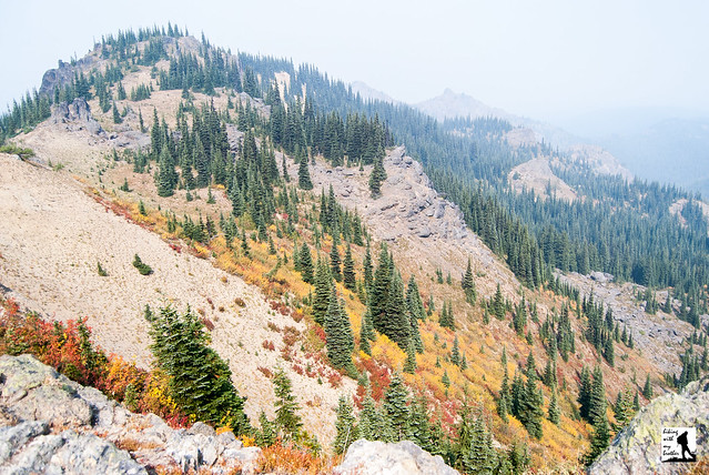
From the Corral Pass Trailhead the route begins mildly, alternating between roadbed and trail while wandering through meadows and sparse stands of fir and pine. During the late spring, these areas are bursting with wildflowers, and in the fall the underbrush is a sea of reds, oranges, and yellows. The first mile or so is more or less flat, quickly transporting you to your first glimpses of snow-covered Mt. Rainier at roughly a mile and a half from the parking lot. As you gain the ridgeline and traverse along the southern shoulders of Mutton Mountain the trail continues to open up while skirting the edge of the Norse Peak Wilderness to the north.
 Just before the two-mile mark you will reach a junction with the Deep Creek Trail #1196. Stay to the right and continue following the ridgeline as the trail turns north continuing to parallel the Norse Peak Wilderness to the west, ever so briefly entering it for a few moments two and three-quarters of a mile from the trailhead. You’ll know you went through the Wilderness when you encounter the junction with the Dalles Ridge Trail #1173 at three miles. Head right, staying on the Noble Knob Trail to the next junction in a tenth of a mile. Here the trail splits in three directions. The path to the right is the Lost Lake Trail #1185, leading into the Wilderness and to the shores of Lost Lake. The trail to the left heads out to the other end of the Noble Knob Trail and the alternative trailhead, as well as a side trail leading down to Twentyeight Mile Lake. To reach the summit, take the middle path straight up to the top.
As you climb, the views only improve. Catch glimpses of Lost Lake to the west, and Twentyeight Mile Lake to the east. There is some confusion around the name of this lake – some USGS maps label it Twentymile Lake. Most likely the product of a typographical error somewhere along the line, the official name for this little lake is Twentyeight Mile Lake. Before you know it you will have reached the top and its 360-degree views. Mt. Rainier seems almost close enough to touch. Look north for your first view of George Lake in the meadow-filled cirque below you. Forested peaks spread out in every direction. Find good place to settle in and enjoy the views.
 This is an ideal trail to introduce anyone to hiking in Washington – whether you’re bringing the little ones, encouraging friends to get outside, or entertaining relatives in from out of town. It is a rare trail that can deliver such spectacular views with only 500ft of elevation gain. This ease of access does make Noble Knob a very popular destination during the hiking season, so expect to be sharing the trail and the views with other hikers and mountain bikers. Keep in mind that all this traffic churns up the trail, making it a hot and dusty hike in the summer. The possibility of crowds aside, we recommend everyone put this on their hiking list to tackle in the near future.
To get there, take I-5 south to Highway 18, Exit 142A. Follow Highway 18 into Auburn and take the SR 164 exit. Head left on SR 164 through Enumclaw to SR 410. Head left onto SR 410 and continue 31.2 miles through the town of Greenwater to the Corral Pass Road #7174 on the left. Follow #7174 for 6.7 miles to the signed trailhead and a small parking area. Additional parking can be found a tenth of a mile further down #7174. -Nathan
Print Google Directions >>