about us | links | permit info
Subscribe to Hiking With My Brother Email Subscribe Follow Hiking With My Brother on Facebook Follow Hiking With My Brother on Twitter Hiking With My Brother Picasa Hiking With My Brother YouTube

Moss Lake Natural Area

Our Hiking Time: 1h 30m
Total Ascent: 100ft
Highest Point: 600ft
Total Distance: 3.7 miles
Location: N 47° 41.5860, W 121° 51.0300
Required Permit: None
Difficulty: Easy

Nathan's Photo
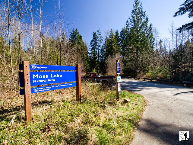
A few months ago we took some time to trek through the Moss Lake Natural Area, one of many designated Natural Areas in King County. Although the hiking is limited to a single trail, the low elevation of Moss Lake lets you  make a quick escape into the woods at any time of year.

Located between Carnation and Duvall, the 372-acre Moss Lake Natural area is relatively new, with the last portions of the park purchased in 2002. The area is named for the sphagnum peat bog that surrounds Moss Lake. The lake itself is very shallow, not more than 20 feet deep, and is thought to be mostly man-made, a legacy of the peat that was excavated from the bog early in the 20th century. That peat moss was sold and likely found its way into local gardens and planting beds. A moss-drying plant was constructed in the 1920s, but quickly burned down leaving the area untouched until the mid-1950s when preparations began to setup a peat mining operation which never fully materialized. By the 1980s little remained of the past mining activity beyond a sunken peat dredge and a few cabled logs. King County bought most of the land in 1990, seeking to protect one of the only peat bogs in the county. By 2002 the last parcels were secured and the area was developed for recreational use.

The trail begins from the parking lot and quickly leads you through the wetlands to the shores of Moss Lake. About half the natural area is wetlands, home to a variety of animals including bald eagles, beavers and pileated woodpeckers. It’s not uncommon to see a great deal of wildlife from the marshy shores, so spend some time quietly enjoying the lake. When you've had your fill, continue onward through brushy wetlands along trails lined with salmonberry and sword fern. Before long the trail begins to climb, entering into a mixed forest of second-growth alder and hemlock that provides a nice contrast to the wetlands below.  Where the trail splits you can choose either direction of the loop to tackle first.  Either way you go, you'll eventually encounter the gated edge of the Moss Lake Preserve, as shown on the Moss Lake Trail Map.  Beyond is a maze of forest roads that wander through forests owned by Hancock Forest Management.  Hancock has imposed fees for hikers to access some of their other holdings in Washington State, but it's not clear that a permit is required here.  We recommend you skip the gate and keep this hike short and continue following the short loop within the Natural Area.

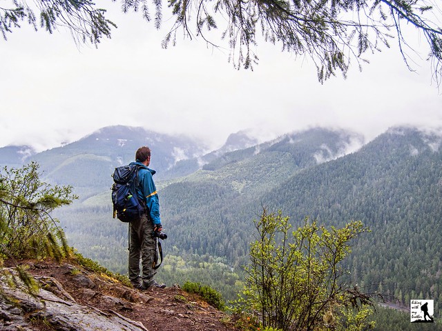
This little hike works well for a quick hike or if you’re looking for a causal hike with friends or little ones. Although short, Moss Lake manages to pack a lot of variety into a small amount of space, quickly taking you from marshy lakeshores to forested wetlands and up into second growth forest. There’s enough elevation to make the hike interesting, and because Moss Lake is relatively unknown, you’re unlikely to run into too many other people on the trail. Next time you’re looking for something a little different, give Moss Lake Natural Area a try.

To get there, take SR 520 out to its end and continue straight on Avondale Road. After a mile veer right onto Novelty Hill Road. Continue on Novelty Hill Road until it ends at a T-intersection with Snoqualmie Valley Road. Take a left and almost immediately take a right onto 124th Street. 124th connects with SR 203, also known as the Fall City Duvall Road. Take a right and continue for 3.8 miles to Stillwater Hill Road. Take a left and follow the road as it becomes Kelly Road. At just under 2 miles, veer right onto Lake Joy Road. Stay on this road for 2.5 miles as it curves around Lake Joy to Moss Lake Road. Take a left onto Moss Lake Road and find the Moss Lake Natural Area parking lot in a half-mile. -Nathan

Print Google Directions >>

Moss Lake Preserve

Palisades Trail #1198

Our Hiking Time: 4h 10m
Total Ascent: 2100ft
Highest Point: 4400ft
Total Distance: 8.8 miles
Location: N 47° 2.2560, W 121° 32.8800
Required Permit: Northwest Forest Pass
Difficulty: Moderate

Nathan's Photo
We’ve spent a lot of time in the Highway 410 Corridor in the last few months, exploring both popular and less-travelled trails. This week was no exception. Following the promise of big views of the White River Valley, we decided to take on the Palisades Trail #1198, which climbs up into the rocky cliffs above Snoquera Falls.

The cliffs surrounding Snoquera Falls and rising above Camp Sheppard were likely named “palisades” for their resemblance to castle walls. There are a number of places in Washington dubbed “palisades” for this reason. You can read more about this history of this area in our post on Snoquera Falls.

The trail begins right from the highway, and wastes little time drawing you up and away from the noise. Almost immediately you will arrive at a junction with the White River Trail #1199. Keep left, following the Palisades Trail as it begins to tackle the mountainside in earnest. Following Dalles Creek, the route soon beings switchbacking up the narrow canyon through lush forest. As you climb, watch the underbrush of salal and salmonberry slowly give way to a moss-covered forest floor. A great deal of trail work has smoothed out the scree that used to be a larger problem in the first mile of trail.

Your first destination is Lower Dalles Falls, a crashing wall of water tumbling down a wall of rock. Trees obscure the top of the falls, but a short side trail allows for a closer look. Even up close you cannot get a full view of the 280ft falls, but that doesn’t stop the falls from being pretty impressive anyway. Keep in mind that this is a snow-driven creek, and in the high summer it is not much more than a glorified trickle. If you want a big show, late spring and early summer are the best time to visit. The area around the falls is also home to another often mentioned highlight of this hike - Calypso orchids, which can be found along the trail leading up to the falls during the spring months. The small, delicate flowers can be a little hard to spot if you’re not looking for them.

Push past the falls, up the wooden staircase and continue to switchback up toward some more level ground. Cross Dalles Creek and enjoy this section of level trail. Before long, at about the 2.5 mile mark, you’ll reach the first viewpoint along the trail. This is the lowest and least expansive view of the surrounding landscape, but also makes for a decent stopping point for those looking for a shorter day. Sun Top Mountain is almost directly across from you and depending on the time of year, you can pick out Skookum Falls across the valley.

If you decide to push on, you will soon be traveling through old growth, gradually climbing another mile to the next viewpoint. From here the views are impressive. Mt. Rainier and Sun Top Mountain rise above the valley. Looking southeast you can see your final destination; a rocky outcropping further down the ridge, offering commanding views of the landscape.

Press onward, following the trail as it veers away from the cliffs and briefly passes through a section of young forest still recovering from a recent harvest before dipping down and crossing Snoquera Creek. Once across, the final lookout is within reach, and before long you’re looking for a comfortable place to settle in and soak up the view. For those looking for an even longer day, you can press on to the Ranger Creek Trail #1197 for access to Little Ranger Peak and perhaps the Ranger Creek Shelter beyond. You can also push past the shelter to connect with the Noble Knob Trail #1184. From that junction it’s a quick jaunt past Twentyeight Mile Lake and up to the top.

This is an excellent trail especially in the late spring when the wildflowers are popping up and Lower Dalles Falls is really flowing. The variety of stopping points along the way also makes dealing with lingering snow a little easier. If late snow is too much after the first viewpoint, you’ve at least gotten a taste of the hike. This is fairly popular hike, and because it connects with a number of other trails, it is also one often used by mountain bikers. The trail is a little steep for some, but reaching the first viewpoint should be attainable for most hikers. With summer not yet in full swing, we recommend you try this steady climb through old growth to big views of Mt. Rainier soon.

To get there, take I-5 south to Highway 18 Exit 142A. Follow Highway 18 into Auburn and take the SR 164 exit. Head left on SR 164 through Enumclaw to SR 410. Head left onto SR 410 for 26.8 miles to a dirt pullout on the left side of the highway, a quarter-mile past the Skookum Falls viewpoint. The trail begins here at a small signed trailhead. -Nathan

Print Google Directions >>

Palisades

Whitehorse Trail to Darrington

Our Hiking Time: 5h 10m
Total Ascent: 100ft
Highest Point: 500ft
Total Distance: 10.6 miles
Location: N 48° 16.5648, W 121° 42.3517
Required Permit: None
Difficulty: Easy

Nathan's Photo
A few months ago, we were looking for a low elevation hike to explore while waited for the snows to recede from the mountaintops. After some consideration, we headed north to wander down a portion of the Whitehorse Trail, a rails-to-trails project that follows a railroad spur that once ran between Arlington to Darrington.

In 1901, the Northern Pacific Railroad finished laying down nearly 30 miles of track out to Darrington, and that same year the first train arrived ready to haul freshly mined ore back to Arlington and eventually Everett. However, the mines overpromised and under-delivered, and soon ore gave way to trains nearly overflowing with timber. Over the years, nearly a dozen small sawmills cropped up along the route, with many eventually developing into station stops that each have their own little slice of history. After Darrington struggled through the Great Depression, the timber helped fuel the town’s post-war boom.

But timber sales eventually began to wane. By the 1980s, planners began to eye the underused railroad as a possible recreation site, modeling a proposal based on other rails-to-trails projects like the Iron Horse Trail. In 1991, the railroad – today known as the Burlington Northern Santa Fe (BNSF) – formally abandoned the route and in 1994 work began to remove the tracks. After about two decades of work, today less than 6 miles of the 27-mile trail are officially open to the public, mostly due to lack of funds necessary to make the 16 bridges and other structures along the corridor safe for public use. And the name? That’s taken from the prominent Whitehorse Mountain the hike treks past, which was named in 1894 by W.C. Hiles, Darrington’s first postmaster, for the image of a horse he saw outlined in the snow as it melted each spring.

Although you can start on either end of this trail, we recommend hiking from Swede Heaven Road toward Darrington. From the Swede Heaven Trailhead, the trail begins on a quiet neighborhood street, and wanders into a mixed forest following the North Fork Stillaguamish. The river, though sometimes obscured behind a thin wall of trees, makes a pleasant walking companion as you continue down the graveled railbed. The hike will take you over streams, across roads, and through Darrington Bluegrass Music Park’s amphitheater where you can catch views of Whitehorse Mountain looming nearby.

Around the half-way point, you’ll reach Riverbend, where the North Fork Stillaguamish peels away from the trail and the trees open up for views of the mountains to the north, including Mt. Higgins, Round Mountain, and North Mountain. If you’re looking for a shorter day, follow the trails leading down to the river for a decent picnic location. But, if you’re looking for more, continue onward, passing through a swath of powerlines and into the most remote section of the trail. Enjoy a mile or so of quiet forest before encountering the edges of a logging operation. Find the other end of the trail not too long after.

This is a great choice for an off-season hike. Flat and wide, it’s approachable for any hiker and is also popular with bikers. While most of the trail abuts backyards, logging mills and other trappings of civilization, the occasional views are good and sections of trail do manage to feel like you’re deeper in the forest than you are. If you’re looking for more adventure, the Snohomish County Park Service clears out the rail corridor between Arlington and Swede Heaven Road every year, making it easier for folks to cautiously explore the roughly 20 miles of trail still officially closed to public use.

To get there, take I-5 north to Exit 208 and drive east on SR 530 22.5 miles to Swede Heaven Road. Take a left and find the trail a half-mile down the road. There is a small amount of parking here, otherwise head back out to SR 530 to find parking. If you prefer to start in Darrington, continue on SR 530 into Darrington to Railroad Avenue. Take a left and find the trailhead and a small parking lot at the end of the road. -Nathan

Print Google Directions >>

Whitehorse Trail
Copyright 2008-2016 - hikingwithmybrother.com
hikingwithmybrother@gmail.com