Total Ascent: 3800ft
Highest Point: 5723ft
Total Distance: 8 miles
Location: N 48° 4.1340, W 121° 28.2600
Required Permit: Northwest Forest Pass
Difficulty: Hard
 This week we continued our exploration of the Mountain Loop Highway by tackling Mt. Dickerman, one of the area’s more challenging trails. The trail promised an easily accessible trailhead and breath-taking views. And it delivered.
 Mt. Dickerman was named after Alton L. Dickerman, a mining engineer who was sent to assess the Monte Cristo area in 1891. His analysis helped a group of investors convince Nelson Rockefeller to back a mining venture, which spurred the development of the Monte Cristo Mining District. Ultimately becoming a Trustee of the Monte Cristo Mining Company, Dickerman remained connected to the troubled mining region until his death in 1921.

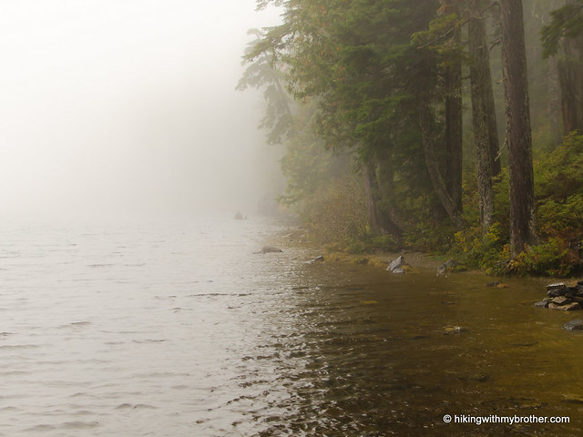
The Mt. Dickerman Trail #710 begins at the Dickerman/Perry Creek trailhead just off the Mountain Loop Highway. From the onset, this trail is an uphill battle, quickly rising away from the highway in a long series of tight switchbacks. The route tunnels through thick, mixed forest of maple, hemlock, and fir. Streams occasionally cut across the path, and the trail often brushes near waterfalls and creeks just off-trail. With nearly 4000’ of elevation to climb up, these little side attractions make for great stopping points along the way.
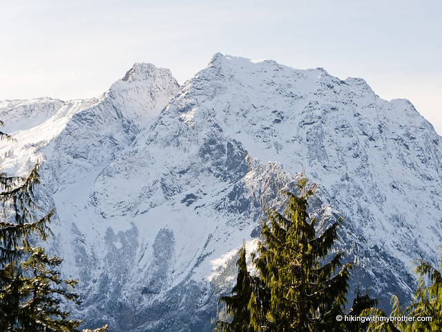
 After about three miles of switchbacks, the trail transitions from dark forest to open alpine meadows that hint at views to come. In the spring and summer months, this area is awash in wildflowers and mountain blueberry. After this brief respite, the trail gains the ridgeline and presses upward to the summit. Navigate this next set of switchbacks and before long you’ll find yourself on a precipice, looking hundreds of feet down into the Perry Creek Valley. Tread carefully and find a spot to take in the 360-degree views. To the north pick out Mt. Baker and White Chuck Mountain rising above nearby Mt. Forgotten. As you turn east Mt. Sloan looms large next to Glacier Peak, Mt. Pugh, and Bedal Peak. Mt. Rainer can be seen to the south behind Del Campo Peak, Vesper Peak, Big Four Mountain, and Morningstar Peak. Mt. Pilchuck and The Three Fingers are to the west.
 We highly recommend adding a trip to Mt. Dickerman to your hiking list. On a good day the views from the summit are stunning. Mountains stretch out endlessly in every direction, and it’s easy to see why hikers trudge their way to the top of Mt. Dickerman year-round. While trail is a little rocky, hundreds of booted feet keep the route free of blow downs and overgrowth. Only the steep elevation gain might keep this hike a little out of reach for some. Still, the trail is in good enough condition that most hikers should be able to make it given enough time.
To get there, take I-5 North to Exit 194. Follow Highway 2 for about two miles. Stay in the left lane and merge onto Lake Stevens Highway 204. Follow for two miles to Highway 9. Take the left onto Highway 9 toward Lake Stevens. In just under two miles, you’ll reach Highway 92 to Granite Falls. Take a right and follow for about nine miles to the Mountain Loop Highway. Take the MLH for a little over 27 miles to the Dickerman/Perry Trailhead on your left. – Nathan
Print Google Directions >>
 Almost every weekend for years, we have been trekking down hiking trails across Washington and reporting our findings on