about us | links | permit info
Subscribe to Hiking With My Brother Email Subscribe Follow Hiking With My Brother on Facebook Follow Hiking With My Brother on Twitter Hiking With My Brother Picasa Hiking With My Brother YouTube

Dingford Creek Road to Trailhead #1005

Our Hiking Time: 3h 30m (on bikes)
Total Ascent: 700ft
Highest Point: 1440ft
Total Distance: 11.5 miles
Location: N 47° 31.0440, W 121° 27.2400
Required Permit: None
Difficulty: Easy

Nathan's Photo
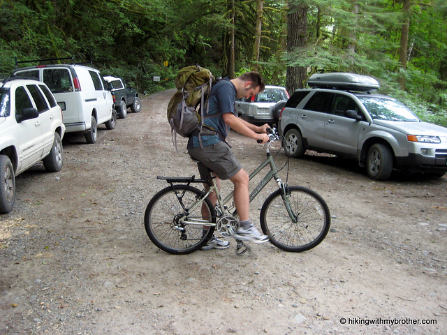
Occasionally, after flipping though guidebooks and finding a hike we want to do, we’ll find that conditions have changed and many miles of road walking are now necessary to access a suddenly distant trailhead. Not easily deterred, this week we came up with a creative solution to our dilemma: incorporating mountain bikes into our hike to cut down time spent plodding down forest roads! Wanting to experiment with the concept before fully committing ourselves to a bike-hike, we decided to head out the Middle Fork Snoqualmie Valley and test out a currently closed section of Forest Road 56 leading out to the Dingford Creek Bridge.

Typically, a high-clearance vehicle can drive FR 56 to the dingford creek hikingwithmybrotherDingford Creek Trailhead, however, washouts have temporarily closed the road just across the Taylor River. Fortunately, volunteers working at the Goldmyer Hot Springs still have access to the now locked gate allowing supplies and manpower in and out of the area with relative ease. Currently, efforts are underway to repair this portion of FR 56, but no firm schedule has been determined. We were assured by the Forest Service that the road would open up soon, perhaps as early as this fall.

Our bike trip out to the trailhead was more difficult than we had anticipated. Rocky washouts created troublesome obstacles and unexpected inclines slowed our pace. While the bike ride made short work of friendly sections of the forest road, we found ourselves pushing our bikes up hills and rocky gullies. The scenery was pleasant enough, with maples, alders and ferns lining the roadside. However, by the time we reached our destination, we’d easily expended as much energy as we would have walking the road.

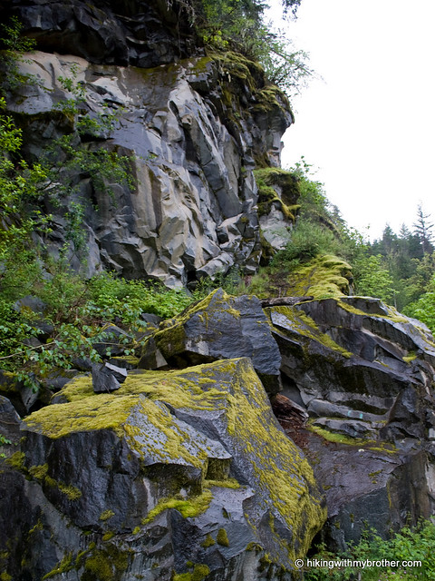
Once at the trailhead, we tromped down to the Taylor River to check out the Dingford Creek Bridge. This turned out to be a pleasant little spot, with more than enough room to support a few campsites. Crossing the bridge connects with the Middle Fork Snoqualmie Trail #1003 and access to Goldmyer Hot Springs. Find a path down to the riverside and enjoy a snack.

Hauling the bikes out to Dingford Creek really helped us to realize how much we prefer hiking to biking.

Had the road been in great shape, we might have had an easier time of it, but as it turned out, we ultimately decided that bike-hikes were best left to better-maintained roads, which might leave us with some energy for the climb up. Hikes such as Hester and Myrtle Lakes – both accessible from the Dingford Creek Trailhead – are still on our list, we’ll just have to leave the bikes behind and plan for a longer day. To get there, take Exit 34 off I-90 and take a left on 468th Ave. Follow the road past the truck stop for about a half-mile until you reach SE Middle Fork Road, also known as Forest Road 56. Continue to follow the twists in the road until the pavement runs out. Continue on FR 56 for 12 miles, crossing the Taylor River. Once across, FR 56 veers to the right while the Taylor River Road continues another quarter mile to the Snoqualmie Lake Trailhead. Find a spot to park at the gate and hit the trail. -Nathan Dingford Creek

CCC Trail #1264 to Nordrum Fire Lookout Site

Our Hiking Time: 3h 15m
Total Ascent: 700ft
Highest Point: 1500ft
Total Distance: 6 miles
Location: N 47° 32.2440, W 121° 34.5240
Required Permit: Northwest Forest Pass
Difficulty: Easy

Nathan's PhotoA few weeks ago, we found some extra time to wander down the most well maintained portion of the CCC Road Trail. In the past, we hiked the wilder sections of this former logging road, so to finish it out, we returned to the Middle Fork Snoqualmie Valley to explore its final leg and visit a former fire lookout site; Nordrum Lookout.

The trail abruptly begins off FR 56, without so ccc road trail hikingwithmybrothermuch as a widening in the road for parking. If you decide to start at this end of the trail as we did, try to find an unobtrusive place to park nearby. A small sign marks the “trailhead.” The path leads into a mossy mixed forest of alder, hemlock and cedar. Streams and rivulets frequently cross the trail, and occasionally the canopy opens up to reveal views of Mt. Garfield and Russian Butte. Unlike other sections of the CCC Road Trail, trail #1264 often wanders away from the old roadbed, crossing boardwalks and bridges erected over small streams and swamps. We passed by volunteers working to keep the trail in good shape – a stark contrast to other portions of the trail which are rocky, overgrown, and washed out.

The CCC Road as a long history that we have previously related, beginning with its Depression-era construction to its current recreational usage. Anyone who has ever camped at the Middle Fork Campground has probably taken a stroll down this gentle trail, but relatively few have followed the faint, mostly overgrown path up to the old Nordrum Lookout site.

ccc road trail hikingwithmybrotherThe lookout began in 1934 as a cabin on a recently logged hillock that suddenly found itself with an expansive view of the Middle Fork Valley. Within a few years, a tower was added, presumably to stay ahead of the rapidly recovering vegetation. By the 1950s, other lookouts on much taller perches made Nordrum obsolete, and the site was dismantled. Today, there is little more than a clearing with moss-covered foundation stones protruding with rusted metal.

While the route to the lookout site is unsigned, it is easily located. There is only one major junction on the trail, found just before reaching the Middle Fork Campground. Continuing straight will lead to the campground, while veering to the right will take you back to FR 56 and the Middle Fork Trailhead parking lot. Instead, take a left up the hill following the faintest of paths through the ferns to the lookout site. It is a short jaunt uphill to stand on a little ccc road trail hikingwithmybrotherpiece of history.

This hike is easily approachable for just about anyone. Very little elevation gain makes this a nice stroll through the woods, and lends an appreciation of what the Middle Fork has to offer. The hike up to the lookout site is more challenging, but it is also very short and makes a great little side trip for those itching to pull a little extra out of this hike. Although this portion of the CCC trail is on the tame side, it manages to do the best job of showcasing the natural beauty of the area.

To get there, take I-90 to exit 34 and take a left onto 468th Ave. Follow the road past the truck stop for about a half-mile until you reach SE Middle Fork Road, also known as Forest Road 56. The road has a few twists and turns, but continue onward until the asphalt ends at Mailbox Peak Trailhead. Press on for just over 10 miles to the trailhead or 12 miles to Middle Fork Campground, both on the left. -Nathan

CCC Trail North

Perseid Meteor Shower from Tiger Mountain

Nathan's PhotoEvery year the Perseid meteor shower brightens the summer sky. At the suggestion of a reader, we decided to do a midweek night hike and enjoy the show. Wanting a familiar trail for this adventure, we returned to tiger mountain cable line hikingwithmybrotherour old training grounds, the Tiger Mountain Cable Line. Just as the sun was setting, we dug out our headlamps and headed back out to Exit 20.

“Perseids” as the meteors are known, are so named because they seem to originate from the constellation Perseus. The meteors are the remnants of the comet Swift-Tuttle, which crosses the Earth’s orbit every 130 years on its way around the Sun. As the Earth travels through the comet’s dust and debris field, meteorites hit the atmosphere and streak across the night sky.

The Cable Line is still the same, and we found no reason to revise our previous review of the trail. In retrospect, hiking up the steep, slippery trail in the middle of a hot summer night was not ideal. Instead, we probably should have taken the longer and better-maintained West Tiger #3 trail to the top. As it turned out, we spent more time than expected navigating portions of the trail made more challenging by the lack of light. On the upside, it was impossible to see how much more uphill remained ahead of us, which might have helped us tackle the elevation a bit easier.

tiger mountain cable line perseid hikingwithmybrotherOnce at the summit, we settled down to try to capture an elusive Perseid. We knew we were not nearly far enough away from the city to fully escape the light pollution, but in the shadow of the mountain we were able to see more than a few Perseids streak across the sky. Surprisingly, in contrast to the dozens of cars at the bottom, only one other hiker was there to share in the show.

Although night hiking can be a little tricky, and is definitely more difficult than hiking during the day, it was fun to hike up and see the meteors. If ever you’re tired of your favorite trail, break out the headlamp and try a night hike; you’ll see it in a whole new way. - Nathan

Tiger Mountain Cableline

Rooster Mountain - Quartz Creek Trail #1263

Our Hiking Time: 5h
Total Ascent: 2800ft
Highest Point: 4000ft
Total Distance: 9 miles
Location: N 47° 34.8060, W 121° 32.8200
Required Permit: Northwest Forest Pass
Difficulty: Moderate

Nathan's PhotoFor months, we have talked about tackling Rooster Mountain, a sizable peak in the Middle Fork Snoqualmie Valley that would yield some new and interesting views of the surrounding landscape. Always just over the horizon, it often came up as a possible hike, but we wanted to wait for the snow to fully retreat and a nice sunny day to attempt it. The stars aligned this last week and we packed up and headed back to the Snoqualmie Lake trailhead and Rooster Mountain.

Technically, Rooster Mountain is the unofficial name for a 5,339’ prominence between the Quartz Creek Valley and Marten Lake. There is nothing particularly Rooster-esque about the mountain, instead it seems to have fallen victim of an animal naming craze that swept the area at some point. Nearby Goat Mountain and Dog Mountain must have been christened by the same barnyard animal lover. Each of these three peaks extends a ridgeline down to a central point between Mowitch, Marten, and Cougar Lakes. While some resources refer to Rooster Mountain as “The Ark,” the unnamed central point between Rooster, Goat and Dog Mountain seems a more apt place to point out the abundance of animal-themed topography.

The trail begins at the Snoqualmie Lake trailhead, following #1002 to for about a half-a-mile to the Quartz Creek junction. Take the eroding and extremely rocky logging road up past occasional views of the steep-sided Quartz Creek Valley to an unsigned spur road at the two-mile mark. This junction is large and impossible to miss. Continuing on the road will take you to Blethlen Lakes, choosing the rougher, steeper spur will take you toward to Rooster Mountain. The former road to Rooster Mountain becomes progressively more trail-like as trees and underbrush close in and narrow the path. After another two miles and three large switchback the trail forks once again. The path to the left is the now-overgrown and largely inaccessible trail to Rooster Mountain summit, while the path to the right leads to the road’s end and a nice little viewpoint. Sadly, like others before us, we were forced to settle for the viewpoint.

This hike was a good reminder of what hikingwithmybrother.com is all about. Guidebooks are an excellent resource, but all too often they are woefully out of date, and it falls to the hikers on the ground to publish updates on the condition of any given hike. Despite being a guidebook favorite, cropping up in several different publications, there is no trail to the summit of Rooster Mountain. The old bootpath has been largely reclaimed by the forest. Of course, you can still bushwhack your way to the top, or snow could provide an easy path over the blocking vegetation. But, if you’re expecting a trail, your hopes will be dashed roughly three-quarters of the way to the top.

On the upside, the 4,000’ viewpoint isn’t bad. It sports an impressive, if somewhat limited, view of the valleys below, including Bessemer Mountain, Russian Butte, Mount Garfield – as well as Rooster’s elusive summit. And, if isolation is what you’re looking for, Rooster Mountain is a great option: very few hikers attempt this trail. On the other hand, reaching our stopping point is a significant amount of effort that might be better spent climbing to other heights. If you are training for a bigger climb, or have the time to hack your way to the top, give Rooster Mountain a try. Otherwise, we recommend skipping this one for greener pastures.

To get there, take Exit 34 off I-90 and take a left on 468th Ave. Follow the road past the truck stop for about a half-mile until you reach SE Middle Fork Road, also known as Forest Road 56. Continue to follow the twists in the road until the pavement runs out. Continue on FR 56 for 12 miles, crossing the Taylor River. Once across, keep to the left for another quarter mile to the end of the road and the trailhead. -Nathan

Rooster Mountain
Copyright 2008-2016 - hikingwithmybrother.com
hikingwithmybrother@gmail.com