about us | links | permit info
Subscribe to Hiking With My Brother Email Subscribe Follow Hiking With My Brother on Facebook Follow Hiking With My Brother on Twitter Hiking With My Brother Picasa Hiking With My Brother YouTube

Olallie State Park

Our Hiking Time: 1hr
Total Ascent: Negligible
Highest Point: 1200ft
Total Distance: 0.5 miles
Location: N 47° 26.2800, W 121° 39.3000
Required Permit: Discover Pass
Difficulty: Easy

Nathan's PhotoWe took some time recently to tie up some loose ends around Olallie State Park. While we’d seen Twin Falls, we had not fully explored the rest of the park, which promised more trails, cliffs, and waterfalls.

weeks falls olallie state park hikingwithmybrotherFinding a reliable route over the Cascades to connect Seattle with the rest of the state was an early goal of Seattle’s founders. After numerous surveys and more than a little help from Snoqualmie guides, a trail was established over what would later be known as Snoqualmie Pass. By 1865 efforts were underway to expand the trail enough to support wagon traffic. Known as the Snoqualmie Pass Wagon Road, it opened in 1867 and was the first in a long series of road-building projects eventually culminating the I-90 freeway. The short trail to Weeks falls hugs the South Fork Snoqualmie River, travelling over the lingering traces of that long abandoned wagon road. The first portions of the park were acquired back in 1950, and given the name “Olallie” a Chinook jargon term for “berry,” a nod to the proliferation huckleberries found in the park during the summer months.

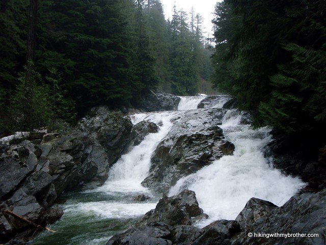
Weeks Falls, like Twin Falls, is now the site of a hydroelectric plant, though less effort has gone into concealing the facilities. One perk of visiting in the winter months was the high water levels, which made this 60ft cascade a little more exciting. The plant pumps out a little over 4 megawatts a year, enough to power about 800 homes.

olallie state park hikingwithmybrother Rock climbers flock to Olallie for the expansive climbing walls, most of which are located just above the Iron Horse Trail. An unmarked trail up to the climbing area begins at Change Creek, winding up the mountainside to the old railroad grade. The path begins by following the creek but quickly delves deeper into the woods, past boulders and exposed rock. Ahead, a railroad bridge spans Change Creek and eventually you find yourself passing the girders holding it aloft. The cliffs, known as Deception Crags are impressive, are impressive and full of climbers year-round. Just across the bridge is the fledgling Hall Point - Change Creek Trail which eventually winds its way up to the top of Mt. Washington, and is a nice alternative to the traditional route.

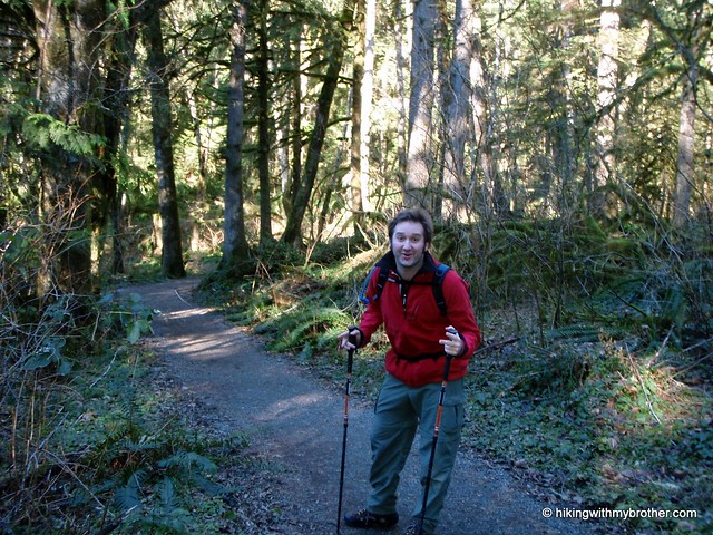
We’d recommend exploring this portion of Olallie State Park while visiting Twin Falls, perhaps taking the Iron Horse Trail between the two points. However, if you’re short on time or have some toddlers or need some additional accessibility, Weeks Falls is a nice place to visit on a jaunt out of the city.

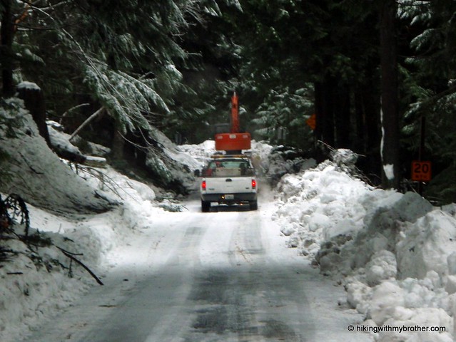
To get there, take Exit 38 off 1-90. Head left and follow the road for about a half-mile until you see the signed parking lot on your left. -Nathan

Print Google Directions >>

Olallie State Park

Mt. Si - Haystack Scramble

Our Hiking Time: 4h 15m
Total Ascent: 3500ft
Highest Point: 4160ft
Total Distance: 8 miles
Location: N 47° 30.4020, W 121° 44.3700
Required Permit: Discover Pass
Difficulty: Hard

Nathan's PhotoWe were in the car bright and early, cruising on I-90 out to the hike we’d carefully selected after researching closures and avalanche conditions, when the sunlight caught us. Nosing out from behind the Cascades, it lit up the foothills and danced off the snow nearly blinding us. It was only then did we notice that there was not a cloud in the sky, and that the day was going to be gorgeous. Our hike looked to be sheltered and was unlikely to give us any good opportunity to take advantage of a rare cloudless winter day. Looking to our left we could see Mount Si had lost all the snow of the Haystack we’d noted last weekend, so we decided to chance it. Carpe diem.

Just like Little Si, Mount Si is named for a local settler Josiah mt. si haystack hikingwithmybrother"Uncle Si" Merritt, though it had a name before then: Kelbts. The mountain features prominently in the Snoqualmie myth around the origin of fire. Fox and Blue Jay follow a cedar rope into the sky, where they trick Moon, known as Snoqualm, and steal the Sun from him. Fox returns from above bringing trees for the Cascades and placing the Sun in the sky. Enraged, Moon chases them down the rope only to have the rope break and tumble to the ground becoming Mount Si. It is said Snoqualm’s face can still be seen in the rocks of Si.

Mount Si is incredibly popular, with a monstrous parking lot marginally able to service the 100,000 annual visitors to the trailhead. During our training for Rainier last year, we braved the crowds and maneuvered our way to the top, but that experience made it clear that it would be tricky to navigate the trail with so many people and all of our gear. This does not stop the thousands of others who utilize the rigorous 4-mile ascent to the base of the Haystack in their endurance training for larger peaks.

Partly because of the popularity, every half mile of this route is marked, letting you know how much you’ve got left to go. However, probably due to the number of people scuttling past the mile markers, about half of them have been ripped off, leaving only a forlorn post, perhaps a mt. si haystack hikingwithmybrotherscraggly nail, and if you’re lucky, a handwritten validation of your progress. The trail is almost entirely an uphill slog, broken up by two plateaus that act as rest areas. As you follow the switchbacks up first through scattered alder stands which then give way to second generation cedar and Douglas fir, you’ll first reach what Manning refers to as the “cliff viewpoint” with benches provided. Pushing past this, at the rough halfway point, you’ll reach the appropriately named Snag Flats, where dedicated trail volunteers built a boardwalk in 1994 to highlight one of the very few survivors of the 1910 Mount Si Fire: a 350 year old Douglas fir.

The trail itself is well-worn from all those feet, and fairly wide, if a bit rocky at times. We passed two trail loop options, the Talus Loop and Canyon Loop, which could offer some variety for the jaded Si climber. Past the three-mile mark snow began to appear and we were forced to slow down and tread more carefully. Upon reaching the Haystack Basin it was apparent that there would be snow on the Haystack, but with the skies still clear, we wanted to investigate anyway. The scramble to the top is very steep and requires a good grip on the rocks to hoist yourself up. There was quite a bit of snow, but it was melted enough to allow us access to the rocks, which hundreds of other hands have already tested to find firm and sturdy hand-holds. With a bit of struggle, we had our reward. A 360-degree panorama with visibility for dozens of miles – we could easily pick out Mt. Washington, Teneriffe, Rattlesnake, and Rainier to the south and east. To the west loomed the Olympics, as well as downtown Seattle, Bellevue and, as you swiveled north, Everett and Mt. Baker.

Getting down can be a bit hard on the knees, but the reward was mt. si haystack hikingwithmybrothermore than worth the trip and the somewhat harrowing scramble. That scramble up the Haystack pushed us into the hard category, though the hike up to the Basin, while a workout, is achievable by most folks if taken at a reasonable pace. Alternatively, if you'd like something a little more challenging and less crowded, you can take the Old Trail to the Basin.

To get to Mount Si, you can take one of two exits off I-90. The traditional way is Exit 31, and heading into town past the outlet malls for about a mile until you hit North Bend Way and take a right. Alternatively, you can skip the crowds and take Exit 32 at 436th Ave. Again, you’ll head to the left into town and again hit the same North Bend Way, which you’ll take a left on. Either way you’re quickly going to come upon Mt. Si Road. Take Mt. Si Road for about two miles, first passing over the Middle Fork Snoqualmie, and then passing the Little Si parking lot, until reaching the well-signed Mount Si lot on the left. Hopefully there is a spot for you to park and head on up. - Nathan

Print Google Directions >>

Mount Si

Best of Hiking with My Brother (so far)

As we push into the double-digits with our hikes, we wanted to highlight our favorite. However, despite lengthy discussion, we were unable to come to a consensus on the matter, ultimately narrowing it down to two hikes. Tiger, Squak, and Cougar we immediately put out of the running, a combination of over-familiarity with the trails and the encroachment of housing developments into the scenery. Cedar Butte, Rattlesnake and Little Si are great hikes, but again, we have visited all of these with some regularity in the past, making it hard for the experience to really resonate with us. Annette Lake is the only alpine lake we've visited, but the amount of rain and snow coming down really soured the journey for us. Both Dirty Harry's Peak and Mailbox Peak are really great hikes, but because both are pretty difficult, much of our focus and attention was on getting one foot in front of the other, rather than taking in our surroundings.

This left us with Mt. Washington, which I was rooting for, and Twin Falls, Jer's favored hike. In the end, rather than trying to resolve our impasse, we decided to just talk about both.


Nathan's Photo
Nathan's Pick - Mt. Washington

Given the set of hikes we've done so far, Mt. Washington really hits the right note with me. It's a decent length, it's just hard enough to be engaging, but not so difficult you cannot enjoy the trees going by, and your hard work is rewarded at the top. Moreover, it's far enough out that you can escape from housing and the crowds, yet you can get to the trail head from downtown Seattle in about a half-hour. Finally, the trail itself is refreshingly varied; the path takes you through an engaging landscape past lakes, streams and rivers, second and third generation forests, and also offers the opportunity to see the impacts of past logging on a landscape. Then there is the view. Jer has somehow forgotten the unique and stunning view of Rainier over the Cedar River Watershed that this hike provides. This is the backdrop to the little alpine meadow at the top making it ideal for a small picnic, especially in the spring when the wildflowers are in bloom.

Accessible, engaging, and rewarding: Mt. Washington is easily a better trail experience than Twin Falls. Jer is absolutely right - I'm going to point out that Twin Falls is crowded. We were there in the dead of winter and ran into dozens of people and the parking lot was overflowing when we left. We met just a handful of other hikers on Mt. Washington and it was never intrusive or unpleasant. I'll grant that the falls themselves were great to see, and I'm glad we got to see them with relatively little human traffic in the snowy landscape. However, it's very short, designed to convey one to the waterfall as quickly as possible, which makes the walk to the falls feel like a chore, something to be done with so one can take in the main attraction. Out of the hikes we've done so far, I've recommended Mt. Washington repeatedly to friends, and I do it again now: if you're looking for a great casual hike, you can't miss with Mt. Washington.


Jer's PhotoJer's Pick - Twin Falls

Twin Falls stands out as my favorite of the last ten hikes because it can be accomplished by hikers of all skill levels, but doesn't shortchange you on the natural beauty that can be seen in the Pacific Northwest. The trail literally touches the shores of the South Fork of Snoqualmie River, which means there's plenty of opportunities for hitting the ice cold water on a hot summer day. To top it all off, only a mere mile and quarter walk from the trailhead, you can reach the lower observation deck where you will be face-to-face with the gushing 135ft tall cataract that is Lower Twin Falls. Feeling a little more adventurous? Then just continue walking past the falls and you will eventually join up with the Iron Horse trail, where you'll have easy access to all that Olallie State Park has to offer.

I agree with Nathan in that Mt. Washington is a great hike and you should definitely put it on your to-do list. However, first I suggest you forgo the "opportunity" to see the impacts of logging, and instead enjoy the grandeur of the 14ft diameter stands of old growth forest that you will see inside Twin Falls State Park. Sure, Mt. Washington has its views, but so does almost every other summit that we recently climbed. And unlike Washington, your enjoyment of this hike will not be interrupted by losing the path down an old logging road because you overlooked a haphazardly placed rock cairn. Nathan will probably try to argue that this hike will be swarming with people, but as with many outdoor destinations in close proximity to Seattle, there is a optimal time that you should go. Do this hike in the winter off-season or on a weekday and you will not be disappointed.

Little Si Trail

Our Hiking Time: 1h 40m
Total Ascent: 1100ft
Highest Point: 1576ft
Total Distance: 4 miles
Location: N 47° 29.9220, W 121° 45.3780
Required Permit: Discover Pass
Difficulty: Moderate

Nathan's PhotoHiking in the winter always has a few unexpected hiccups. Despite having made sure to review closures on the Department of Transportation site, and despite having reviewed avalanche warnings, weather, and local conditions, we still ran into a surprise on our way to our selected hike. The narrow forest road we were on was entirely blocked by construction crews clearing debris, forcing us to throw it into reverse for a full mile. This left us without much of a plan so we decided to make the best of it and visit an old friend, Little Si.

little si hikingwithmybrotherLittle Si crouches in the shadow of Mount Si’s western slopes, both edifices named in honor of Josiah "Uncle Si" Merritt, who set up a cabin at the base of Si in 1862. Until 1985, when Will Thompson and friends blazed new trail and revamped the existing scramble to the summit, Little Si was the province of scramblers and adventuring types. In 1989, the 28.2 acre Little Si Natural Area was acquired by King County and infrastructure improvements have continued since that time, including dedicated parking areas and the shift of the trailhead further away from private property. With this most recent visit, we took note of additional parking that seems nearly ready for public use, which will help take some pressure off the existing lot which is almost always overflowing.

little si hikingwithmybrotherOver the years, perhaps because of these improvements, Little Si has become increasingly popular, and you can expect to meet plenty of company on the trail. The short hike up to the top is pleasant nonetheless, beginning with a moderate grade and continuing up into thick stands of second generation forest. The trail winds beneath this canopy until it is broken by the rocky overhangs frequented by climbers. A number of spurs split off from the main trail to the base of these cliffs, allowing you a few more places to explore on the way back down. Switchbacks become more common as you near the top, while the trees open up to reveal views of Si and the haystack. The rocky summit will likely be occupied, but as you jockey for a view, you’ll see North Bend spread out below, Rattlesnake Mountain dominating the skyline to the south, and Mt. Washington marking the beginnings of the Cascades to the southeast.

Little Si is close, easily accessible, and just hard enough to feellittle si hikingwithmybrother like a hike, yet still gentle enough for the whole family. While not exactly high adventure, it was good to go back and see how things have progressed; most notably the old truss bridge that long spanned the Middle Fork Snoqualmie has vanished, replaced by the new bridge that had been in progress for years. To get there take I-90 to Exit 31, taking a left into town. Navigate the roundabout and outlet mall traffic until you get to North Bend Way, and take a right and head north to Mount Si Road (aka 432nd NE) on the left. Keep an eye out for this one, it comes up fast. Once you’re on the road, follow it about a mile, going over the bridge and attempt to find a spot in the lot you’ll see on the left. - Nathan

Print Google Directions >>

Little Si

Twin Falls to Iron Horse Trail

Our Hiking Time: 3h
Total Ascent: 900ft
Highest Point: 1360ft
Total Distance: 4 miles
Location: N 47° 26.7420, W 121° 42.1800
Required Permit: Discover Pass
Difficulty: Easy

Nathan's PhotoThe high tide of the holidays finally began to recede with the New Year. We’ve been so awash with friends, family, and holiday traditions that we wanted to keep it short and simple this week. With bigger adventures on the close horizon, we settled on exploring the Twin Falls Natural Area, a short hike just off the interstate - famed, according to Mr. Manning, for being the “toddler-friendliest” path in the I-90 corridor.

twin falls hikingwithmybrotherMuch of this landscape has changed since old US10 was the primary thoroughfare for Snoqualmie Pass. The Twin Falls Recreation Area was the first of four parcels that now comprise Olallie State Park, acquired by the Parks Department in 1950 as plans were finalized for early phases of present day I-90. What was a short pullout and trail to the falls overlook on US10 became isolated with the advent of the new freeway. Despite the successful efforts to preserve the land as parkland, access to the falls nonetheless languished. Then, in the early 1980s, the Weeks Falls Hydroelectric Project just upriver from Twin Falls was brought online. This was followed swiftly by a project for Twin Falls, which ultimately led to the rebuilding of the trail in late 1989, as well as the helicopter-assisted bridge construction.  However, all of the Twin Falls hydropower workings are underground or underwater, hidden from view.

The path begins gently, hugging the banks of the South Fork Snoqualmie River for just under a mile before starting a series of ups and downs.  The rushing river is your friendly companion as you press toward the falls through a young forest of pine and alder.  Find the path down to the lower falls near the two mile mark.  It is a short 104 steps down to a the observation deck to take in the stunning cascade and look up at the 80’ bridge spanning the river. Beyond the bridge, the trail winds up to an overlook of the upper falls before ptwin falls hikingwithmybrotherushing onward to connect up with the John Wayne Pioneer Trail.

Accessible year round, this approachable trail is ideal for little hikers, as the falls make for a dramatic end to the hike.  At the same time, because it is so easily accessible, it's a very popular trail, so you can expect some company on this little walk in the woods.

To get there, take Exit 34 off I-90 and take a right. Follow 468th Ave until just before the steel truss bridge where a tiny brown sign reading “Twin Falls” directs you to take a left on 159th St. Follow this for about a half a mile to the trailhead. - Nathan

Print Google Directions >>

Twin Falls
Copyright 2008-2016 - hikingwithmybrother.com
hikingwithmybrother@gmail.com