


Total Ascent: 3500ft
Highest Point: 4160ft
Total Distance: 8 miles
Location: N 47° 30.4020, W 121° 44.3700
Required Permit: Discover Pass
Difficulty: Hard
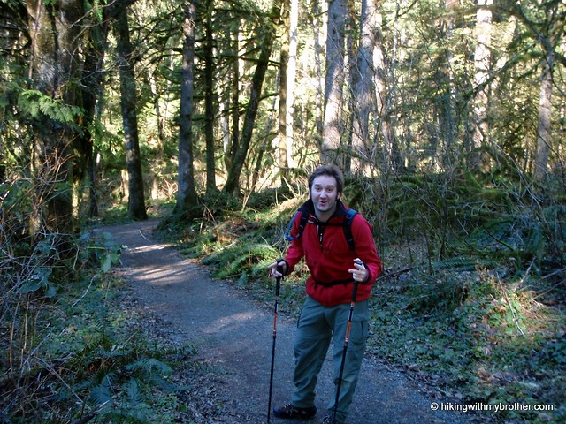
 We were in the car bright and early, cruising on I-90 out to the hike we’d carefully selected after researching closures and avalanche conditions, when the sunlight caught us. Nosing out from behind the Cascades, it lit up the foothills and danced off the snow nearly blinding us. It was only then did we notice that there was not a cloud in the sky, and that the day was going to be gorgeous. Our hike looked to be sheltered and was unlikely to give us any good opportunity to take advantage of a rare cloudless winter day. Looking to our left we could see Mount Si had lost all the snow of the Haystack we’d noted last weekend, so we decided to chance it. Carpe diem.
Just like Little Si, Mount Si is named for a local settler Josiah
 "Uncle Si" Merritt, though it had a name before then: Kelbts. The mountain features prominently in the Snoqualmie myth around the origin of fire. Fox and Blue Jay follow a cedar rope into the sky, where they trick Moon, known as Snoqualm, and steal the Sun from him. Fox returns from above bringing trees for the Cascades and placing the Sun in the sky. Enraged, Moon chases them down the rope only to have the rope break and tumble to the ground becoming Mount Si. It is said Snoqualm’s face can still be seen in the rocks of Si.
Mount Si is incredibly popular, with a monstrous parking lot marginally able to service the 100,000 annual visitors to the trailhead. During our training for Rainier last year, we braved the crowds and maneuvered our way to the top, but that experience made it clear that it would be tricky to navigate the trail with so many people and all of our gear. This does not stop the thousands of others who utilize the rigorous 4-mile ascent to the base of the Haystack in their endurance training for larger peaks.
Partly because of the popularity, every half mile of this route is marked, letting you know how much you’ve got left to go. However, probably due to the number of people scuttling past the mile markers, about half of them have been ripped off, leaving only a forlorn post, perhaps a
 scraggly nail, and if you’re lucky, a handwritten validation of your progress. The trail is almost entirely an uphill slog, broken up by two plateaus that act as rest areas. As you follow the switchbacks up first through scattered alder stands which then give way to second generation cedar and Douglas fir, you’ll first reach what Manning refers to as the “cliff viewpoint” with benches provided. Pushing past this, at the rough halfway point, you’ll reach the appropriately named Snag Flats, where dedicated trail volunteers built a boardwalk in 1994 to highlight one of the very few survivors of the 1910 Mount Si Fire: a 350 year old Douglas fir.
The trail itself is well-worn from all those feet, and fairly wide, if a bit rocky at times. We passed two trail loop options, the Talus Loop and Canyon Loop, which could offer some variety for the jaded Si climber. Past the three-mile mark snow began to appear and we were forced to slow down and tread more carefully. Upon reaching the Haystack Basin it was apparent that there would be snow on the Haystack, but with the skies still clear, we wanted to investigate anyway. The scramble to the top is very steep and requires a good grip on the rocks to hoist yourself up. There was quite a bit of snow, but it was melted enough to allow us access to the rocks, which hundreds of other hands have already tested to find firm and sturdy hand-holds. With a bit of struggle, we had our reward. A 360-degree panorama with visibility for dozens of miles – we could easily pick out Mt. Washington, Teneriffe, Rattlesnake, and Rainier to the south and east. To the west loomed the Olympics, as well as downtown Seattle, Bellevue and, as you swiveled north, Everett and Mt. Baker.
Getting down can be a bit hard on the knees, but the reward was
 more than worth the trip and the somewhat harrowing scramble. That scramble up the Haystack pushed us into the hard category, though the hike up to the Basin, while a workout, is achievable by most folks if taken at a reasonable pace. Alternatively, if you'd like something a little more challenging and less crowded, you can take the Old Trail to the Basin.
To get to Mount Si, you can take one of two exits off I-90. The traditional way is Exit 31, and heading into town past the outlet malls for about a mile until you hit North Bend Way and take a right. Alternatively, you can skip the crowds and take Exit 32 at 436th Ave. Again, you’ll head to the left into town and again hit the same North Bend Way, which you’ll take a left on. Either way you’re quickly going to come upon Mt. Si Road. Take Mt. Si Road for about two miles, first passing over the Middle Fork Snoqualmie, and then passing the Little Si parking lot, until reaching the well-signed Mount Si lot on the left. Hopefully there is a spot for you to park and head on up. - Nathan
Print Google Directions >>
2 Comments:
Hey, brothers Barnes! I went to Si proper for the first time today. Just wanted to let you know that I used the blog to get a feel for what I'd be doing. Very different conditions (snowy, misty, no visibility...) than when you were there almost 2 years ago, but your descriptions were still helpful. Thanks!
Great site you have here. Will definitely use it for selecting hikes in future.
I also hiked Mt Si a few weeks back. Was a little overcast so visibility was not too far but still beautiful views from the top. Will do it again when the weather clears up.
Post a Comment