Total Ascent: 2300ft
Highest Point: 5600ft
Total Distance: 8.8 miles
Location: N 47° 29.6400, W 120° 50.1540
Required Permit: Northwest Forest Pass
Difficulty: Moderate
 Last week, during the final gasps of summer, we geared up for our last backpacking trip of the season. Our destination was the popular Colchuck Lake, a dazzling alpine lake at the foot of Aasgard Pass and the Enchantment Lakes Basin. With snow in the forecast we headed into the mountains hoping for a last day of blue skies before winter settled in. As luck would have it, we beat the snows by a day.
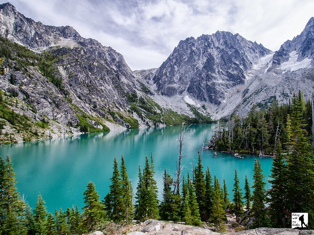
 Colchuck Lake is nestled in a rocky cirque beneath a trio of craggy mountains – Enchantment, Dragontail and Colchuck Peaks – and plays host to multitudes of hikers every year. While many know that ‘colchuck’ means ‘very cold water’ or ‘ice water’ in Chinook Jargon, far fewer are aware that the glacier-filled lake acts as a irrigation reservoir for nearby farmers and residents. Back in 1926, a severe drought highlighted the need to supply water to Leavenworth and the surrounding areas during dry spells. Within a few years, the Icicle and Peshastin irrigation districts had come together with a plan to dam alpine lakes to act as reservoirs. Four lakes were ultimately chosen to supplement seasonal water flows: Colchuck, Eightmile, Klonaqua and Square lakes. By 1930, a dam was constructed at Colchuck Lake, and today’s trail likely follows a route blazed for the construction of that dam. In 2005, the dam began to fail causing the lake level to fall dramatically. Repairs the following year returned the lake to its familiar reservoir levels. Today, Colcuck Lake is part of an irrigation system that includes 60 miles of canals supplying water to over 8000 acres of farmland and orchards.
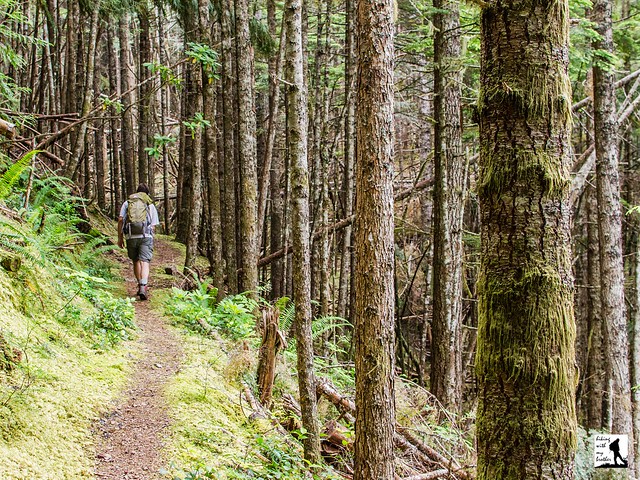
 The Stewart Lake Trail #1599 begins by following Mountaineer Creek into a mixed forest of alder and pine. Within a quarter-mile the trail crosses gently into the Alpine Lakes Wilderness and the canopy slowly opens as you pass through talus fields and across log bridges. The rushing sounds of the creek remain a fairly constant companion as you steadily gain elevation along the hard-packed trail increasingly lined with Lodgepole and Ponderosa pines. At about the two-mile mark find the junction with the Colchuck Lake Trail #1599.1 (sometimes referred to as #1599A) and head left to push up toward the lake.
From the junction, the once-friendly trail becomes steep, rocky, and difficult. Rocks and roots dominate the trailbed, and tight switchbacks become common. As you navigate tricky sections of trail, keep an eye out for reasons to stop and catch your breath. You’ll cross Mountaineer Creek on a large log bridge, and soon after have a pocket-view of Colchuck Peak rising in the distance. Beyond, splashing waterfalls and broad vistas beg for a moment’s pause. As you near your destination, cross exposed granite faces and find yourself inexplicably descending dozens of feet of hard-earned elevation before beginning the final set of switchbacks up to the lakeshore.
Eventually, the trail spills out onto granite bluffs high above the north end of the lake, quickly showcasing the rocky spires that surround the blue-green lake. Across the water Aasgard Pass beckons from the low saddle between Enchantment Peak and Dragontail Peak. Further on Colchuck Glacier clings to the side of Colchuck Peak, slowly feeding the lake below. Press onward along the lake shore to find access to the shore or a suitable campsite. A designated day use area can be found next to Little Colchuck Lake a half mile down the trail.
Still thirsty for adventure? The trail continues around the lake and snakes up Aasgard Pass and into the realm of the gods: the Upper Enchantment Lakes Basin. But a word of warning; this approach is not for the inexperienced. The route is steep and can be treacherous under certain conditions, as most of the trail is comprised of boulder and scree. Be sure you know what you’re doing, and unless you have a lot of experience and training, avoid an ascent in the snow.
 It’s no surprise that this eye-popping alpine lake is incredibly popular. If the stunning lake color set against a dramatic backdrop of mountaintops were not enough, the quick “backdoor” approach the Enchantment Lakes Basin provides more than enough enticement to backpackers. The rough and rocky route can be difficult, and will challenge some hikers. At the same time, this trail makes for a great backpacking destination for those looking for a training hike. If you haven’t already, find time to tackle this classic hike.
To get there, take US 2 to Leavenworth. Just before you enter town, take a right onto Icicle Creek Road (FR 76). Follow Icicle Creek Road for just over eight miles to Eightmile Road (aka FR7601). Turn left and follow the gravel road over Icicle Creek for about 4 miles to the road’s end and the parking area for Colchuck Lake and Lake Stuart. Trailhead at the far end of the lot. -Nathan
Print Google Directions >>