Our Hiking Time: 5h 10m
Total Ascent: 2100ft
Highest Point: 4570ft
Total Distance: 9.5 miles
Location:
N 47° 17.5980, W 121° 15.6720
Required Permit: Sno-Park Permit
Difficulty: Hard

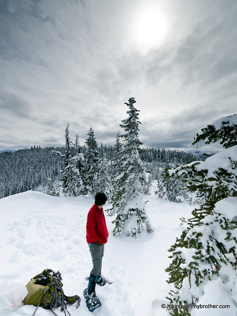
A rare break in cloud cover found us scrambling for a snowshoe route with promises of a view. After checking out the avalanche danger, we settled on Amabilis Mountain, an isolated prominence just beyond Snoqualmie Pass.
Amabilis Mountain looks over Kachess Lake, somewhat isolated and disconnected from the nearby massive ridgeline that ends with Keechlus Ridge. While we were unable to track down the origin of the name, “amabilis” is Latin for “lovely” or “loveable” and the mountain certainly lives up to that description. Then again, it’s also possible that it was named for the abundance of Pacific Silver Fir (abies amabilis) that covers the mountainsides. In either case, the route is accessed via the Cabin Creek Sno-Park and one of the more popular cross-country skiing destinations in the Snoqualmie Pass area. Probably for this reason, Amabilis is often overlooked as a snowshoe route.

Begin by finding a spot to park in the Cabin Creek lot, and gearing up. Hold off on strapping on the snowshoes however, as the trail begins on the opposite side of the freeway, requiring a short jaunt across the overpass to get started. Most likely the trail will be groomed, and you’ll have plenty of company. The first task is to navigate the maze of ski loops to get on the path to the summit. Keep to the right following the signed Berg route for about a quarter-mile until you encounter signs pointing uphill to Amabilis.
The route follows FR 4822 as it slowly switchbacks up the mountain. In the summer, most vehicles can navigate this well-maintained road nearly to the summit. While the skiers are confined to the groomed trail, there’s plenty of opportunity to forge uphill and shave some distance off the long switchbacks - keep a look out for gullies and open areas to take advantage of. At the same time, some sections of Amabilis are extremely steep, and it might make more sense to stick to the road in those areas. At 1.5 miles, do keep a look out for Toll Creek, which can be used to cut out nearly a mile of forest road.

After a little over two miles, the grooming ends and the trail forks. Either path will take you to the summit, though the shorter and more popular choice veers to the left. If you head left as we did, you’ll break trail or follow the path of those that came before you for about a half-mile to a small widening in the road, signed “FR 123” on the left side of the trail. You can cut out three-quarters of a mile of forest road by taking a shortcut up through the pines and taking in some of the views along the way as the trees begin to thin. Once you regain the road, you’re about a mile from the summit.
Forge onward, passing another widening offering excellent westward views of Kachess Lake a little before you reach the top. Press on to enjoy views of Kachess Ridge to the north, rising above Kachess Lake. To the south, a sea of ridges and mountains spread out toward Mt. Rainier. To the northwest, the jagged peaks of the Three Queens and Chikamin Ridge stand out against the skyline. Rest up so that you can enjoy breaking new trail on the way down if you choose to go cross-country.

This is a somewhat difficult snowshoe, one that can be made even more challenging by leaving the forest road in favor of the back country. Whether you prefer the road or the untamed powder, you cannot escape some company at lower elevations, which fades as you push upward. Overall this was a rewarding snowshoe, eventually yielding spectacular views and solitude. The area could definitely benefit from a dedicated snowshoe route, but as it is, it’s still well worth the trip. One note: the lot is a little too small to support the vehicle traffic on the weekends, so try to get an early start.
To get there, take I-90 to the Cabin Creek Exit, #63. Take a right and find parking in the lot. -Nathan


 The park is very popular for biking and trail running, so be prepared to share the trail – though we only saw a few folks on our walk. The main Pipeline Trail is wide and flat, making it possible to bring the whole family out, stroller and all. If you’re looking for new places to bring the dog, this is a good option as well. On the other hand, there is relatively little actual hiking in the park, so those looking for a good hill climb should avoid this one.
 for this and many more hikes throughout the State. Help support hikingwithmybrother.com and the work we do by picking up a copy!