about us | links | permit info
Subscribe to Hiking With My Brother Email Subscribe Follow Hiking With My Brother on Facebook Follow Hiking With My Brother on Twitter Hiking With My Brother Picasa Hiking With My Brother YouTube

Lord Hill Regional Park

Our Hiking Time: 2h
Total Ascent: 350ft
Highest Point: 600ft
Total Distance: 3.6 miles
Location: N 47° 50.8440, W 122° 2.9760
Required Permit: None
Difficulty: Easy

Nathan's Photo
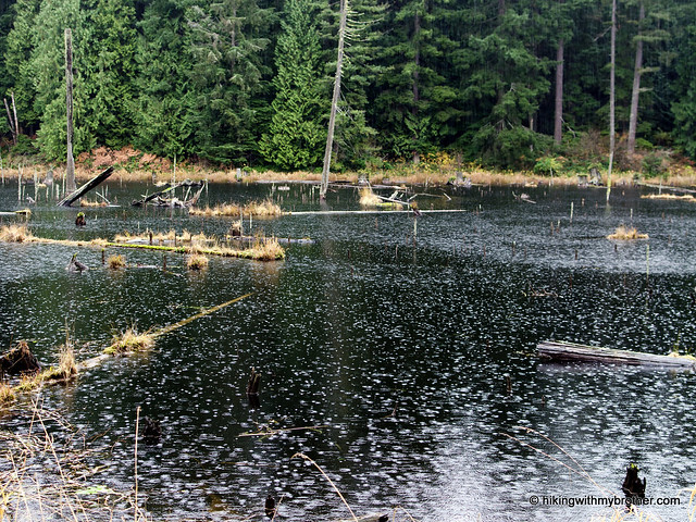
Recently, we found some time to visit Lord Hill Regional Park, a 1,300-acre park in Snohomish County. With over 11 miles of walking trails so close to the city, we took a little tour to see what the park had to offer.

The park is a decent hiking destination during the winter. It’s close and easily accessible, but still large enough to feel like you’re getting out into nature. During warmer weather, this is a great place for youngsters to get out into the woods for the day,lord hill regional park hikingwithmybrother but be prepared to share the mixed use trails with mountain bikers and equestrians. All in all, it’s worth an afternoon to trek out to explore Snohomish County’s largest park.

There's a lot more to Lord Hill Regional Park, and you can learn all about it in our book, Hiking Through History Washington.  You'll find a trail map, route descriptions, history, and more for this and many more hikes throughout the State. Help support hikingwithmybrother.com and the work we do by picking up a copy!

To get there, take SR 522 north toward Monroe. Take the Monroe W Main Street exit and circle around the roundabout to head west on 164th Street. Follow this road for about three-and-a-half miles as it changes from 164th to the Old Snohomish-Monroe Highway to 127th Ave SE. Turn left and continue for a mile-and-a-half to 150th St SE. Take a right and find parking at the end of the road. –Nathan

Print Google Directions >>

Lord Hill

Pinnacle Peak aka Mt. Peak aka Mt. Pete Trail

Our Hiking Time: 1h
Total Ascent: 1000ft
Highest Point: 1800ft
Total Distance: 2 miles
Location: N 47° 10.4220, W 121° 58.4040
Required Permit: None
Difficulty: Easy

Nathan's PhotoTime is often short around the holidays. It can be tricky to wedge a hike between visits to family and friends. We managed to find enough time to climb to the top of an old favorite, just outside of Enumclaw. Although we first knew the small summit as Mount Pete, it’s also known as Mount Peak, Pinnacle Peak, and most recently the Cal Magnusson Trail. No matter which name you prefer, this short-but-steep hike is perfect for a quick winter workout.

pinnacle peak mt pete mt peak hikingwithmybrotherWhile Pinnacle Peak is the official name of the 256-acre King County Park that encompasses the small mountain, there is some confusion over the “real” name of the peak. The Harvey Manning school advocates for Mount Pete, named after Pete Chorak, a Yugoslav émigré and businessman who settled in Enumclaw in 1911. Chorak donated land for a park, and founded the town pool; Pete’s Pool, which later became the city’s stadium. At some point, locals began referring to the mountain as Mount Peak. Our research did not dig up a reason for this switch, though one theory is that “Pete” sounds a lot like “Peak,” suggesting that the latter could have just been born in conversation. When King County bought the first sections of the mountain in the 1980s, the name Pinnacle Peak seems to have risen in prominence, though the fire lookout that stood there from 1928-1971 is always referred to as the Pinnacle Peak Lookout. In 2009, the trail to the summit was dedicated to Cal Magnusson, a Cascade climbing legend, who began maintaining the trail in 1975.

The trail begins steeply from the trailhead, switchbacking up the mountainside, through alder, cedar, and hemlock. From the outset, the plethora of trailside projects hints at the popularity of the trail. Platforms, benches, stairs, railings, nature signs are all here, maintained by a dedicated group of volunteers. Through their efforts the trail is wide, clear of brush, and easy to navigate.

pinnacle peak mt pete mt peak hikingwithmybrotherThe trail wastes little time in pushing you toward the summit. After a mile, the trail meets up with a logging road. Head left and continue upward, keeping an eye out for geologic evidence of the mountain’s volcanic past. Near the top you’ll notice exposed honeycombs of basalt, horizontal columns of rock protruding from the mountainside. Continue beyond these formations for the summit and the crumbling cement lookout foundation. Although there are some benches here for a rest and a snack, there is very little in the way of views, as trees have long since blocked the views. However, on good days Mt. Rainier can be spied from a small pocket viewpoint just below the summit, roughly where the road ends.

Close and easily accessible, this is a great winter hike or works perfectly as a last minute escape to the outdoors. However, expect a lot of company on this short hike. Hikers young and old tackle this trail everyday, trail runners are common, mountain bikers frequent the south side of the mountain, even local police and firefighters incorporate the route into their training regimen. So many visitors can’t be wrong. If you haven’t made it out to Pinnacle Peak, put this on the list for your first hike of 2012.

To get there, take I-5 south to Highway 18 Exit 142A. Follow Highway 18 into Auburn and take the SR 164 exit. Head left on SR 164 through Enumclaw to SR 410. Follow SR 410 for just under a mile to 284th Street. Take a right and follow 284th for a mile and a half to 472nd Street. The Cal Magnusson Trailhead is a half-mile ahead. -Nathan

Pinnacle Peak

Old Sauk River Trail #728

Our Hiking Time: 2h 30m
Total Ascent: 100ft
Highest Point: 800ft
Total Distance: 6 miles
Location: N 47° 12.9060, W 121° 33.5760
Required Permit: None
Difficulty: Easy

Nathan's PhotoEach year as the temperatures drop and the weather becomes less enticing, we start to search out hikes that are a bit more “winter friendly.” With this in mind, we recently headed up to the Darrington area for a short riverside hike along the Old Sauk Trail. Easily accessible and almost entirely flat, the trail seemed ideal for a short hike during the winter months.


old sauk river hikingwithmybrotherWe did not run into anyone along this trail, but that may change because the Washington Trail Association has been doing a lot of work on the Old Sauk Trail, updating the main trailhead and repairing trail damage from recent floods. Work is also being done to create a trailhead roughly half-way between the two ends of the current trail. Already a new trail is in the process of being cut from the Mountain Loop Highway to the river. Increased access should mean that the Old Sauk Trail will see more use in the future.

There's a lot more to Old Sauk River, and you can learn all about it in our book, Hiking Through History Washington.  You'll find a trail map, route descriptions, history, and more for this and many more hikes throughout the State.  Help support hikingwithmybrother.com and the work we do by picking up a copy!

To get there, take I-5 north to Exit 208 and drive east on SR 530 to Darrington. Follow the signs to the Mountain Loop Highway, heading south out of town. After four miles, find the signed Old Sauk River trailhead on your left. -Nathan

Print Google Directions >>

Old Sauk River

Holiday Giveaway!

Jer's PhotoHappy Holidays from hikingwithmybrother.com! Check out the great stuff that we'll be giving away during the rest of December. A winner for each item will randomly be chosen from our email subscribers. To sign up to win, simply complete the email subscription process. Remember to verify your email address by following the link in the activation email. If you're already signed up to receive email from us, then you're already signed up to win! Winners will be announced on our Facebook Page throughout the month. -Jer

Skyline 8.0 Backpack
Winner: Milane, Lake Stevens, WA
Soto Pocket Torch (x1)
Winner: Ryan, Shoreline, WA
Soto OD-1R Stove
Winner: Scotty, Mount Vernon, WA

WA/OR PCT Reader
Winner: Maggie, Seattle, WA
Winner: Brett, Austin, TX
Winner: Tina, Mukilteo, WA
CA PCT Reader
Winner: Tori, Bothell, WA
Winner: Elle, Auburn, WA
Winner: Tina, Federal Way, WA
2012 Hiking Calendar
Winner: Chris, Everett, WA
Winner: Ashley, Snohomish, WA
Winner: Dylan, Snoqualmie, WA


The Pacific Crest Trailside Reader Review

Jer's PhotoLike many hikers on the west coast, we've put in our share of miles on the the Pacific Crest National Scenic Trail. On hikingwithmybrother.com we've had the chance to write about a few of the PCT's treasures, such as Kendall Katwalk, Silver Peak, and Mirror Lake. So when we were contacted by the Mountaineers about reviewing a new anthology created to benefit the work of the Pacific Crest Trail Association, it was an opportunity we couldn't pass up.

The Pacific Crest Trailside Reader is a two volume collection of the written works of historians, hikers, and trail shepherds, spanning all 2600 miles of trail from Mexico to Monument 78 at the Canadian border. Editors Rees Hughes and Corey Lee Lewis seamlessly piece together historical accounts, trail lore, and first-hand hiker experiences into an engaging anthology. Each of the 95 excerpts are perfect for fireside storytelling or armchair adventuring. Within the pages, the human experience and deeper meaning of the PCT will resonate with the thru-hiker and aspiring outdoorsman alike.

There are plenty of tales for us to relate to in the Pacific Crest Trailside Reader, but our favorites are invariably those that involve trails we've explored.

One comes from Two on the Trail: A Thousand Miles on the PCT, by Ann Marshall. Ann and her husband Lee humorously detail their misery as they hike from Waptus Lake to Catherdral Rock in a classic Alpine Lake Wilderness downpour. For us, getting so wet you're beyond caring, turns into a game of who of can be the most ridiculous just to stay in good spirits. Stomping around madly in a creek in order to see the bottom rings a bell. Continuing on to Deception Pass, Ann and Lee get dead-ended at the notorious Mt. Daniel run-off crossing. They end up have to backtrack around the other side of Hyas Lake before continuing on the PCT. In 2005, I recall eating a lunch of instant potatoes and de-booting at that crossing before fording the frigid glacier waters and vowing never to do it again. I can't imagine what that creek would be like in a torrential downpour.

For us, learning the history and origin of a trail always makes hiking it that much more enjoyable. In Triumph and Tragedy at Steven's Pass, David Foscue recounts the Great Northern Railway's influence on the region and on the PCT. The railroad that John Stevens constructed over his namesake pass was an engineering marvel, but tragically it was also the site of the worst avalanche disaster in US history. Foscue's account traces man's progress and loss as the railroads strained to conquer the Northern Cascades, giving us a little more to enjoy about what is already one of our favorite hikes; The Iron Goat Trail. As we continue to research and write more about hikes on the PCT for hikingwithmybrother.com, I know will be sharing more of these accounts with our readers.

Bottom line, these books are about reliving your trail memories and being inspired to create new ones. Like many 9-to-5ers, we're constantly daydreaming about our next escape to spires of granite and pristine alpine lakes and these books are great way to get there. The Mountaineers are extending a special offer of 25% off exclusively to Hiking with my Brother readers. Simply click on the image of the book of your choice, and use coupon code "HikeBro" from 12/8 to 12/16 to get a great read and support Trail #2000. On Monday, we're announcing our Holiday Giveaway! We have a few promotional copies of the Pacific Crest Trailside Reader to give away, so stay tuned for the details! -Jer


To order your copy, click one of the images and use 
coupon code
"HikeBro"
To receive 25% off your order.

Valid 12/8 - 12/16

Free shipping until 12/11

Copyright 2008-2016 - hikingwithmybrother.com
hikingwithmybrother@gmail.com