about us | links | permit info
Subscribe to Hiking With My Brother Email Subscribe Follow Hiking With My Brother on Facebook Follow Hiking With My Brother on Twitter Hiking With My Brother Picasa Hiking With My Brother YouTube

Best of Hiking with My Brother v3.0

Since April we’ve added a variety of hikes to hikingwithmybrother.com, each with something unique to offer. Occasionally we like to take a look back at our recent hikes and highlight some of the best experiences we had. By this third installment we’ve begun warming to the idea that it is unlikely that we will agree on a single hike that we feel was the best, though we can definitely find some common ground on which hikes did not make the cut. The Hall Point and Fuller Mountain were both too short to be considered much of a hike. The treks out to Lodge Lake and Olallie Lake, while good solid hikes, felt a little lackluster once we arrived at our destination. The Kamikaze route up Mt. Teneriffe was great fun, but was so brutal that it is almost inaccessible to most causal hikers. Mt. St. Helens was an amazing experience, but really edged beyond the realm of hiking and into mountaineering. Both Bandera and Granite were hikes we’d recommend, but we’d gone up them several times in recent years.

That left us with just McClellan Butte and Mt. Defiance - Mason Lake to debate over.


Nathan's Photo
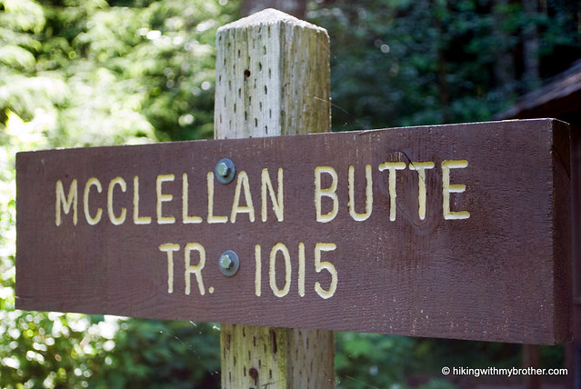
Nathan's Pick - McClellan Butte

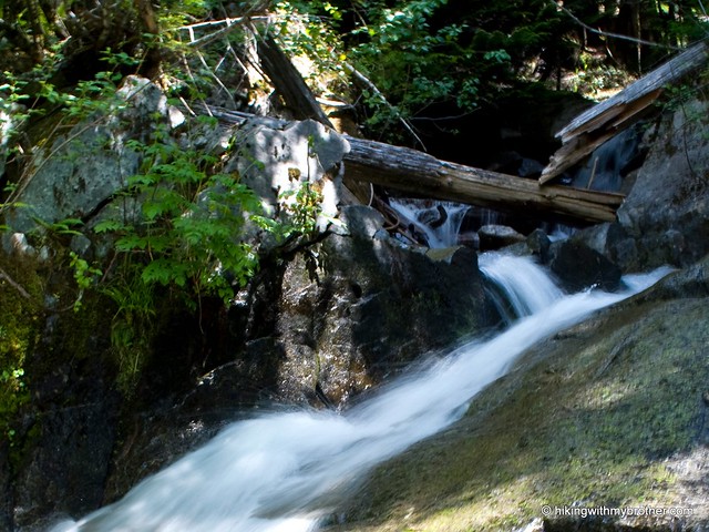
Sometimes what makes a hike memorable is not simply the dramatic views or the engaging geology, but is instead more wrapped up in the experience itself. For me, the exposed precipice of McClellan Butte had been an alluring goal for many, many months. Its rocky crown stood in stark contrast to every other hike we were planning in the foreseeable future, yet it remained denied to us as snows continued to cling to those heights each time we passed under McClellan on our way to another destination. So it was with immense satisfaction that we began the long trail to the top, following it as it wraps around every side of the mountain, with frequent opportunities to pause and take in the varied landscape. With the snows gone from the top, the final scramble did not pose much of a barrier to reaching the remaining heights.

Mt. Defiance is also a great hike, with a lot of things to see and do along the way. Understandably, there were a lot of folks that wanted to take a dip in Mason Lake, others on their way to Bandera, and others that just wanted to visit the Ira Spring Memorial. While beautiful, the trails to Defiance are also popular. McClellan, on the other hand, with few intermediate destinations along the route, had little in the way of company, while that final scramble tends to keep some the less experienced at bay. I’ll admit that Defiance probably has the better views, but if you’re looking for solitude as well as that satisfaction for pinpointing exactly where you were standing when looking up at a mountainside, go with McClellan.


Jer's PhotoJer's Pick - Mt. Defiance

The vibrant meadows and stadium views on the slopes of Defiance made my choice of favorite hike a simple one. As you traipse through forests, past an alpine lake, and into a kaleidoscope of wildflowers, it is hard to imagine a day hike that can offer more. Do not let stories of heat, dust, and steep terrain dissuade you from what is easily one of the most rewarding hikes near Seattle. As with any outdoor experience, timing and preparation are essential to getting the most out of your trip. Sunscreen, bug spray, and hiking poles are a must. Time your trip so you can be on top of the mountain early, to avoid the heat of the day on the open slopes of the mountain. After a climactic summit, hike back down to Mason Lake for lunch and a refreshing swim. Better yet, make a weekend out of it by camping at Mason Lake, which will give you ample time to summit Mt. Defiance and to explore the nearby lakes, Kulla Kulla, Island, and Little Mason.

It is hard to find flaws in a hike like McClellan Butte, but I do think the scramble, while not overly difficult, can greatly limit the enjoyment of this hike if left uncompleted. More than half of what is possible to see is only visible from the summit. If you are hiking alone or are not comfortable scrambling, do nearby Mt. Defiance instead and you will actually end up with superior views because Defiance rises 400ft above McClellan. If you only have time for one hike, make it Mt. Defiance.

Mt. St. Helens Crater - Photosynth

Jer's PhotoDespite the untold thousands of images of Mt. St. Helens out there, we were unprepared for the reality of being brought face-to-face with that broken landscape. Descriptions of those geologic forces that reduced much of the mountain to ruin and rubble often ring hallow; unable to evoke the kind of awe one feels when standing on the summit. Attempting to capture something of that feeling, we put together the largest photosynth we've tried so far - a full 180-degree view from the rim of the crater.


Are you new to photosynth? Check out the first photosynth blog post for more information.

Mt. Defiance & Mason Lake

Our Hiking Time: 6h
Total Ascent: 3400ft
Highest Point: 5584ft
Total Distance: 10.5 miles
Location: N 47° 26.1120, W 121° 33.8580
Required Permit: Northwest Forest Pass
Difficulty: Hard

Nathan's PhotoA sunny summer day with a forecast of clear skies has a way of shaking up the best laid plans, bending them toward mountaintops and lookouts. And so it was that we recently found ourselves once again at Ira Spring Memorial Trail #1038, this time readying ourselves for a trek up to the top of Mt. Defiance by way of Mason Lake.

mt defiance hikingwithmybrother
Since it was first blazed in 1958, the Mason Lake Trail #1038 has had a reputation for being steep and dirty. Over the years thousands of boots had badly eroded the trail, and hikers were forced to negotiate long uphill stretches over rocks and boulders. At the urging of wilderness advocate Ira Spring, a new route was proposed to address the trail damage, the steep grade, and the rocky obstacle course. Between 2003 and 2004, a small army of volunteers in coordination with Forest Service made the trail a reality. With the passing of Spring in 2003, the new trail was dedicated the Ira Spring Memorial Trail.

There's a lot more to Mt. Defiance and Mason Lake, and you can learn all about it in our book, Hiking Through History Washington.  You'll find a trail map, route descriptions, history, and more for this and many more hikes throughout the State. Help support hikingwithmybrother.com and the work we do by picking up a copy!

To get there, take I-90 to Exit 45, going left under the freeway to Forest Road 9030. Follow FR 9030 for about a mile until the road splits. Veer left onto FR 9031 and follow it for two more miles until the road terminates in a parking lot. - Nathan

Print Google Directions >>

Mt. Defiance - Mason Lake

McClellan Butte Trail #1015

Our Hiking Time: 5h 30m
Total Ascent: 3600ft
Highest Point: 5162ft
Total Distance: 10 miles
Location: N 47° 24.3900, W 121° 37.3200
Required Permit: Northwest Forest Pass
Difficulty: Moderate

Nathan's PhotoWe took a moment, while gearing up at the McClellan Butte trailhead, to think about the many months we had been waiting to ascend the snow-covered crags we’d spied on so many of our previous hikes. Each time we glimpsed the exposed rock that seemed to be bursting forth from the forested mountain reaffirmed our desire to claim the peak. So it was with much anticipation that we took our first steps on the trail.

mcclellan butte hikingwithmybrotherMcClellan Butte is the perfect alternative to Mt. Si if you’re looking for a good training hike without the crowds. In high summer and early fall, once all the snow has finally melted away, the hike should not pose too much difficulty for the whole family to reach the top. While a steady uphill climb, frequent openings in the treeline offer ideal places to catch your breath before pushing onward. While the views are similar to many of the other peaks in the area, the allure of the exposed crags with the minimum of mileage to get there makes this a great hike.

There's a lot more to McClellan Butte, and you can learn all about it in our book, Hiking Through History Washington.  You'll find a trail map, route descriptions, history, and more for this and many more hikes throughout the State. Help support hikingwithmybrother.com and the work we do by picking up a copy!

To get there, take I-90 out to Exit 42. At the stop sign turn right and follow Forest Road 55 for less than a half-mile to the McClellan Butte spur heading uphill on your right. Follow the spur to the trailhead parking lot. - Nathan

Print Google Directions >>

McClellan Butte
Copyright 2008-2016 - hikingwithmybrother.com
hikingwithmybrother@gmail.com