


Available Online!
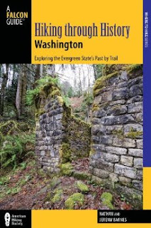
 Now that it’s February, our guidebook has made it out to the shelves of local bookstores around Washington. While many of our readers know the book is available, we wanted to highlight a few of the features of the book and explain how we hope the guidebook can best be used.
First we should clarify what you’re getting when you purchase the guidebook. You get 50 hikes (40 full hikes and 10 “Honorable Mentions” which do not have full maps, but are otherwise complete) that we have carefully chosen to include a variety in the degree of difficulty and type of destination, so we could make sure there is something for every hiker, no matter what they are looking for. We’ve included everything from challenging summertime summits to short winter walks. You’ll also find waterfalls, alpine lakes, very popular hikes and a handful of obscure ones. And you'll find historical background for every hike - although this is first and foremost a hiking guidebook, so expect the bulk of the focus to be on the hikes themselves.
All the hikes are within about 100 miles of Seattle, and are grouped roughly by the highway corridor they are located in. The guidebook sends readers out to the eastern side of the Olympic Peninsula along Highway 101 and out west along Interstate 90 toward Snoqualmie Pass. There are hikes down south along Highway 410 as it winds its way out toward Mt. Rainier National Park, and to the north there are quite a few hikes along Highway 2 and the Mountain Loop Highway. Please note that the majority of the hikes are in western Washington, despite the title of the guidebook. Our hope is that as we continue on this journey of writing about our hikes, future editions of this book will clarify this.
 Beyond getting all the information you need to enjoy the hikes in the book, we also worked with the publisher to make sure the layout of the book was helpful and easy to use. Each hike is broken into sections allowing you to quickly get to the information you want. You won’t need to fish through paragraphs of trail history to find the location of the trailhead or turn-by-turn hiking directions. Of course, if you’re like us and you want to know the story behind the trail, it’s easy to flip to the history section for a few paragraphs of history. If you prefer prose, you can read the hike overview for a description of the trail route, but we’ve also provided succinct directions and mileages so you don’t have to do any more reading than you’d like.
Most of the hikes include a large, full color map that is easy to read and includes most of the features we reference in the text. If you’re someone that prefers to use a map to navigate, we think you’ll be pleased with what we’ve put together. We’ve also included quite a bit of our photography to give you a glimpse of what you can expect to find on the trail. Our goal was to try and translate the visual feeling of the website into a guidebook. The result is a guide that is more visually engaging than most, with a lot of color and a lot of landscapes we think will help inspire you to hit the trail.
 We’ve written this guidebook with our website in mind. The idea is that the website will complement the guidebook – you’ll still be able to find the shortened versions of the hikes in the guidebook on our website along with any updated information about the hike. The idea is to try and make a “living” guidebook that will be continue to be useful as changes are made necessary by washouts, construction or trail re-routes. In addition, you can come to the website to download GPX routes for all the hikes featured in the guidebook, print out Google directions to the trailhead, and read any recent comments other hikers have posted about the hike. Plus, it’s always useful to come to hikingwithmybrother.com to check out our hiking map to see what is nearby your destination. Never hurts to check out other options!
Thanks again for all your support over the years. We hope you’ll pick up a copy of Hiking Through History Washington and help us continue this project into the future. We think we’ve put something together that you’ll find not only informative and easy to use, but also a guide you’ll enjoy using. We’ll see you on the trail. -Nathan
 Almost every weekend for years, we have been trekking down hiking trails across Washington and reporting our experience on


