


Total Ascent: 1500ft
Highest Point: 4700ft
Total Distance: 4.2 miles
Location: N 47° 42.263, W 121° 5.190
Required Permit: None
Difficulty: Moderate
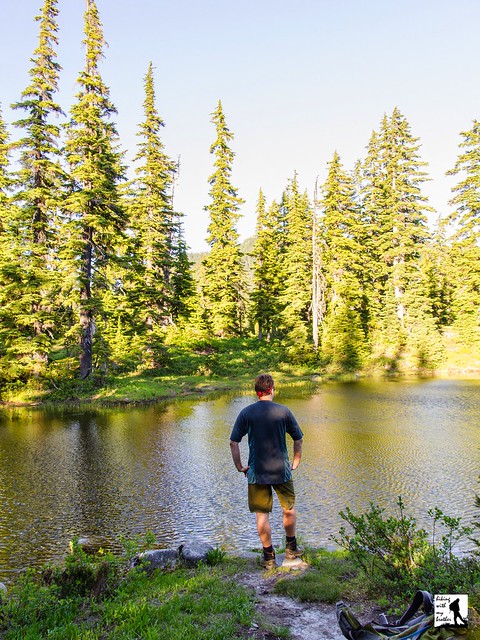
 Not long ago we took advantage of a sunny summer afternoon to return to Stevens Pass and visit the Alpine Lakes Wilderness. We had our sights set on Hope and Mig Lakes, a diminutive pair of tarns tucked into mountaintop meadows. With the promise of picturesque lakes and a refreshing dunk in an alpine lake, we started up the trail in the heat of the day.
Unless they're following the Pacific Crest Trail, most hikers access Hope and Mig Lakes via the Tunnel Creek Trail #1061. Tunnel Creek was named for the nearby Burlington Northern Tunnel that was drilled beneath Stevens Pass. The story of the tunnel and the railroad route over the pass it replaced can be found in our Iron Goat Trail report. As for Hope and Mig Lakes, we have yet to dig up any background on their story.
 The Tunnel Creek Trail #1061 begins by climbing up onto the shoulders of the mountainside into a mature forest of fir, hemlock and cedar. From the trailhead, the climbing never really stops until you reach Hope Lake, alternating between switchbacks and traversing ever upward. While some sections of trail have been improved, much of the route is rocky, narrow, and steep. As you press onward, talus fields offer occasional glimpses of the surrounding landscape and the valley below, while small streams cut across your path adding a little variety to your ascent. After about 1.5 miles cross into the Alpine Lakes Wilderness and not long after reach the shores of Hope Lake as the route joins the Pacific Crest Trail.
 From Hope Lake, head left along the PCT, quickly leaving dense forest behind. Here the trees thin and yield to expanding meadows. If you’re heading up in the late spring or early summer, expect to see this area brimming with wildflowers and buzzing with bees. Later in the season you’ll find plenty of huckleberries. After .5 miles find yourself at Mig Lake, quietly nestled at the base of a small prominence. The lake’s shores are lined with an alluring mixture of grassy meadows and clusters of evergreens. Find a comfortable spot to settle down and enjoy this quiet and idyllic scene. Looking for more? Continue onward to find Swimming Deer Lake in about a mile and beyond that Josephine Lake at 4.3 miles from the trailhead.

To get there, take US 2 out to milepost 60. Just beyond the milepost, as the highway begins to turn sharply to the left, you will cross over Tunnel Creek and find FR 6095 on your right. Take a right, following FR 6095 1.2 miles to an intersection. Veer left and find the marked trailhead within a few hundred feet. -Nathan
Print Google Directions >>
0 Comments:
Post a Comment