


Total Ascent: 600ft
Highest Point: 1400ft
Total Distance: 3 miles
Location: N 47° 31.2500, W 122° 5.4833
Required Permit: None
Difficulty: Easy

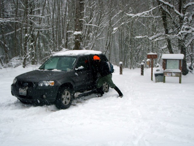
 Despite greater Seattle being pretty much snowed in, and I-90 closed past North Bend, and fresh snow beginning to fall, we decided to go for a quick hike anyway. Still, this severely limited our options. We chose Cougar Mountain because we were familiar with parts of it already and knew the 8 inches of snow would make the hike that much more fun. Plus it would round out the Cougar-Squak-Tiger trifecta for us. Major roads were not too bad and we managed to make it to the Anti-Aircraft Peak Trailhead with only a few questionable moments. We positioned the car so we wouldn’t get stuck, geared up, and took a study of the free trail maps before setting off.
 The peak is named in honor Cougar Mountain's military legacy. Following World War II, 90mm anti-aircraft guns were installed in 1953 to guard Puget Sound until they were replaced from 1957-1964 by a Nike Ajax Missile Defense System. The installation languished until 1983 when King County acquired it from the military and began developing a regional park to preserve Cougar Mountain's cultural and historic heritage. Envisioned by Harvey Manning and first proposed in 1979, the Cougar Mountain Regional Park concept eventually managed to block planned residential development in the park and gain enough voter support to pass a bond measure. Today the park is the largest “urban wildland” in the United States with over 3,000 acres of forest riddled with 36 miles of trails.

We took to the trail and tromped down the Tibbetts Marsh trail toward the Fantastic Erratic, a short mile and a half away. The trails are wide and very well used and maintained, taking you over streams, beside gullies, and through a mixed forest of alders and evergreens. The network of trails is sprawling but well signed. If you’re unfamiliar with the 45 trail names that appear on these signs, however, be sure to take a map to help reorient you when needed. Trails are also helpfully named with what side of the park they are on they are at as the first letter, (N)orth, (S)outh, (E)ast, (W)est and (C)enter.
The Fantastic Erratic was much less fantastic under a layer of snow, but the trek down to the basin where it resides was worth it - especially after Jer took a tumble or three off the trail and the Erratic itself. Not only did the snow keep most people away, but provided that close,
 insulated feel, making it seem like were snowshoeing deep in the Cascades instead of within a few miles of sprawling housing developments. We did not meet up with anyone else on the trail, though the fresh tracks we encountered let us know we were not entirely alone. Having started at the top, our way back was almost entirely uphill, made more slightly more difficult by the icy crust that had formed over the snow clawing at our boots and gaiters.
Overall, the trails are easy – great for the family, pets, or trail running – though from our own experience and from everything we’ve read, this is a very popular destination, so expect some company on your forays. The Anti-Aircraft Trailhead can be accessed via I-90 Exit 13. Take a left up Lakemont Boulevard following for roughly 3 miles before taking a left onto Cougar Mountain Way. Meander through the housing developments, continuing to head uphill and Cougar Mountain Way will change into Cougar Mountain Drive and terminate in the trail head parking lot. - Nathan
Print Google Directions >>
1 Comments:
This is one of my favorite posts! Awesome pics...great bit of history...wildlife! My favorite part is how you didn't get lost and slowly freeze to death after venturing out an hour before another wave of the worst snowstorm in 20 years was due to hit the area. Rock on, guys. Rock on.
Oh, and I dig the new map hard/medium/easy functionality. Nice work!
Post a Comment