about us | links | permit info
Subscribe to Hiking With My Brother Email Subscribe Follow Hiking With My Brother on Facebook Follow Hiking With My Brother on Twitter Hiking With My Brother Picasa Hiking With My Brother YouTube

Summit Lake Loop Trail #1177

Our Hiking Time: 2h 45m
Total Ascent: 1300ft
Highest Point: 5800ft
Total Distance: 6.1 miles
Location: N 47° 2.3333 W 121° 50.1539
Required Permit: Northwest Forest Pass
Difficulty: Moderate

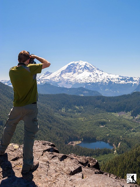
Nathan's PhotoAt the end of last summer we headed out toward the Carbon River entrance to Mt. Rainier National Park to do a little exploring in that area. One of the hikes we chose was Summit Lake, which is also one of the most popular. With big views of Mt. Rainier and a sizable alpine lake, it was easy to see why.

Summit Lake is a glacially carved alpine lake situated at the upper end of the Cayada Creek Valley just inside the Clearwater Wilderness. The Wilderness was established in 1984 and now protects over 14,000 acres of old growth forest and wildlife. Records are a bit sketchy, but it seems likely that the Summit Lake Trail was first blazed by the Forest Service when building the fire lookout that was once perched on nearby Bearhead Mountain. Summit Lake serves as a excellent water source in the summer months, and the lookouts stationed on Bearhead Mountain would have been drawn to the picturesque setting of the lakeshore. Today, visitors flock to the Summit Lake to take in that same alluring mixture of meadow, snowcapped mountain and alpine lake.

From the trailhead, the Summit Lake Trail #1177 begins by climbing up through a young forest still recovering from a recent harvest. Soon find yourself entering more mature stands of fir and hemlock as the trail swings into a long switchback up the mountainside. The trail here is fairly wide and well maintained, though there are plenty of roots to trip you up if you’re not paying attention. After about a mile of trail reach a junction with the Carbon River Trail #1179 and Twin Lake. A short unmarked trail leads out to lonely Twin Lake, which lacks both a twin and the impressive landscape waiting at Summit Lake.

Push on from the junction to one of the steeper sections of the hike, following the trial as it quickly ascends the ridgeline. The grade soon becomes more reasonable, giving you time to enjoy the wildflowers that often line the trail, as well as occasional pocket views of Lake Lily hiding on the other side of the ridge. Roughly 2.5 miles from the trailhead emerge from the woods into the grassy meadows surrounding Summit Lake. Ahead of you the rocky prominence of Summit Lake Peak rises directly behind the lake and as you reach the lakeshore, Mt. Rainier looms large to the south. Settle in to enjoy the lake or press onward for bigger views.

If you’re up for more, the trail splits into a loop, winding around the lake and up to the top of Summit Lake Peak. Either way you go, there is often wildlife found in the meadows, including bear, deer, marmot and elk. The trail to the top is more challenging than the trail to the lake; it’s rough, steep and narrow, but the rewards are worth the extra effort. From the top, the deep blue of Summit Lake competes with the white flanks of Mt. Rainier. The closest neighbors are Bearhead Mountain to the west and Pitcher Mountain to the east, with Coplay Lake filling a bowl just to the right of Bearhead. Beyond that, an ocean of mountaintops spreads out in every direction, with far too many peaks to name. When you’ve had your fill, continue down the trail and complete the loop.

This is a fairly popular trail in the summer months, and it's easy to see why. The wildflower-filled meadows around Summit Lake are sure to please any fan of an alpine lake, and the big views from the top of Summit Lake Peak are more than enough to satisfy a devoted peakbagger. While it does have some elevation, most hikers will find this trail fairly accessible. And, with campsites available around the lake and more to explore along the Carbon River Trail #1179 and the Bearhead Mountain Trail #1179.1, this hike also makes for a decent backpacking destination.

To get there, take I-5 South to I-405. From I-405 take SR 167 south toward Auburn. In 20 miles take the SR 410 Exit toward Sumner/Yakima. Follow SR 410 for 12 miles to SR 165. Take a right and continue on SR 165 for about 10 miles through Wilkeson and Carbonado to the Carbon River Road/Mowich Lake Road junction. Veer left onto the Carbon River Road and follow for 7.5 miles to FR 7810, just before the Carbon River Ranger Station. Turn left onto the FR 7810 and continue 6.5 unpaved miles to the trailhead at the end of the road. –Nathan


Print Google Directions >>

Summit Lake

Falls View Canyon Trail #868

Our Hiking Time: 1h 10m
Total Ascent: 300ft
Highest Point: 400ft
Total Distance: 1.8 miles
Location: N 47° 47.3633, W 122° 55.7516
Required Permit: None
Difficulty: Easy

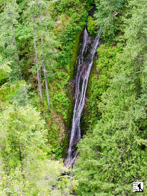
Nathan's PhotoThe Olympic Peninsula offers everything from sandy beaches to windswept peaks and there are all manner of hiking trails to access those destinations. Some of those trails are difficult to reach, while others can be found just off the highway. This hike is in the latter category. The trails at Falls View offer a rhododendron-lined tour of a river canyon and a front row seat to a waterfall tumbling down 200ft into the Big Quilcene River. As an added bonus, these short and easily accessible trails can be explored any time of year.

Falls View Campground is situated on a bluff above the Big Quilcene River and likely owes its existence to its namesake waterfall. We weren’t able to dig up much in the way of the history behind the building of this campground, although we did find that the area is sometimes referred to as Fallsview in older guides and reference books. For the record, US Board of Geographic Names lists the official name of the campground as “Falls View.” While the falls themselves have been christened Falls View Falls or sometimes Campground Falls, the stream that creates the cascade has gone unnamed.

This hike is actually two separate trails, the Falls View Loop Trail #848 and the Falls View Canyon Trail #868. Both trails begin from the campground. The Falls View Loop trail clocks in at about a tenth of a mile, and leads out to a viewpoint overlooking Falls View Falls before looping back to the parking area. Take a few minutes to wander down this trail to get an idea of the canyon you will soon be descending into. Once you return to the trailhead, head toward the Falls View Canyon Trail, which quickly switchbacks down to the riverside to a view of the base of the falls.

From the canyon floor the trail wanders through a young forest of fir and alder rising out of a thick underlayer of fern and salal. The roar of the river is never far as you progress along the narrow trail, which splits after about three-quarters of a mile.  Head right and continue onward to the far reaches of the trail to find a calm section of the Big Quilcene River.  Here the water pools at the end of a series of rapids, and the shore provides plenty of room to stretch out and enjoy the river. Once you’re done exploring the rocks, return to the trail and follow it as it loops back toward the campground. This section of trail  is a little further away from the river, and it passes quickly. Before you know it you’ll reconnect with the trail and the river and find yourself climbing up the canyon wall to the trailhead.

While this pleasant river walk isn’t the most spectacular trail in the Olympic National Park, it does manage to pack both panoramic views of a big waterfall and access to a rushing river filled with moss-covered boulders into less than 2 miles of trail. This makes it a great addition to a day of short hikes or a nice way to stretch your legs while traveling on to your final destination. There is a bit of a climb into and out of the canyon, but hikers of all ages should be able to tackle these trails without a lot of difficulty. Falls View Falls is somewhat seasonal, and is best viewed in the winter and spring when waters are at their highest. In warmer years, the falls can dry up completely. If you’re going in the winter, the campground may be closed - simply park outside the gates and hike the short distance to the trailhead.

To get there, take I-5 south through Tacoma to Exit 132B SR 16 toward Bremerton. Continue on SR 16 for 27 miles to merge with SR 3 North. Follow SR 3 to the Hood Canal Bridge, taking a left over the bridge onto State Route 104. Follow SR 104 as it merges onto US 101 and continue 13.4 miles to Falls View Campground. Turn right and find the trailhead in the day use area of the campground. -Nathan

Print Google Directions >>

Falls View Falls

Duckabush River Trail #803

Our Hiking Time: 3h 45m
Total Ascent: 1700ft (1500ft in; 200ft out)
Highest Point: 1600ft
Total Distance: 7.0 miles
Location: N 47° 41.028, W 123° 5.040
Required Permit: Northwest Forest Pass
Difficulty: Moderate

Nathan's Photo
Last year we spent some time on the Olympic Peninsula and had the chance to explore a number of trails in the Duckabush River Valley. One of the most enjoyable was the Duckabush River Trail, which offers easy access to a variety of landscapes within The Brothers Wilderness. Not only is there a lot to see along this trail, but its relatively low elevation means you can explore this trail year-round.

The bounty of the Duckabush River Valley has attracted people for hundreds if not thousands of years. The Duckabush was named by the Twana people, who called it dohiaboos, which translates to “a reddish face” in reference to the red cliffs in the area. The Twana also maintained a winter village at the mouth of the Duckabush, known as duxwyabu', or “place of the crooked-jaw salmon.” That village served as a winter shelter, but throughout the rest of the year, the Twana would forage deep into the river valley, following trails worn into the valley floor over generations. Despite an influx of European settlers and treaty boundaries that relocated many traditional villages, a Twana community lingered here at least until 1880. Beginning at the turn of the 20th century, loggers began to moved into the area. The Webb Logging Company claimed the Duckabush River Valley in 1912, and began building a logging railroad on the bones of native trails. The rugged terrain proved difficult, and rough-shod logging practices sparked forest fires in 1925 and 1929. Together with a growing push toward conservation in the region, the 1929 fire brought an end to logging along the Duckabush.

Even before the logging ceased, hiking trails were beginning to be built along the Duckabush. The Duckabush River Trail reached Cliff Creek by 1918, and was extended by Civilian Conservation Corps workers based out of the Interrorem Guard Station. Over the years the valley continued to see fires, most recently with the lightning-sparked Ten-Mile Fire in 2009 and the Big Hump Fire of 2011. The Big Hump Fire was started on August 31, 2011 by an abandoned campfire, and eventually burned more than 1,000 acres of forest, closing the Duckabush Trail for months. Today, the charred trees lining the trail and the lingering smell of ash serve as reminders of the event.

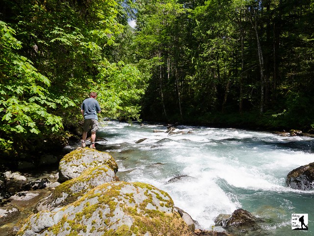
The Duckabush River Trail #803 begins by following a reclaimed logging road into a young forest rising out of a sea of moss and fern. As you wander deeper into the woods, the trail begins its gentle ascent of Little Hump and enters The Brothers Wilderness around the 1 mile mark. From the top of Little Hump, you get your first glimpses of the river valley before descending down toward the river. Soon, the trail flattens and connects with the old Webb Logging Company railbed, eventually delivering you to the riverside. The sounds of the river are your hiking companion for the next half-mile, as you pass a number of idyllic spots to stop and linger by the riverside. After about 2.5 miles, reach the base of Big Hump and the end of easy hiking. Many hikers choose to call it a day here, as the river makes for a decent destination and turning around at this point avoids Big Hump’s elevation and rough trail.

For those looking for bigger views and more trail, begin switchbacking up the rocky trail carved into the shoulders of Big Hump. Occasionally rough and narrow, the route plows up the moutainside, gaining 1,000 feet in a little over a mile. As you climb, you'll pass trees bearing scars of the Big Hump Fire, eventually reaching large stands of blackened timber. Near the summit, a rocky overlook provides the best views of the river valley and St. Peter’s Dome. There’s plenty of room here to settle in and enjoy the landscape.

Still want more? The trail continues to the top of Big Hump, but there aren’t any views from the forested summit. The trail then descends back down to the river and into old growth forest, eventually reaching Five Mile Camp. At 6.7 miles the trail enters the Olympic National Park and from there continues another 16 miles out to O’Neil Pass.

This trail provides decent year-round hiking, through sections of trail on Big Hump can be dangerous in the winter. The route also travels through a variety of landscapes, from the lush and mossy riverside to the dry and dusty cliffs of Big Hump. While hikers of all ages should be able to tackle the hike out to the roaring Duckabush River, those looking for a more serious outing will find an ascent of Big Hump enough of a challenge to satisfy. With spring right around the corner, add this one to your list of hikes to catch this year’s batch of wildflowers and blooming rhododendrons.

To get there, take I-5 south through Tacoma to Exit 132B SR 16 toward Bremerton. Continue on SR 16 for 27 miles to merge with SR 3 North. Follow SR 3 to the Hood Canal Bridge, taking a left over the bridge onto State Route 104. Follow SR 104 as it merges onto US 101 and continue 25 miles through Quilcene to Duckabush Road (FR 2150). Turn right and follow the road 6 miles to FR 2510-060. to the trailhead (pavement ends after 3.7 miles at the Interrorem Guard Station). Turn right and find the trailhead in a few hundred feet. -Nathan

Print Google Directions >>

Duckabush River
Copyright 2008-2016 - hikingwithmybrother.com
hikingwithmybrother@gmail.com