about us | links | permit info
Subscribe to Hiking With My Brother Email Subscribe Follow Hiking With My Brother on Facebook Follow Hiking With My Brother on Twitter Hiking With My Brother Picasa Hiking With My Brother YouTube

North Lake via Independence Lake Trail #712

Our Hiking Time: 4h 10m
Total Ascent: 2100ft (1300ft in; 800ft out)
Highest Point: 4900ft
Total Distance: 6.0 miles
Location: N 48° 8.0280, W 121° 31.2540
Required Permit: Northwest Forest Pass
Difficulty: Hard

Nathan's Photo
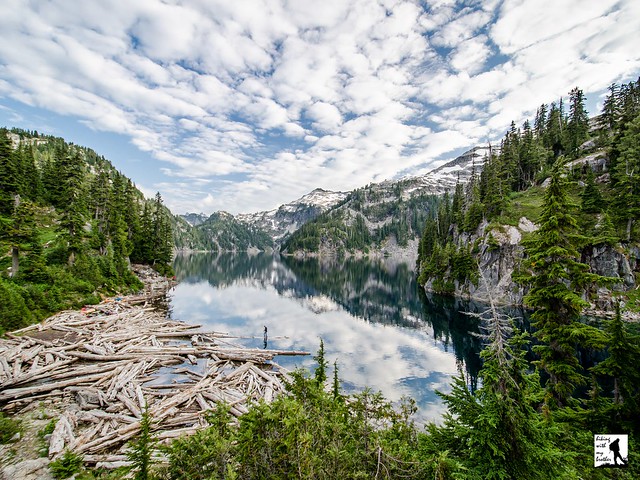
A few weeks ago we headed out along the Mountain Loop Highway in search of alpine lakes and a bit of solitude. We found exactly what we were looking for near Big Four Mountain and the area around Coal Creek. Here you’ll find Independence Lake and North Lake waiting quietly for hikers to discover them.

Like most of the areas surrounding the Mountain Loop Highway, the Coal Creek Basin has seen its fair share of mining and logging activity. Pulling ore and lumber down from the mountains led to fledgling communities popped up along the wagon road turned railway we now know as the Mountain Loop Highway. One such community is nearby Silverton, that started out as a mining camp back in the 1880s. Back then it was known as “Independence” and was little more than a gathering place along the Stilliguamish River for miners and their supplies. As folks settled in and began to build a more permanent presence, moves were made to incorporate the settlement into a town. In 1891 the name was changed to “Silverton” in reference to silver ore that had been found nearby. By 1905 Silverton was booming, with nearly a dozen mining companies pulling copper and silver out of nearby mines and the town boasted hotels, a newspaper and even a school. But as quickly as it grew, it was largely abandoned when the ore began to run low and mining operations moved on. By the the 1950s Silverton was a ghost town. Today, few people live year-round in the refurbished cabins that line the highway.

Still, the legacy of Silverton lingers. Independence Lake sits at the base of its namesake mountain, Independence Peak. Very likely both the lake and the mountain were named after the Independence camp that became Silverton. North Lake has a less interesting story - it was named for the North Fork of Falls Creek that drains it.

From the trailhead, the Independence Lake Trail #712 begins through young forest that quickly transitions into older growth. The trail wanders gently through hemlock and cedar, delivering you to the tree-lined shores of Independence Lake in less than three-quarters of a mile. Find plenty of logs and rocks to clamber on to get a better view of the lake. Follow the trail has rises along the shoulders of the hillsides above the lakeshore before dropping to the somewhat marshy end of the lake. Find a few campsites here as well as a backcountry toilet. Spend a few minutes enjoying the lake before continuing up to North Lake.

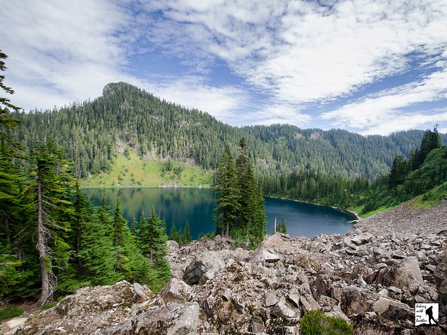
From Independence Lake, it can be a little confusing to find the North Lake Trail #712.1. There are a number of unmarked paths and the trail sign is all but obscured by the tree that is slowly growing around it. From the campsites follow the trail as it continues around the lake and then turns sharply uphill. From here you will switchback up the rocky slopes of Independence Peak toward your destination. The route is steep, narrow and a little rough. After about a mile, emerge from the treeline onto an open ridge overlooking a panorama of peaks and North Lake hundreds of feet below.

Whether you decide to make the descent or not, take some time to do a little exploring along the ridgeline. Clamber up the flanks of Independence Peak or follow the faint trail as it wanders to the west. Depending on your vantage point, there are quite a few mountaintops to see. To the west pick out Devils Thumb and Three Fingers in the distance. Whitehorse Mountain is just to the north of Three Fingers. To the north pick out Jumbo Mountain. Continue to follow the trail out to the end of the ridge for views to the east, including Mt. Pugh and Glacier Peak. If you're looking for a bit more of a workout, continue down to the lake shore. The path down to the lake is steep and almost primitive. Expect to use some trees as handholds as you pick your way down through boulder fields and grassy ledges cupping seasonal pools. The trail ends at the lake but the adventurous will not find the rocky shore too difficult to explore.

This is a great summer hike for those looking for an alternative to Lake Twentytwo or Heather Lake. Because the trail starts at a fairly high elevation, the trail delivers alpine lakes and decent views without much in the way of mileage. However, the high elevation means that the snows come early and linger until June or July. Still, once the trails are clear this hike has options for every hiker: the route to Independence Lake works well for the littlest hikers or anyone looking for a quick and easy walk in the woods, and those looking for more of a challenge can push on to North Lake and beyond.

To get there, take I-5 North to Exit 194. Follow Highway 2 for about two miles. Stay in the left lane and merge onto Lake Stevens Highway 204. Follow for two miles to Highway 9. Take the left onto Highway 9 toward Lake Stevens. In just under two miles, you’ll reach Highway 92 to Granite Falls. Take a right and follow for about nine miles to the Mountain Loop Highway. Take the MLH for 25.5 miles, just past the Big Four Picnic Area to Forest Road 4060 (signed Coal Lake Road). Take a left onto FR 4060 and follow the road, veering right when the road splits at .8 miles. Find the trailhead at the end of the road, 4.7 miles from the highway. -Nathan

Print Google Directions >>
North Lake

Steam Donkey Trail - Dosewallips State Park

Our Hiking Time: 1h 15m
Total Ascent: 450ft
Highest Point: 500ft
Total Distance: 3.0 miles
Location: N 47° 41.3820, W 122° 54.1860
Required Permit: Discover Pass
Difficulty: Easy

Nathan's Photo
A few months ago we spent a weekend exploring a number of hikes along the eastern shores of the Olympic Peninsula. We managed to fit in a wide variety of destinations that included everything from mountaintops to leisurely forest walks. Among those forest walks was the Steam Donkey Loop Trail, quietly tucked into the woods surrounding Dosewallips State Park.

Before Europeans made it to the Puget Sound, Native American tribes lived and traded along Hood Canal and the rivers that flow into it, including the Dosewallips River. The name is derived from the Twana word “dos-wail-opsh,” in reference to a legendary chief who was transformed by The Great Changer into a mountain near the head of the river.

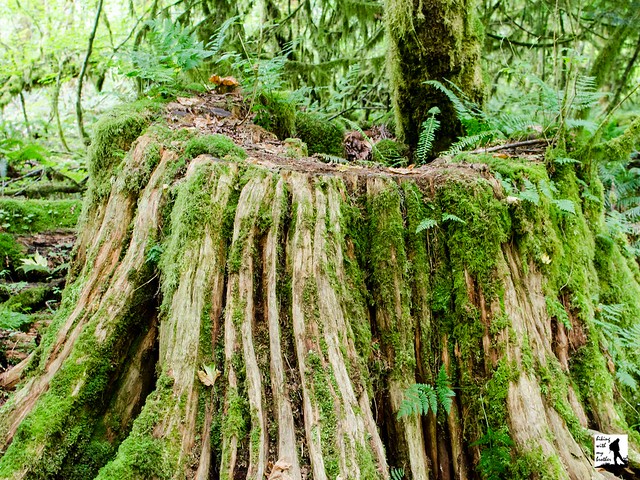
Back around the turn of the last century, the nearby town of Brinnon was quickly becoming a bustling logging community. In 1903, James Izett purchased his first timber claim in the Dosewallips River Valley, and quickly began construction of the first logging railroad south of the Dosewallips. The Izett Logging Company eventually built five miles of railroad to help haul timber down to Hood Canal where logs would be lashed together and floated down to lumber mills in booms. During this era, loggers used large steam engines - often called steam donkeys - to help pull logs and machinery up and down mountainsides. In 1910 wildfires ravaged one of the Izett logging camps, destroying two steam donkeys and a great deal of timber. Just three years later, James Izett passed away and the company was quickly sold off. The railroad was eventually removed, and today the railroad grade is still in use as part of the Dosewallips State Park trail network.

The hike begins at the Dosewallips State Park entrance booth. If you’re not camping in the park, ask the ranger where you can park to hike the trail. Usually there will be open spots right behind the booth. Once parked, follow a rough path near the booth to the Maple Valley Trailhead.  Here the actual trail begins and the path quickly enters a mixed second generation forest and soon dampens any nearby sounds from the campground. Almost immediately the Dosewallips River appears through breaks in the treeline as you glide through stands moss-heavy alders, maples and cedars. Continue following the river to a junction with the Rhody Cut-off, a shortcut that skips most of the hike and connects to the far side of the Steam Donkey Loop. Keep to the right and soon find yourself at the first of many bridges over Phantom Creek.

From Phantom Creek climb up through fields of sword fern and vine maple toward the park boundary. The trail levels out and passes by a partially cleared area that was logged a few years ago before turning sharply to the left and shortly arriving at a fire road. Cross it to connect with the Steam Donkey Loop Trail.  From here, the trail climbs slightly through the quiet forest, crossing the Phantom Creek twice before veering to the left and descending back toward the campground. On your descent pass the junction with the Izett Railroad Grade and later a junction signed "Railroad Grade Circa 1901" take a moment here to find the nearby  historical marker and look for rusted pieces of the area’s railroad history. Continue following the trail back down to the campground. The trail drops you back on the main park road. Head left back to the park entry booth.

If you’re not camping at Dosewallips State Park, this trail is better as an addition to a day of hiking in the area rather than the only hike you do. However, it works well in the winter when other hikes are less accessible and is ideal for younger hikers, as side trails and shortcuts provide ample opportunities to shorten the hike if needed. Although the park is quite popular, the trails get less traffic than expected, lending a feeling of the trail being more wild than it is. With 425 acres to explore, Dosewallips State Park is well worth a visit. Next time you’re in the area, give this “hidden” hike a try.

To get there, take I-5 south through Tacoma to Exit 132B SR 16 toward Bremerton. Continue on SR 16 for 27 miles to merge with SR 3 North. Follow SR 3 to the Hood Canal Bridge, taking a left over the bridge onto State Route 104. Follow SR 104 as it merges onto US 101 and continue 22 miles through Quilcene to Dosewallips State Park. -Nathan

Print Google Directions >>
Steam Donkey

Big Heart Lake via West Fork Foss Lakes Trail #1064

Our Hiking Time: 8h 30m
Total Ascent: 3600ft (3300ft in; 300ft out)
Highest Point: 4900ft
Total Distance: 14.0 miles
Location: N 47° 35.0760, W 19.1700
Required Permit: Northwest Forest Pass
Difficulty: Hard

Nathan's Photo
Not long ago we had the chance to spend a few days hiking through the Alpine Lakes Wilderness, enjoying the last of the summer sun. Looking to squeeze in a lot of sights on our adventure we headed toward the West Fork Foss Lakes Trail, to visit a collection of pristine alpine lakes. With the weather on our side it was easy to see why folks have been drawn to this area for decades.

Back around the turn of the last century, prospectors were exploring the Foss River Valley in search of mineral wealth. By 1906 the Foss River Consolidated Mining Company was formed out of various mining claims that had sprung up in the area. Copper Lake and Malachite Lake are part of the legacy of that era, as both were named for the presence of malachite copper ore found in the area. Today’s trail likely follows routes first cut by those early prospectors, and traces of abandoned boothpaths that once connected mining claims can still be found throughout the river valley. In 2006, flooding caused considerable damage to the West Fork Foss Lakes Trail, washing out bridges and transforming portions of the trail to rocky streambed. In 2010 the Washington Trails Association and the Ira Spring Trust worked to repair and re-route the first half-mile of trail.

From the trailhead, the West Fork Foss Lakes Trail #1064 enters a mixed forest of alder, hemlock and underbrush before crossing into the Alpine Lakes Wilderness. As you begin your climb note the dry streambed that parallels the trail, a legacy of the 2006 floods. At roughly a half-mile cross a sturdy bridge spanning a small canyon carved by those same floods. Continue climbing through deepening forest for another mile to Trout Lake. Tucked beneath the rocky slopes and exposed cliff-faces of Malachite Peak and Silver Eagle Peak, Trout Lake offers a taste of what is to come. With numerous campsites and plenty of room to fish, the lake is also a good option for backpacking with youngsters.

From Trout Lake the trail becomes steeper and rockier, switchbacking up the mountainside while following the outlet stream many folks call Copper Creek. The sheer cliffs and steep drop-offs in the area create a number of waterfalls often collectively referred to as the Waterfalls of the West Fork River Valley. Here water tumbles hundreds of feet down to the West Fork Foss River, much of which can be seen from the trail. Continue pushing up past the junction to Malachite Lake, over a bridge crossing the top of a waterfall and then across a series of stepping stones to eventually arrive at Copper Lake at just under the 4 mile mark. There is less camping at Copper Lake, though there are a few sites to be found. Copper Lake is a great destination for a day hike and the perfect place to settle down for a hard-earned break.

Continue onward along the shore of Copper Lake, through rockslides and past occasional viewpoints to the far end of the lake. Here the trail turns upward again, though the grade is more reasonable. After another mile and few hundred feet of elevation, arrive at Little Heart Lake nestled at the bottom of a rocky cirque. There is some camping here, but the real prize is another mile and a half up the trail.

The trail from Little Heart Lake to Big Heart Lake is the most challenging portion of the route. Not only does it come late in the hike, but much of the steep ascent is along exposed rocky slopes that offer big views, but little protection from the sun. The trail passes through talus fields and passes by any number of small tarns as it relentlessly pushes upward. After a little over a mile of climbing, the trail crosses over the ridge and begins quickly switchbacking down toward the lakeshore. Suddenly the trees pull away and Big Heart Lake lies sparkling before you, its shores a tangle of grey rock, bleached driftwood, vibrant evergreens and snowy ridgelines. Settle in to enjoy the view. If you’re camping, continue on the trail as it drops down to the water and crosses over a wide expanse of driftwood. From here, the trail begins to climb up a small hill. Start looking for a campsite as there are quite a few spots tucked into the hillside.

This stunning set of alpine lakes is more than worth the effort to reach them. Stacked nearly on top of one another, this trail packs a dozen big lakes into a fairly small area. The length and difficulty of this trail means that crowds tend to thin as you push closer to Big Heart Lake, making it a great backpacking destination. Still, the area is quite popular so do not expect to have the lake to yourself. However, if you’re up for a little exploring, Angeline Lake, Azurite Lake, and Chetwoot Lake can all be found beyond Big Heart Lake by following bootpaths or just doing a little bushwhacking. If you’re looking for solitude, we recommend looking there.

To get there, take Highway 2 out past Skykomish just beyond milepost 50. Take a right onto FR 68, also known as the Foss River Road. Continue on the road for 4.7 miles (the road becomes gravel after about a mile) to a junction with FR 6840. Veer left and follow FR 6840 for just under two miles to the end of the road and the West Fork trailhead. -Nathan

Print Google Directions >>

Big Heart Lake
Copyright 2008-2016 - hikingwithmybrother.com
hikingwithmybrother@gmail.com