about us | links | permit info
Subscribe to Hiking With My Brother Email Subscribe Follow Hiking With My Brother on Facebook Follow Hiking With My Brother on Twitter Hiking With My Brother Picasa Hiking With My Brother YouTube

Tonga Ridge Trail #1058 to Mount Sawyer

Our Hiking Time: 3h 30m
Total Ascent: 1200ft
Highest Point: 5480ft
Total Distance: 5.5 miles
Location: N 47° 40.0080, W 121° 13.4700
Required Permit: Northwest Forest Pass
Difficulty: Moderate

Nathan's Photo
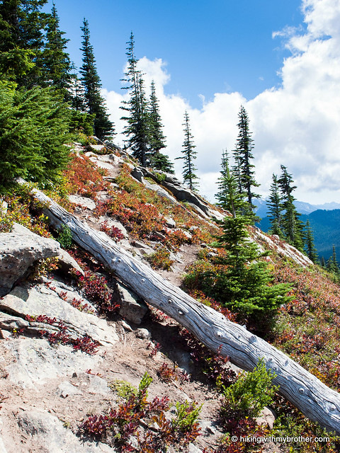
We recently had a chance check out Tonga Ridge, one of the most popular ridge hikes along Highway 2. With long views and a gentle grade, it’s easy to see why Tonga Ridge attracts so many hikers, and now that we near the end of summer, the trail is likely to see more traffic than usual as huckleberry pickers flock to the slopes of Mt. Sawyer to harvest this year’s crop.

This is a great all-season trail that we recommend every hiker. Whether you’re looking for a snowshoe, springtime wildflowers, summer berry picking or autumn colors, Tonga Ridge delivers. The trail is also fairly easy and should be approachable for hikers of all ages and experience, which tends to draw in the crowds. You can expect to share the trail with a lot of other folks on this popular hike, and the limited parking at the trailhead can be challenge on a crowded day. If at all possible, try to hit Tonga Ridge on a weekday when traffic will be lighter.

There's a lot more to Tonga Ridge, and you can learn all about it in our book, Hiking Through History Washington.  You'll find a trail map, route descriptions, history, and more for this and many more hikes throughout the State. Help support hikingwithmybrother.com and the work we do by picking up a copy!
To get there, take Highway 2 out past Skykomish just beyond milepost 50. Take a right onto FR 68, also known as the Foss River Road. Continue for about three-and-a-half miles to a junction, taking a left onto FR 6830 and following it for almost seven miles to the signed 310 spur. Head right onto the spur and drive a little over a mile to the end of the road and the trailhead. -Nathan

Print Google Directions >>
Tonga Ridge

Vesper Peak via Sunrise Mine Trail #707

Our Hiking Time: 6h 45m
Total Ascent: 3900ft
Highest Point: 6214ft
Total Distance: 6.6 miles
Location: N 48° 0.7800, W 121° 31.0740
Required Permit: Northwest Forest Pass
Difficulty: Hard

Nathan's Photo
This week we headed out to the Mountain Loop Highway to take on Vesper Peak, one of the many hikes in the area that remain snowbound most of the year. The hike description hinted at stunning views, a lake, and perhaps traces of a mining operation, but cautioned that the route was difficult and a little treacherous. Vesper Peak delivered on both counts – we got our views, but our legs paid for them.

This hike is not for everyone. It is difficult, scaling over 4000ft in a little over three miles on rough trail. Some route finding skills are occasionally required, depending on how snow covered the trail is, and above Vesper Creek you can expect to encounter snow all year. With those caveats, we recommend this hike for strong hikers looking for a challenge. And, because it is difficult, there is a bit less traffic on the trail, so you can expect to enjoy the views in relative solace.

There's a lot more to Vesper Peak, and you can learn all about it in our book, Hiking Through History Washington.  You'll find a trail map, route descriptions, history, and more for this and many more hikes throughout the State. Help support hikingwithmybrother.com and the work we do by picking up a copy!

To get there, take I-5 North to Exit 194. Follow Highway 2 for about two miles. Stay in the left lane and merge onto Lake Stevens Highway 204. Follow for two miles to Highway 9. Take the left onto Highway 9 toward Lake Stevens. In just under two miles, you’ll reach Highway 92 to Granite Falls. Take a right and follow for about nine miles to the Mountain Loop Highway. Take the MLH for almost 29 miles to the Sunrise Mine Road No. 4065 on your right. Follow the gravel road just under two-and-a-half miles to the end of the road and trailhead. –Nathan

Print Google Directions >>

Vesper Peak

Kachess Ridge Beacon Trail #1315

Our Hiking Time: 3h 45m
Total Ascent: 2200ft
Highest Point: 4600ft
Total Distance: 4.7 miles
Location: N 47° 16.9380, W 121° 10.6500
Required Permit: None.
Difficulty: Hard

Nathan's Photo
Sometimes it seems that the more hiking we do, the more trails we discover. For all the trail miles we’ve put into the I-90 corridor, there are always more trails on our list to hike. Recently we had the chance explore Kachess Ridge, a somewhat lesser-known trail that scales one of the many ridges surrounding Lake Kachess.


kachess ridge beacon hikingwithmybrotherKachess Ridge has a great deal to offer – it is easily accessible from the freeway, but surprisingly few hikers are to be found along the trail. And, because it is east of the Pass, it is an ideal early season hike. A word of caution however; the spring route up the ridge is steep and challenging, so we don’t recommend it for the inexperienced. Either approach makes for a hard hike, but we think the views are worth the extra effort.

There's a lot more to Kachess Ridge Beacon, and you can learn all about it in our book, Hiking Through History Washington.  You'll find a trail map, route descriptions, history, and more for this and many more hikes throughout the State. Help support hikingwithmybrother.com and the work we do by picking up a copy!


To get there, take I-90 to Exit 70. Take a left over the freeway and turn left onto West Sparks Road. Continue for a half-mile to FR 4818 (signed Kachess Dam Road) and take a right. Follow FR 4818 for a mile to an unmarked road on the right. Follow this road for a half-mile to the small parking area at the trailhead. -Nathan

Kachess Ridge Beacon
Copyright 2008-2016 - hikingwithmybrother.com
hikingwithmybrother@gmail.com