


Total Ascent: 3300ft
Highest Point: 5100ft
Total Distance: 17.2 miles
Location: N 46° 57.0419, W 121° 52.0980
Required Permit: National Park Pass
Difficulty: Hard
 This past summer we had the chance to explore a number of trails in the Carbon River area, including portions of the Wonderland Trail. Our Wonderland travels included the Isput Pass Trail, a long trek following Isput Creek up to a secluded mountain pass. Easily one of the more challenging hikes in the area, the upper portions of the route have ample views to distract you on the way up.
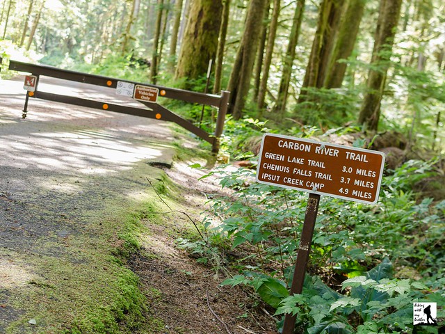
 The hike begins from the Carbon River Entrance, following the Carbon River Road through a temperate rain forest of fir and cedar. The road provides access to a number of hikes, and many people opt to bike the road to cut down on travel time, though there is something to be said for the more leisurely walk through the woods. Flat and wide, the miles pass quickly and easily, passing the Green Lake Trailhead after about three miles and the Chenuis Falls Trailhead another half-mile or so beyond. The river is your constant companion as you push past these popular day hikes toward Ipsut Campground. The campground is a good place to stop for a breather or to set up camp if you’re planning on a longer trip.
From the campground, the road quickly transitions to trail, and the lush forest closes in. The trail remains almost flat as you cross over a number of creeks and streams each with varying water levels. Stroll for a half-mile to a spur leading out to Ipsut Falls. As the name suggests, the falls are a little hard to see, but it’s worth a few extra minutes to catch a glimpse of the roaring cascade tucked into this rocky gorge. Once you’ve taken a look, head up the trail to the junction a few hundred feet to connect with the Wonderland Trail. Veer right and uphill toward Ipsut Pass and Mowich Lake.
Now the work begins. Everything between the junction and the top of the pass is up, up, up. Some portions are steeper than others, but expect the next 3.3 miles to be an uphill battle. Initially you are confined to the forest, but as you climb the trees give way to open expanses of greenery and underbrush, allowing increasingly better views of the valley below. As you near the top the trail begins to steepen and switchback steadily upwards. The rocky trail runs along exposed cliffs before depositing you at the forested pass. Venturing a few hundred feet over the pass will connect you to the Mowich Lake Trail. Find a welcoming spot to enjoy the view and a hard-earned snack before heading back down.

To get there, take I-5 South to I-405. From I-405 take SR 167 south toward Auburn. In 20 miles take the SR 410 Exit toward Sumner/Yakima. Follow SR 410 for 12 miles to SR 165. Take a right and continue on SR 165 for about 10 miles through Wilkeson and Carbonado to the Carbon River Road/Mowich Lake Road junction. Veer left onto the Carbon River Road and follow for 7.7 miles to the Carbon River Entrance of Mt. Rainer and parking. -Nathan
Print Google Directions >>
0 Comments:
Post a Comment