


Total Ascent: 3600ft (3300ft in; 300ft out)
Highest Point: 4900ft
Total Distance: 14.0 miles
Location: N 47° 35.0760, W 19.1700
Required Permit: Northwest Forest Pass
Difficulty: Hard
 Not long ago we had the chance to spend a few days hiking through the Alpine Lakes Wilderness, enjoying the last of the summer sun. Looking to squeeze in a lot of sights on our adventure we headed toward the West Fork Foss Lakes Trail, to visit a collection of pristine alpine lakes. With the weather on our side it was easy to see why folks have been drawn to this area for decades.
Back around the turn of the last century, prospectors were exploring the Foss River Valley in search of mineral wealth. By 1906 the Foss River Consolidated Mining Company was formed out of various mining claims that had sprung up in the area. Copper Lake and Malachite Lake are part of the legacy of that era, as both were named for the presence of malachite copper ore found in the area. Today’s trail likely follows routes first cut by those early prospectors, and traces of abandoned boothpaths that once connected mining claims can still be found throughout the river valley. In 2006, flooding caused considerable damage to the West Fork Foss Lakes Trail, washing out bridges and transforming portions of the trail to rocky streambed. In 2010 the Washington Trails Association and the Ira Spring Trust worked to repair and re-route the first half-mile of trail.
 From the trailhead, the West Fork Foss Lakes Trail #1064 enters a mixed forest of alder, hemlock and underbrush before crossing into the Alpine Lakes Wilderness. As you begin your climb note the dry streambed that parallels the trail, a legacy of the 2006 floods. At roughly a half-mile cross a sturdy bridge spanning a small canyon carved by those same floods. Continue climbing through deepening forest for another mile to Trout Lake. Tucked beneath the rocky slopes and exposed cliff-faces of Malachite Peak and Silver Eagle Peak, Trout Lake offers a taste of what is to come. With numerous campsites and plenty of room to fish, the lake is also a good option for backpacking with youngsters.
From Trout Lake the trail becomes steeper and rockier, switchbacking up the mountainside while following the outlet stream many folks call Copper Creek. The sheer cliffs and steep drop-offs in the area create a number of waterfalls often collectively referred to as the Waterfalls of the West Fork River Valley. Here water tumbles hundreds of feet down to the West Fork Foss River, much of which can be seen from the trail. Continue pushing up past the junction to Malachite Lake, over a bridge crossing the top of a waterfall and then across a series of stepping stones to eventually arrive at Copper Lake at just under the 4 mile mark. There is less camping at Copper Lake, though there are a few sites to be found. Copper Lake is a great destination for a day hike and the perfect place to settle down for a hard-earned break.
 Continue onward along the shore of Copper Lake, through rockslides and past occasional viewpoints to the far end of the lake. Here the trail turns upward again, though the grade is more reasonable. After another mile and few hundred feet of elevation, arrive at Little Heart Lake nestled at the bottom of a rocky cirque. There is some camping here, but the real prize is another mile and a half up the trail.
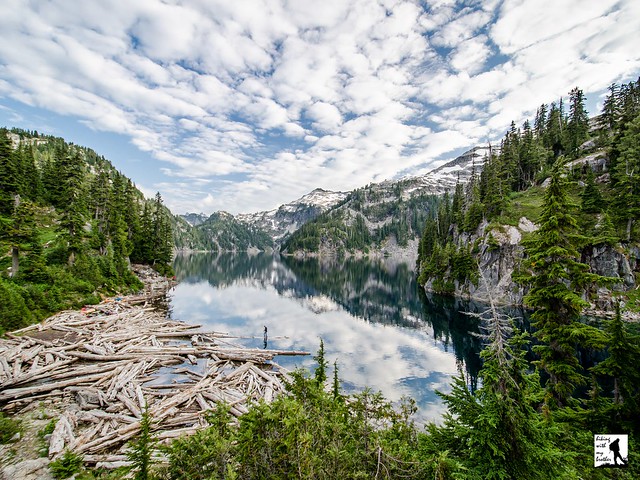
 The trail from Little Heart Lake to Big Heart Lake is the most challenging portion of the route. Not only does it come late in the hike, but much of the steep ascent is along exposed rocky slopes that offer big views, but little protection from the sun. The trail passes through talus fields and passes by any number of small tarns as it relentlessly pushes upward. After a little over a mile of climbing, the trail crosses over the ridge and begins quickly switchbacking down toward the lakeshore. Suddenly the trees pull away and Big Heart Lake lies sparkling before you, its shores a tangle of grey rock, bleached driftwood, vibrant evergreens and snowy ridgelines. Settle in to enjoy the view. If you’re camping, continue on the trail as it drops down to the water and crosses over a wide expanse of driftwood. From here, the trail begins to climb up a small hill. Start looking for a campsite as there are quite a few spots tucked into the hillside.

To get there, take Highway 2 out past Skykomish just beyond milepost 50. Take a right onto FR 68, also known as the Foss River Road. Continue on the road for 4.7 miles (the road becomes gravel after about a mile) to a junction with FR 6840. Veer left and follow FR 6840 for just under two miles to the end of the road and the West Fork trailhead. -Nathan
Print Google Directions >>
2 Comments:
I just love your landscape photographs!! What camera/ or how are you taking/ what are you doing to your images? Thanks for the great reports on local hikes!
Hi Katie, I'm glad you like the photos! Most of the photos are taken with a Nikon D7000, often using a polarizer with touch-up work done in Adobe Lightroom. :)
Post a Comment