


Total Ascent: 4200ft
Highest Point: 5500ft
Total Distance: 13.6 miles
Location: N 47° 29.1540, W 120° 44.9100
Required Permit: Northwest Forest Pass, Enchantments Permit for overnight stays
Difficulty: Hard
 One of our backpacking excursions last fall took us into the Alpine Lakes Wilderness and up to The Enchantments. While we have backpacked through the region before, this was the first time we have been able to experience the fall colors and the changing of the seasons. Our approach took us up to Snow Lakes, a popular stopover point for those heading up to the Enchantments Basin.
 Back in the 1930s the construction of the Grand Coulee Dam had an immediate impact on salmon runs. The Bureau of Land Reclamation worked to solve the issue through fish hatcheries, one of which was built on Icicle Creek to release into the Wenatchee River below the dam. Unfortunately, the Bureau quickly realized that fluctuations in the water levels of Icicle Creek would cause problems for a sustainable hatchery. The problem was a lack of cold water; the solution was to tap the nearby Snow Lakes seven miles upstream.
 In 1938 the Forest Service cut a trail up to Nada Lake and the Snow Lakes and a base camp was established on Nada Lake. From 1939-1942 crews worked to drive a 9-foot wide, 2,250-foot long tunnel through solid granite under Lower Snow Lake to the bottom of Upper Snow Lake. At the same time, a small dam was constructed to regulate the water levels between the upper and lower lake. Today, water drains from the bottom of the 150-foot deep Upper Snow Lake to a bulkhead where it is funneled into a pipe and shot out toward Nada Lake. A series of valves controls the amount of water discharged. On average the system is in operation 77 days a year, usually between July and October, and releases an average of 3,700 acre-feet of water.
The hike to Snow Lakes begins from the parking lot by following a maintenance road over Icicle Creek and past concrete canals. From the road the trail begins a slow switchback up into the sloping canyon. As you climb, evidence of the fires that ravaged the area in 1994 can still be seen. The skeletons of charred trees line the trail, though after nearly 20 years the underbrush has obscured much of the damage. However, the underbrush has yet to grow up enough to provide much in the way of shade, so this first section of the hike has a lot of sun exposure, making it hot and dusty during the summer.
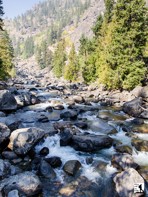
 As you leave the burn area and the faint smell of ash behind, the trail enters a pine forest and bends closer to Snow Creek, providing access to occasional creekside rest stops. Around the two mile mark the trail meanders past large cliff faces that are frequented by rock climbers and soon begins to veer up the rocky canyon slopes. Continue another two miles through talus fields, scattered sections of forest and brush-lined sections of trail to the sturdy footbridge crossing Snow Creek. Soon find yourself sharing the trail with Nada Creek as you push up to the marshy end of Nada Lake. While most hikers press onward to Snow Lakes on their quest to reach the Enchantments Basin, some choose to overnight in the quiet solitude of Nada Lake. Several campsites line the lower section of the lake. If nothing else, the shores of Nada Lake are an excellent resting point to recharge for the final push to Snow Lakes a mile and a half up the trail.
Continuing onward, the trail quickly and steeply rises up the slopes above Nada Lake. If water is being released from Snow Lake, you will see the spray gushing from the cliffs above Nada Lake. As you get closer, at a switchback in the trail, a bootpath leads out to the tunnel and the control valves for the drainage system. Push upward through rocky terrain to the relief of the forests that surround Snow Lakes. The trail leads across the small dam that controls the water level between the lakes. Depending on the time of year, Upper Snow Lake may be quite low, exposing sandy shores covered in the bleached wood of fallen trees. The craggy heights of The Temple rise dramatically above Upper Snow Lake creating a scene that epitomizes the Alpine Lakes Wilderness. Many campsites can be found around both lakes.
 Snow Lakes is a decent backpacking destination unto itself, though most folks undertake the dusty trek with the intent of pushing upward into the Enchantments Basin. Because permits to overnight in the core Enchantments Zone can be hard to come by, the Snow Lakes make a perfect base camp for day hiking the area by using the more easily obtained overnight Snow Lakes Permit. Somewhat challenging, this trip is best taken in the company of those with at least some wilderness and backpacking experience. It can be done as a long day hike, though we recommend against it. The difficulty of the trail on a hot summer day combined with the chance that Upper Snow Lake could be low and somewhat less than majestic probably makes this a little too much effort for one day. Save this one for a short overnight or as part of your exploration of the Enchantments Basin.
To get there, take US 2 to Leavenworth. Just before you enter town, take a right onto Icicle Creek Road (FR 76). Follow Icicle Creek Road for just over four miles to a large parking lot on your left. Park and find the trailhead at the far end of the lot. -Nathan
Print Google Directions >>
4 Comments:
Gorgeous. We went to Snow Lake in October of last year but started at the Alpental end of the trail. Shorter hike and still stunning.
Different hike, I think.
I have permit for this trip 9/17/15. When was your trip for the fall colors mentioned?
We went up the first couple of days of October, you should be hitting fall color by 9/17 - especially with the warm year we are having.
Post a Comment