


Total Ascent: Lake Lillian 1040ft; Full trip 2200ft
Highest Point: Lake Lillian 4800ft; Mt. Margaret 5560ft
Total Distance: Lake Lillian 1.75 miles; Full trip 5.3 miles
Location: Lake Lillian N 47° 23.9460, W 121° 20.3700 Mt. Margaret N 47° 22.9920, W 121° 20.3580
Required Permit: None
Difficulty: Hard
 We’re always looking for ways to extend a hike to nearby peaks and lakes. Often, when trying to dig up more information on a hike, we’ll stumble across new trailheads and alternative approaches. This is exactly what happened when we were contemplating a climb to the top of Mt. Margaret –
 a trip that would require re-hiking the Lake Lillian Trail #1332. Instead, we found an unofficial “shortcut” trail to Lake Lillian, which allowed us to access the mountaintop from an entirely different direction with less mileage. Happy to be breaking new ground, we packed up and headed out to Hyak.
Unsurprisingly, the unofficial trail is rough and haphazardly scraped into the mountainside. The steep half-mile to Lake Laura and the main trail follows Rocky Run Creek past slide alders, devil’s club and the occasional hemlock. The creek sports a couple of impressive cascades that are easily accessed and worth the short diversion. As the trail briefly plateaus, a spur leads down the few hundred yards to Lake Laura. Access to the lakeshore is limited, but clambering on the rocky cliffs for a better view of the waterfall were enough to tempt us down to the water.
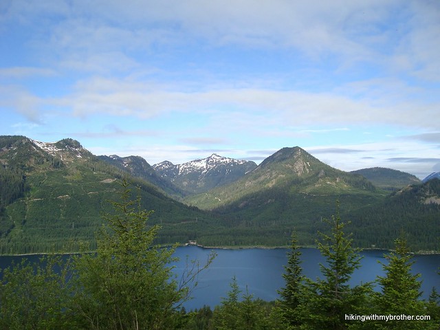
Whether you take the side trip down to Laura or not, the path quickly connects with the Lake Lillian Trail. From here, you have a choice; push up the short distance to Lake Lillian or head right toward Mt. Margaret. The placid waters of Lake Lillian sit beneath Rampart Ridge, quietly
 fueling Rocky Run Creek. It is possible to skirt the edge of the lake and slog up the ridge to Rampart Lakes and on to Alta Mountain. However, when the lake is high from snowmelt, the shoreline is fairly steep and requires some careful footwork to get around.
If the sun is shining and you’d like a view, head up to Mt. Margaret. Now on a refreshingly well-maintained official trail, the hike becomes easier. In a half-mile you’ll hike past Twin Lakes and look up to the rocky top of Mt. Margaret. From here, begin switchbacking up the shoulders of Margaret until the trail levels out and begins to traverse along the mountainside. Keep an eye out for a faint spur trail following a ridge to the summit and follow it to the top. Once there, find Laura, Lillian and Twin Lakes on display below. On the other side, Margaret Lake sits at the base of the mountain, with Stonesthrow Lake a little further beyond. Sit back and enjoy the quiet.
This is a fun little approach to Lillian, which is a nine-mile hike from the official trailhead. It’s on the more difficult side, but it is a great alternative to the more popular route. If you’re going purely for Mt. Margaret, the official approach is probably more efficient,
 but includes walking along gravel logging roads and lengthy stretches through recent clear-cuts. Although the road to the shortcut trailhead is currently a bit overgrown, the scenery is much more pleasant from this approach. You’re also unlikely to run into too many other people, as most hikers opt for the traditional trailhead.
To get there, take I-90 to the Hyak Exit 54 and take a left. As you pass under the freeway take a right on the frontage road. Follow the road for about two and half miles before it becomes the graveled Forest Service Road No. 4832. Follow FR 4832 for a mile or so to an intersection. Head left onto an unmarked road, labeled FR 136 on maps. Follow the increasingly overgrown FR 136 for about two miles until you get to a major switchback and a small parking area. - Nathan
2 Comments:
Hi, Nathan
My friend and I are planning to hike Mount Margaret tomorrow and would like to take the direct route per your suggestion. I've been trying to dig up more trip reports about the direct route to the summit, but neither WTA or Trails.com shed any light. Is the trail head for the direct route the same for the indirect route you and Jer took? Or will the Lake Lillian/Margaret Lake trail head on FR 4934 lead us to the summit of Mount Margaret. We'll take any guidance you can send our way, for your blog frequently leads us to our next trail. Hiked Kendall Peak Lakes two weeks ago on your suggestion and loved it!
Thank you!
Kathleen
Kathleen -
If the summit of Mt. Margaret is your sole destination, the faster route is the traditional one we describe here:
http://www.hikingwithmybrother.com/2009/10/margaret-lake.html
It's fairly well signed and a bootpath will lead you to the top. However, while this approach has the appeal of ample parking and a well maintained forest road to the trailhead, it does involve quite a lengthy stroll through barely recovering clearcuts.
The approach we describe in this post is a little longer and more challenging than the traditional approach it is a lot prettier. You also have the opportunity to check out a lot more lakes. But, as we caution above, it's on the rough side and the road to get there is less well maintained - we posted this on our Facebook to let people know:
http://www.youtube.com/watch?v=I-OCLgFqJ3E
Past Twin Lakes you'll climb up onto the shoulders of Margaret and traverse to the bootpath you would take along the traditional approach. You can see it on the map above as well as the "hook" at the end. And it's the actual trail.
When we did it, there was enough snow that we could take the closer ridge to the top. This type of route finding is easier to do with a GPS so if you don't have one, the traditional route is easier, but the "shortcut" approach should still be fairly intuitive.
Hope that helps, let us know if you have any more questions!
Post a Comment