


Total Ascent: 2900ft
Highest Point: 3900ft
Total Distance: 8 miles
Location: N 47° 30.6900, W 121° 32.0220
Required Permit: Northwest Forest Pass
Difficulty: Hard
Note: The Middle Fork Road is only open on weekends through 2016.
 We have spent a fair bit of time in the Middle Fork Snoqualmie Valley and trekked down many of the well known trails. We've also explored some lesser traveled areas and one of our favorites is Rainy Lake. Sometimes we are in the mood for something with a bit of grit to it, something that might require a little bushwhacking to complete. The Rainy Lake Trail is exactly this type of trail - perfect for hikers who are looking for a good workout and a little adventure.
The trail begins at the Middle Fork Trailhead, crosses the Gateway Bridge and veers right onto the newly upgraded Pratt Lake Connector Trail. As you leave the bridge, enter the Alpine Lakes Wilderness and follow downstream toward Stegosaurus Butte. From the new trail you can see the old riverside trail below, and after .25 mile stroll you'll reach a bridge spanning Rainy Creek. Cross the bridge and a few dozen feet beyond you'll find the unmarked junction with the Rainy Lake Trail. Head uphill, trading the wide trail for more difficult terrain.

This is a difficult hike. Not only is it a lot of elevation, but the route is rough and not for everyone. Be prepared to occasionally use your hands to find some balance and make sure to bring some poles to help keep you steady as you work your way up the steep creek valley. Those willing to brave the trail can look forward to the quiet solace of this pristine alpine lake. Certainly, Rainy Lake would be a great base camp for those that want to summit Preacher or the Pulpit, but it is also a lovely and peaceful destination in itself. Whether you're looking for something a little different or just looking for some solitude, Rainy Lake is a great choice.
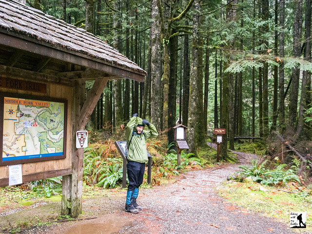
 To get there, take Exit 34 off I-90 and take a left on 468th Ave. Follow the road past the truck stop for about a half-mile until you reach SE Middle Fork Road, also known as Forest Road 56. Turn right and follow the road for a few twists and turns, keeping left when the road splits. After 2.2 miles reach SE Dorothy Lake Road. Take a left, passing the Mailbox Peak Trailhead as you navigate the nearly 11 miles of forest road to the Middle Fork Trailhead. The road is currently in the process of being upgraded and paved and is only open to the public on the weekend. The project is expected to be completed by fall of 2016. The signed trailhead and ample parking area is on the right side of the road, find the trail to the Gateway Bridge at the north end of the lot. -Nathan
Post updated 10/10/2015
Print Google Directions >>
3 Comments:
These are old directions to the trail.
They have made improvements to this area, so the trail is much easier to find.
After leaving the Middle Fork trailhead parking lot and crossing the big bridge, turn right at the T. (same as before)
Go down this trail and you'll cross over a newly built bridge.
a little after this bridge, on the left is the trail head to Rainy Lake.
Awesome trail!!
Thanks for letting us know this Brian - we went back this weekend to get the directions right. We've made some initial corrections to make sure folks can find the trail, and later we'll update the map and photos. And we couldn't agree more; this is a really fun and excellent trail!
Me and my brother and his son were up there before 2000. He, my brother and his son, made several trips up there. His son Isaiah crossed the Rainy Lake Creek and he was up to his chest in water. When I was up there, several times, it had improved with crossing the creek with logs and not by going through the water. A very challenging hike. I remember going up the side of hill with little to no trail. We reached a part where the ground had leveled out and there was no path that we could find. We gave up and turned around.
Post a Comment