


Total Ascent: 300ft
Highest Point: 2300ft
Total Distance: 4.0 miles
Location: N 48° 1.6020, W 121° 26.6340
Required Permit: Northwest Forest Pass
Difficulty: Easy
 Last fall, just before the snows closed the Mountain Loop Highway for the winter, we headed out to Barlow Pass to hike up to Barlow Point, the site of a former fire lookout. While we were there, we also rounded out our exploration of the area by trekking down the Old Government Trail #733.
 The Everett and Monte Cristo Railroad reached Barlow Pass in late 1893, largely following the rough roads and trails blazed by prospectors and explorers to bring supplies out to Monte Cristo. As workers neared the Pass, they ran into a rocky outcropping blocking the route. Undeterred, they blasted a gap through the rock wide enough to lay track and moved on. That gap is now known as the Barlow Cut. With Monte Cristo’s burgeoning mining operations now connected to the smelters in Everett, a steady stream of trains kept the tracks busy. All that increased traffic led to predictable results. In 1905, as so often happened in that era, a spark from a locomotive started a forest fire near the tracks, which quickly spread, eventually climbing up the mountainsides of nearby Mt. Dickerman. Today, you can still find burnt stumps along the Old Government Trail as lingering evidence of that fire.
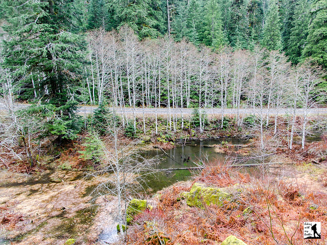
 Starting from the parking lot at Barlow Pass, the trail begins under a heavy canopy of fir and hemlock. After a third of a mile, the nearly flat trail encounters a junction with the Barlow Point Trail. Veer left, heading downhill and following the sign pointing toward the Old Government Trail. The fern-lined trail quickly descends down toward the railroad grade. The trail parallels the highway, which is partially obscured by foliage in the spring and summer but a fairly constant companion in the fall, and wanders past moss-covered cliffs and boggy marshes as it travels across talus fields. Rocks from these fields were used to build foundations that supported locomotives filled with coal and ore. Continue onward until you reach a set of small waterfalls near the end of the trail.
At this point, you can continue on the trail down to the Mountain Loop Highway, and walk it back to the parking lot for a loop, or just stop for lunch and head back along the trail. If you’re up for it, there is some extra exploring that is possible along this hike – you can leave the trail at certain points and connect with sections of the railbed. Here you will find the Barlow Cut and a small interpretive sign outlining some of the area’s history.
 This is a very short hike, and it is probably best combined with a short trek up to Barlow Point, as they make for a full day of hiking if taken together. An easy hike for all ages, Old Government Trail isn’t spectacular, but it’s very accessible and together with Barlow Point gives hikers a taste of more challenging hikes in the nearby Monte Cristo area. Next time you’re out at Barlow Pass, consider adding a short side trip down the Old Government Trail #733.
To get there, take I-5 North to Exit 194. Follow Highway 2 for about two miles. Stay in the left lane and merge onto Lake Stevens Highway 204. Follow for two miles to Highway 9. Take the left onto Highway 9 toward Lake Stevens. In just under two miles, you’ll reach Highway 92 to Granite Falls. Take a right and follow for about nine miles to the Mountain Loop Highway. Take the MLH for 31 miles to Barlow Pass. Find the trailhead parking lot on your left. -Nathan
Print Google Directions >>
0 Comments:
Post a Comment