


Total Ascent: 1000ft
Highest Point: 1560ft
Total Distance: 8 miles
Location: N 47° 30.6960, W 122° 1.8240
Required Permit: Discover Pass
Difficulty: Easy
 A few readers have written to us mentioning that we had given Squak Mountain short shrift with our single exposure to the tamest portions of the park on a rainy day. Finding ourselves in the mood for a short hike this week, we decided to give Squak another chance, albeit still on a very wet and rainy day. Ignoring the popular trailheads, we instead headed to an obscure entrance point off the Issaquah-Hobart Road. We hoped this would give us direct access to those “wild” portions of the park both Harvey Manning and our readers hinted at.
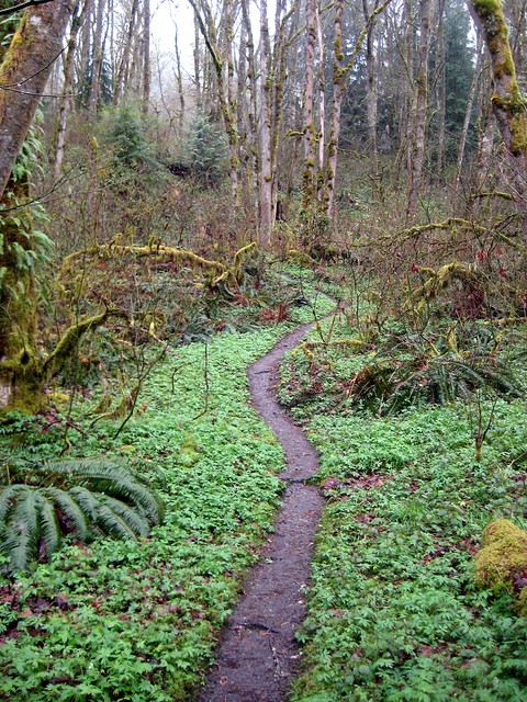
 This area of the park does, in fact, have a different feel to it. Squak was never logged to the same degree that Tiger and Cougar have been, and while there is clear evidence of logging in the form of large decaying tree stumps, most of the park has been sheltered from the axe for quite some time. This is largely due to the explicit restrictions the Bullitt family placed on the use of the 590 acres they donated the State of Washington back in the 1970’s that became the heart of the now much larger Squak Mountain State Park. Logging and motorized vehicles are prohibited in most of the park, something of a contrast to the “working” forests of Tiger and Cougar.
We found ourselves hiking merrily along a snow-free path towards Phil’s Creek, the arbitrary destination we’d chosen out of a hat. With so many little side trails and loops to explore there
 was a lot of opportunity to change our minds if we didn’t like where we ended up. Despite the rain, the lushness of the woods in the springtime was a welcome experience. After weeks of snow and lifeless bramble, leaves are appearing and flowers are already budding. As we switchbacked up Squak on the East Ridge trail, we occasionally caught a foggy glimpse of the surrounding mountains through peek-a-boo portals in the forest wall. We found Phil’s Creek and followed it to the park boundary, enjoying a landscape that fluidly transitioned from dense second-generation firs and pines to marshy wetlands and stands of alder.
Lots of activity and trail improvement is currently underway, so expect to see some volunteers improving the path and repairing some of the washed-out and damaged sections of trail. We still found Squak to be a great choice for trail running or a casual stroll; we also discovered some of the many equestrian trails that the park also has to offer. Squak definitely had some more to offer us on a rainy day than we had given it credit for, and with over 1,500
 acres to tromp through, there’s still more to explore.
To get to the trailhead we used, take I-90 to Exit 17 and take a right on Front Street. After you pass through downtown Issaquah and just before Front Street becomes the Issaquah-Hobart Road, keep an eye out for Sycamore Drive on the left. Follow Sycamore Drive as it twists itself into Hillside Drive and finally Crystal Creek Circle. You’ll see a gravel path between the houses barred by a couple of wooden posts with white painted tops on your left. Park along the street and head up. - Nathan
Print Google Directions >>
0 Comments:
Post a Comment