Total Ascent: 5800ft
Highest Point: 8450ft
Total Distance: 16.2 miles
Location: N 47° 28.0740, W 120° 48.8700
Required Permit: Northwest Forest Pass, (See overnight permit information below)
Difficulty: Hard
 Last summer we visited The Enchantments via Colchuck Lake and Aasgard Pass. Among our stops was the summit of Little Annapurna, one of a number of prominences surrounding the Upper Enchantment Lakes. A climb to Little Annapurna’s summit is rewarded with breathtaking views in every direction and offers one of the better vantage points to see both the Upper and Lower Enchantment Lakes that together make up the Enchantment Basin.
 The first recorded ascent of the mountain was in 1947, when it was dubbed “Little Annapurna” by the Sherpa Climbing Club of Ellensburg for a resemblance to the Annapurna of Himalayan fame. Little Annapurna is often accessed from Colchuck Lake via Aasgard Pass (officially named Colchuck Pass), a low saddle between the shoulders of Enchantment Peak and Dragontail Peak. The pass was likely named by Bill and Peggy Stark, who first visited the region in 1959. The couple returned every year for the next 35 years, naming features along the way, and ultimately drawing a topographical map labeling those features in 1967. While the US Board of Geographic Names officially adopted some of the Starks’ names, they did not adopt them all. However, many hikers and hiking guides prefer the Norse and Arthurian names chosen by the Starks, and their references to them can confuse the uninitiated. We use both for clarity.
From Colchuck Lake, continue following the Colchuck Lake Trail #1599.1 (sometimes referred to as #1599A) around the lake toward the base of Aasgard Pass. As you round the lake, the trail snakes into a talus field and the route moves from the ground to the tops of massive boulders. Alternate between the rocks and short sections of narrow trail hacked through the lakeside brush to the base of Aasgard Pass. From here the route becomes challenging. The route is steep and can be treacherous under certain conditions, as most of this portion of the trail is boulder and scree. Some route finding skills will be needed as shifting rock can topple cairns and obscure the trail. Unless you have a lot of experience and training, avoid an ascent in the snow.
From the base of the pass follow the cairns as they charge steeply upwards and to the left, passing over a creek buried under the rocks and eventually reaching the left cliff face. From here the route pushes further up and drifts back toward the center of the talus field, eventually crossing a small grassy meadow complete with a waterfall. Keep climbing upward, keeping an eye out for cairns on this last and often confusing section of trail. Eventually you’ll catch glimpses of Little Annapurna peeking over the top of the pass just before you reach the top. Take a moment to look down at Colchuck Lake shimmering over 2000 feet below before turning for your first glimpses of the Upper Enchantment Lakes.
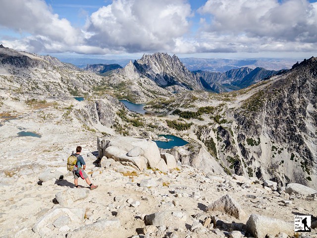
 From Aasgard Pass, the trail enters a grey moonscape of talus, rock and glacial till, contrasting with the stark white of the Snow Creek Glacier and the icy blue of the lakes. Press onward and quickly find Tranquil Lake (Lake Freya) and a view of the largest lake in the Upper Enchantments, Isolation Lake (Brynhild Lake). From here the trail begins to descend deeper into the basin, passing lakeshores and eventually depositing you into sprawling alpine meadows riddled with ponds and streams. The Starks called this area the Brisingamen Lakelets, and we can only call it enchanting. As you near the end of the meadows, keep an eye out for an unsigned trail heading to the right toward Little Annapurna. If you cross a small stream and a sign for the toilet, you’ve gone too far.
The route up Little Annapurna is more of a collection of well-worn paths than a trail. Cairns mark the way, though they are easy to lose and sometimes mark multiple routes. When in doubt, follow the path of least resistance up the left side of the mountain, switchbacking and scrambling as needed. Eventually you will be rewarded with commanding views of the Enchantment Basin: Dragontail Peak is to the northwest along with Aasgard Pass and Mt. Baker in the distance. Find Enchantment Peak directly to the north, with Prusik Peak and the Temple to the northeast rising above portions of Perfection Lake (Rune Lake). To the east McClellan Peak looms above Crystal Lake. Immediately to the south find the sharp points of Pennant Peak and The Flagpole with Mt. Rainier in the distance. Turn to the west to find Mt. Stuart and Argonaut Peak just to the left of Dragontail Peak. Do a little exploring and find your favorite vantage point to take it all in - you’ve earned it.
Little Annapurna is one of the most approachable peaks in the Upper Enchantment Lakes area. While the trail is sometimes thin or nonexistent, the climb is not technical and there is a minimum of actual scrambling. In the summer, the grassy summit offers plenty of room for hikers to find a quiet place to enjoy the scenery or spend the night. At the same time, this climb is not for everyone. If you’re not comfortable with some route finding and some scrambling, you may want to skip this one. Otherwise, we recommend you set aside enough time for a trip up Little Annapurna during your next visit to the Enchantments.

To get there, take US 2 to Leavenworth. Just before you enter town, take a right onto Icicle Creek Road (FR 76). Follow Icicle Creek Road for just over eight miles to Eightmile Road (aka FR7601). Turn left and follow the gravel road over Icicle Creek for about 4 miles to the road’s end and the parking area for Colchuck Lake and Lake Stuart. Trailhead at the far end of the lot. -Nathan
Print Google Directions >>