


Total Ascent: 2900ft
Highest Point: 5100ft
Total Distance: 7.4 miles
Location: N 47° 16.2659, W 121° 8.1180
Required Permit: None
Difficulty: Hard
 A few weeks ago we headed back over Snoqualmie Pass to further explore the ridges and mountaintops between Kachess Lake and Cle Elum Lake. On our last hike up Easton Ridge, we passed the junction for the Domeire Divide Trail #1308.2 and resolved to come back to see where it led. After some quick research, we were able to trace a route up to a former fire lookout site known as Old Baldy and returned to look for some big views.
The trail begins from the parking area, marked by a ragged sign pointing toward Trails #1212 and #1315. Find the well signed junction for the Kachess Ridge Trail #1315 just a few feet down the trail. Ignore this junction and instead veer to the right toward the sound of Silver Creek and an unmarked trail dropping down to the water. This is the Easton Ridge Trail #1212. Head to the creekside and soon find a sturdy bridge crossing the water at the base of the irrigation dam. Cross the bridge and climb a few switchbacks up the ridge to the bones of an old forest road. Follow the fading road for a few hundred feet before finding an obvious but unmarked trail heading up the mountainside.

From here, the trail continues to climb through a forest of pine and fir, offering occasional glimpses of Kachess Lake and Kachess Ridge. After 1.3 miles of hiking you’ll attain the ridgeline and arrive at the junction with the Domerie Divide Trail #1308.2. Head left and enjoy a short respite from the climb as the trail meanders along the ridgeline. Soon the route swings uphill and the real climbing begins. Gone are the switchbacks of the lower trail, replaced instead by steeps sections that tackle the climb head-on. Keep in mind that during the summer months, the fine dust of the trail can make for a somewhat slippery climb. As you press ever upward, the trees thin somewhat, providing ample opportunity to take in the surrounding landscape as well as Mt. Baldy in the distance.
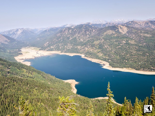
Eventually, after more than a mile of climbing, you will attain another ridgeline and find the junction the Domerie Peak Trail #1308. Head right, following the trail as it dips downhill and soon reveals big views of Cle Elum Lake and a sea of peaks and crags. Press onward following the ridge toward the barren summit of Mt. Baldy. Once you reach the base of the summit, the trail turns sharply uphill and begins to fade. If you’re not exactly sure where the trail is, simply keep climbing. Before long, find yourself at the former lookout site, with big 360-degree views. To the north you can easily pick out nearby Red Mountain, with Mt. Daniel and Glacier Peak rising in the distance. Turn east to find Jolly Mountain and Hex Mountain just above Cle Elum Lake, with Mt. Stuart beyond. The plains of eastern Washington stretch toward the horizon as you sweep southward over neighboring Domeire Peak to take in Mt. Rainier. Complete your turn to pick out Silver Peak, Abiel Peak and other Snoqualmie Pass peaks to the northwest. Settle in and break out your map to see how many more peaks you can find.
 Steep, long and a little rough, this hike isn’t for everyone. At the same time, it’s not at all surprising that a fire lookout was located here for two decades. The views are enormous and because the trail is on the challenging side, you’re likely to be enjoying the scenery without much company. This is a great choice for those looking for a training hike or an alternative to nearby Kachess Ridge or Easton Ridge.
To get there, take I-90 to Exit 70. Take a left over the freeway and turn left onto West Sparks Road. Continue for a half-mile to FR 4818 (signed Kachess Dam Road) and take a right. Follow FR 4818 for a mile to an unmarked road on the right. Follow this road for a half-mile to the small parking area at the trailhead. -Nathan
0 Comments:
Post a Comment