about us | links | permit info
Subscribe to Hiking With My Brother Email Subscribe Follow Hiking With My Brother on Facebook Follow Hiking With My Brother on Twitter Hiking With My Brother Picasa Hiking With My Brother YouTube

Marten Creek Trail #713

Our Hiking Time: 4h 45m
Total Ascent: 1400ft
Highest Point: 2800ft
Total Distance: 6.6 miles
Location: N 48° 6.2640, W 121° 37.3320
Required Permit: None
Difficulty: Hard (Overgrown after 2.0 miles)

Nathan's Photo
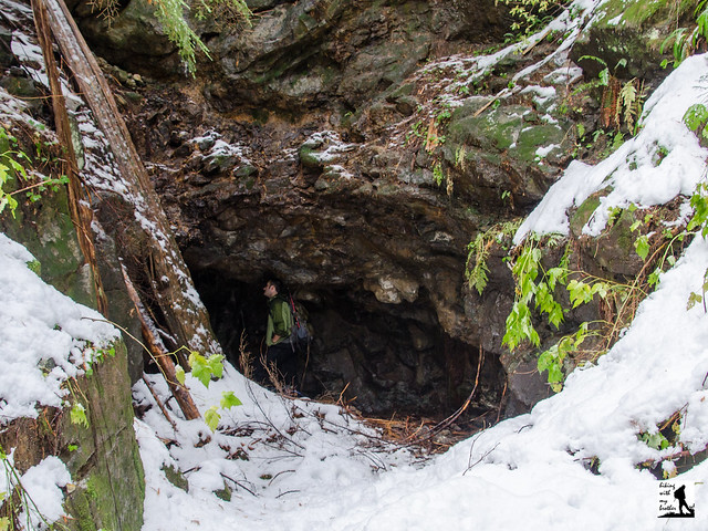
A few weeks ago we headed back out the Mountain Loop Highway to the Marten Creek Trail #713, an all-but-forgotten mining road that once connected Silverton with Darrington over Granite Pass. We expected to find a trail leading out to an old mine, but instead we were confronted with a bit more route-finding and bushwhacking than we anticipated.


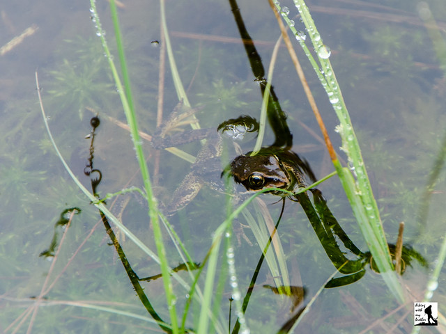
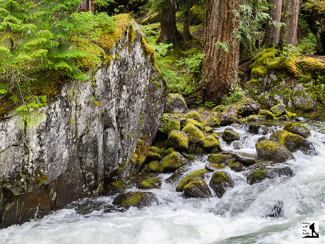
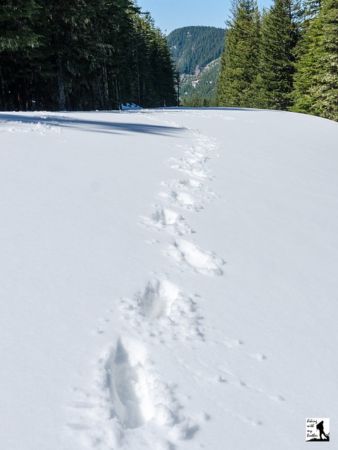
If you’re looking for a training hike or a quiet snowshoe without a lot of company, the Marten Creek trail is an excellent choice. Although there is not much in the way of a destination, the first two miles of this trail offer forested trails, a roaring creek, some views and more than a little history. Much beyond this point most folks are unlikely to enjoy the hike, at least until the trail gets some serious trail maintenance. Because of this, we recommend you save this one for snowshoe season, as it makes a great alternative to the more popular routes along the Mountain Loop Highway.

There's a lot more to Marten Creek, and you can learn all about it in our book, Hiking Through History Washington.  You'll find a trail map, route descriptions, history, and more for this and many more hikes throughout the State. Help support hikingwithmybrother.com and the work we do by picking up a copy!

To get there, take I-5 North to Exit 194. Follow Highway 2 for about two miles. Stay in the left lane and merge onto Lake Stevens Highway 204. Follow for two miles to Highway 9. Take the left onto Highway 9 toward Lake Stevens. In just under two miles reach Highway 92 to Granite Falls. Take a right and follow for about nine miles to the Mountain Loop Highway. Follow the MLH for about 20 miles to the bridge over Marten Creek, just past the Marten Creek Campground. The signed trailhead is on the east side of the creek. There is no parking lot, find parking along the shoulder. -Nathan

Print Google Directions >>

Marten Creek

Colquhoun Peak Trail #1195

Our Hiking Time: 30m
Total Ascent: 600ft (900ft from FR7036)
Highest Point: 5200ft
Total Distance: 1.0 mile (2.0 miles from FR7036)
Location: N 47° 7.7520, W 121° 27.6720
Required Permit: None
Difficulty: Moderate

Nathan's Photo
Last week we decided to do a little exploring in the forests that surround Greenwater out along Highway 410. We had a couple of different trails and destinations we wanted to check out, including a return trip to Colquhoun Peak for a snow-free trek up the site of a former fire lookout. As we knew from our previous visit, this short hike offers some excellent views of Mt. Rainier and the White River Valley.

Although quite short, Colquhoun Peak makes a good addition to a day of hiking, delivering excellent views in a very little time. Combining a trip of Colquhoun Peak with a trek up Kelley Butte or Blowout Mountain can make for a decent day of hiking and exploring this area. While the trail is somewhat steep and a little rough, because it is only a half-mile, the trail should be approachable for almost any hiker. As an added bonus, this trail also does not see a lot of foot traffic, probably because it is a little tricky to find. So expect to savor Colquhoun Peak’s views without anyone else around.

One word of caution: the spur road to the trailhead is very narrow and is not wide enough for two cars to pass each other. Be careful if you chose to drive that half-mile to the trailhead, the road drops off steeply, and reversing down the rough road if you meet another car on your way up will be difficult. We recommend you park on the shoulder near the spur road and hike the road to the trail.

There's a lot more to Colquhoun Peak, and you can learn all about it in our book, Hiking Through History Washington.  You'll find a trail map, route descriptions, history, and more for this and many more hikes throughout the State. Help support hikingwithmybrother.com and the work we do by picking up a copy!

To get there, take I-5 south to Highway 18 Exit 142A. Follow Highway 18 into Auburn and take the SR 164 exit. Head left on SR 164 through Enumclaw to SR 410. Turn left onto SR 410 and drive about 20 miles through the town of Greenwater, past the fire station to FR 70 on the left. Take a left and follow FR 70 for about eight-and-a-half miles to FR 7030. Take a left and continue about four miles to FR 7036. Take a right and continue half a mile to unmarked Road 7036-110 on your right. It is a narrow, rough road that requires a high clearance vehicle. Either park at the junction and hike the half-mile to the trailhead, or drive to the end of the road and park in at the small turnaround at the end of the road. -Nathan

Print Google Directions >>

Colquhoun Peak

The 2013 Hiking with my Brother Calendar

Jer's PhotoAlmost every weekend for years, we have been trekking down hiking trails across Washington and reporting our experience on hikingwithmybrother.com. Now we've put together our 2nd annual calendar that draws on our all-season hiking experience. The Hiking with my Brother 2013 Calendar suggests a different hike every Saturday in 2013, each chosen with the season in mind. The calendar also showcases some of our best photography from the suggested hikes to inspire you to get out on the trail. Of course all the hike details, including directions, history, and photos can be found on hikingwithmybrother.com.

Check out the preview of the calendar below, and we hope you pick one up for you or a loved one this holiday season. Use Lulu.com promotional code NOVCALENDARS12 to get a 25% discount in the month of November! -Jer


Support independent publishing: Buy this calendar on Lulu.

Ashland Lakes Trail

Our Hiking Time: 3h 15m
Total Ascent: 800ft (500ft in; 300ft out)
Highest Point: 3000ft
Total Distance: 5.5 miles
Location: N 48° 1.6800, W 121° 43.7100
Required Permit: Discover Pass
Difficulty: Easy

Nathan's Photo
A few months ago we headed out on the Mountain Loop Highway to explore the Ashland Lakes Trail and the Morning Star Natural Resource Conservation Area (NRCA), one of Washington’s 30 NRCAs managed by the Department of Natural Resources. Boasting lakes, marshes, mountaintops, and old growth forest, the area promised a little bit of everything and managed to deliver.

Ashland Lakes have attracted hikers and campers for years, but it wasn’t until the late 1980s that steps were taken to protect the area. Around 1989 the Mt. Pilchuck Natural Resource Conservation Area was formed, preserving 9606 acres of land ranging from the top of Mt Pilchuck down the to shores of Ashland Lakes. The ecologically diverse area included alpine meadows and stands of old growth roughly 300 years old. In 2007, the Mt. Pilchuck NRCA was combined with nearby Greider Ridge NRCA and Morning Star NRCA. Now collectively known as the Morning Start NRCA, this 26000-acre conservation area provides a home to threatened species as well as a wide array of recreational opportunities.

The trail begins by following a logging road through a young forest of recovering clear-cut. Mostly wide and flat, this first mile or so of trail breezes quickly past grassy marshes and over a small creek before leaving the road and plunging into old growth. The change is dramatic. The forest closes in and trees loom above you as you cross planks spanning creeks, puddles and bogs. Stroll through lush undergrowth and past moss-covered rocks. Find the junction to Beaver Plant Lake branching off this network of boardwalks and take the short side trip out to this little lake before returning to the trail. As you continue, you’ll pass the junction to the Mallardy Ridge Trail leading out to Bald Mountain – an adventure for another day. Push ahead to Upper Ashland Lake.

Hugging Upper Ashland’s lakeshore, boardwalks lead you around the lake. Pass the occasional wooden platform built to allow campers to pitch a tent with the hope of staying dry on the lake’s soggy shores. After you’ve gotten your fill of Upper Ashland Lake, continue down another half mile to Lower Ashland Lake. Slightly less traveled than the upper lake, this tree-lined lake is a little wilder and you are less likely to encounter other hikers here. Continue to the end of the lake to find a log bridge spanning Wilson Creek and beyond another platform that makes for a good stopping point. The trail continues another mile and a half to Twin Falls Lake, but recent storm damage has washed out the trail and the Department of Natural Resources has closed the trail until further notice.

The Ashland Lakes Trail has the right mix of distance, elevation and destinations to make it ideal for bringing younger hikers along. The elaborate system of bridges and boardwalks also make this a fun hike for both new and experienced hikers. However, the area does receive quite a lot of rain – over 100 inches annually – which means you can almost always expect a little mud and that boardwalks will be a little slippery. Still, each of the three lakes has their own personality and offer a great deal to see on this relatively short and easy hike.

To get there, take I-5 North to Exit 194. Follow Highway 2 for about two miles. Stay in the left lane and merge onto Lake Stevens Highway 204. Follow for two miles to Highway 9. Take the left onto Highway 9 toward Lake Stevens. In just under two miles reach Highway 92 to Granite Falls. Take a right and follow for about nine miles to the Mountain Loop Highway. Follow the MLH for nearly 16 miles to FR 4020, signed for multiple trailheads including the Ashland Lake Trail. Take a right and follow the gravel road about two-and-a-half miles to a junction. Head right on to FR 4021 and continue for a mile and a half to a junction with Spur 016, signed for Ashland Lakes. Head uphill and find the trailhead at the top. - Nathan

Print Google Directions >>

Ashland Lakes

Deception Creek Trail #1059

Our Hiking Time: 4h
Total Ascent: 1100ft
Highest Point: 3000ft
Total Distance: 6.5 miles
Location: N 47° 40.5600, W 121° 10.8360
Required Permit: Northwest Forest Pass
Difficulty: Moderate

Nathan's Photo
A few months ago, we ventured out along Highway 2 in search of a suitable hike for the day’s rainy weather. After consulting a few guidebooks, we settled on the Deception Creek Trail #1059, a hike that promised creeks, lakes, and the shelter of old growth forest.

There are quite a few geographical features in Washington that have earned the name “deception.” Usually, this is because the feature caused some sort of confusion upon discovery. Puget Sound’s Deception Pass, for example, was named by Capt. George Vancouver because it first appeared to be a narrow bay rather than a passageway. Our efforts to dig up the story behind the naming of Deception Creek and the Deception Lakes the creek drains came up empty, but we do know it has been called Deception Creek for quite some time. Back 1893 the last spike of the Great Northern Railway was driven at Deception Creek, connecting Seattle to St. Paul, Minnesota. You can learn more about the role the Great Northern Railway played at Stevens Pass by exploring the Iron Goat Trail.

The trail begins beneath the crackle of power lines, but soon plunges into a mature forest of fir, cedar and hemlock. Almost immediately you’ll cross into the Alpine Lakes Wilderness and find yourself alongside Deception Creek. The first mile is fairly tame, climbing slowly but steadily up the valley. The somewhat narrow trail crosses over streams large and small, usually with a bridge or boardwalk to help you to the other side. Depending on the season, you may find that Deception Creek has spilled over onto the trail, and you may need to find creative ways of getting across.

After crossing the log bridge over Deception Creek, the trail steepens, pulling you up the mountainside high above the creek. Eventually the trail levels out and crosses over Sawyer Creek. At roughly three miles find a campsite well-suited for a break or a turn-around point for those looking for a shorter day. This was our stopping point, but you can continue on for another two miles to find the Tonga Ridge Trail #1058. For those looking to do some backpacking, the connecting trail to Deception Lakes #1059B is found at the seven mile mark and Deception Pass and the Pacific Crest Trail is beyond ten miles from the trailhead.

Surprisingly, the Deception Creek Trail does not get a lot of traffic. It’s among the least traveled trails in the Alpine Lakes Wilderness, despite lush old growth and the fairly impressive cascades of Deception Creek. Beyond our stopping point the trail leaves the shelter of the forest and opens into sub-alpine meadows with views of the surrounding mountains. With fairly easy access to the trailhead and moderate elevation gain, this is a decent hike for almost anyone. We also recommend this area for your next backpacking trip, as you’re likely to get Deception Lakes all to yourself.

To get there, take Highway 2 out past Skykomish just beyond milepost 56, just past the Deception Falls Interpretive Site to FR 6088 also known as Deception Creek Road. The road is not well signed, and can be easy to miss. Take a right and follow FR 6088 under the railroad trestle for about a half-mile to the trailhead. -Nathan

Print Google Directions >>

Deception Creek
Copyright 2008-2016 - hikingwithmybrother.com
hikingwithmybrother@gmail.com