Total Ascent: 1100ft
Highest Point: 5600ft
Total Distance: 8.5 miles
Location: N 46° 57.7080, W 121° 40.9203
Required Permit: None
Difficulty: Moderate
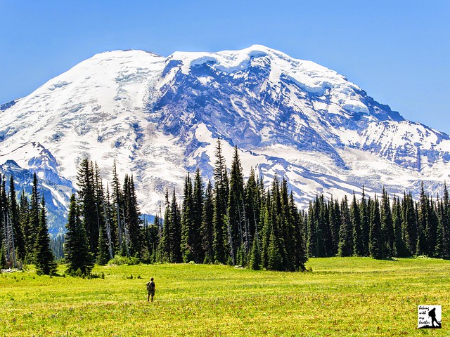
 Mt. Rainier National Park boasts dozens of hikes leading out to dramatic landscapes dominated by the looming volcano. Few are more iconic than Grand Park; a sea of meadows and wildflowers lapping at the base of Mt. Rainier. The classic approach from Sunrise is long and tough, putting Grand Park out of reach for most casual day hikers. Luckily, there is an unofficial “backdoor” approach via Lake Eleanor that allows many more hikers to enjoy this stunning destination.
The “backdoor” approach likely began as a boot trail used by fishermen to access Lake Eleanor. This 20 acre alpine lake and the creek that drains it were named around the turn of the 20th century by Burgon D. Mesler in honor of his wife Eleanor. The Mesler family were early settlers in the area, running an inn and other amenities that catered to travelers heading over the Cascades or visiting the park.
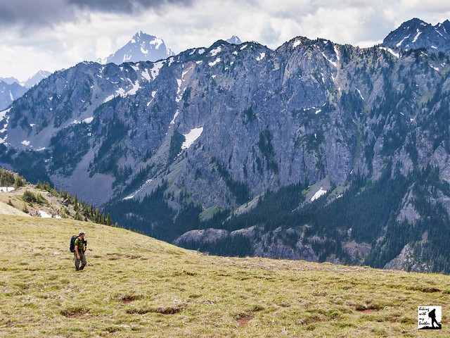
The hike begins just off FR 73, following a bootpath along the edge of Eleanor Creek. The trail enters a mixed forest and begins a moderate climb toward Lake Eleanor. Within a half-mile, you will cross into Mt. Rainier National Park and in another mile or so you will arrive at the lakeside. There are a few campsites around Lake Eleanor that provide nice views of the lake and a pleasant place for a snack, though most hikers will be eager to push on to the meadowlands ahead.
 From the lake the trail steepens and climbs through larger stands of hemlock and fir. The moderate climb is broken up by short wanderings through progressively larger meadows. Push onward and upward to the wide expanses of Grand Park. Often filled with wildflowers during the spring and summer months, the miles-long grassland can seem to be awash in color from the moment you arrive. Resist the temptation to linger at the edges, and continue on to the meadow’s highpoint for outstanding views of the mountain. Find a comfortable spot to settle in and soak up the panorama. If you're hungry for more you can continue all the way through Grand Park's meadows to connect with the North Loop Trail and the rest of the Wonderland Trail.
We highly recommend this approach to Grand Park. Not only is the trail fairly approachable for almost all hikers, but the Lake Eleanor route is usually accessible long after the road to Sunrise is closed for the season. Although the trail may have been difficult to navigate in the past, its popularity has brought thousands of boots to soften it up, and today the path is almost as well-maintained as an official trail. One word of caution: the area around Grand Park is the perfect breeding ground for mosquitoes and other bugs. Be sure to come prepared during the spring and summer months. If you haven’t made it out to Grand Park yet, add this one to the top of your list of future hikes.
 To get there, take I-5 south to Highway 18 Exit 142A. Follow Highway 18 into Auburn and take the SR 164 Exit. Head left on SR 164 through Enumclaw to SR 410. Head left onto SR 410 for 25 miles to Huckleberry Creek Road (FR 73). Turn right onto FR 73 and follow for 6 miles to cross the Huckleberry Creek bridge. Continue on FR 73 as it climbs for another 4 miles to the bridge crossing Eleanor Creek, which is signed. There is no official trailhead, but there is room for a number of cars to park. -Nathan
Print Google Directions >>