Total Ascent: 4000ft
Highest Point: 4841ft
Total Distance: 5 miles
Location: N 47° 27.745, W 121° 38.354
Required Permit: Discover Pass
Difficulty: Hard
 I can’t remember the first time I ever heard mention of Mailbox Peak and its fabled mailbox - it was certainly many years ago. But I definitely recall the most recent sermon from a talkative hiker during one of our many training forays up the Tiger Mountain Cable Line. Through some twist in small talk we touched upon our training for Rainer, and how we found the Cable Line to be the best mix of proximity and incline for our needs - we were immediately admonished for our misconception. “Oh no. Mailbox. Mailbox is way stepper than Cable Line, this is nothing. You should be training there,” the stranger scoffed, all but chuckling at our appalling ignorance.
After that interaction, Mailbox became a running joke between us – any hike banter was incomplete without at least one “you haven’t done Mailbox? What the hell is wrong with you?” exchange. With Rainer behind us, it’s not too surprising that we chose Mailbox Peak as one of the first hikes to tackle, after all, we’ve summitted Mt. Rainier, how hard could it be?
 Turns out? Mailbox Peak is, in fact, steeper than the Cable Line. Perhaps a bit less relentless, but it certainly makes you pay for the views it eventually gives up. It starts with deceptive simplicity; following a forest road up to the trailhead, at which point they attempt to scare you away with the pictured sign, and then winding through some innocuous low forest for about the first mile. Without fanfare, the trail morphs from a walk through the woods to 30-40 degree inclines, making climbing poles almost a necessity. Forest eventually opens up into some old burn, the lack of ground cover and uniformity of the terrain makes it easy to lose the trail if you’re not paying attention to the markers. Keep an eye on the reflective diamonds! If you haven’t seen one in awhile, you’ve gone off in the wrong direction.
Switchbacks wind up through the burn eventually opening up to salal and other sub-alpine scrub. Sky is suddenly visible and it’s easy to delude yourself that, after ascending 3000ft or so, you’d be near the end. You are wrong. There is more. Much more, as scrub opens up to a field of rocks and the summit. Or what you think is the summit. The trail continues up and around the rocks only to reveal that there is much more to go at 3800ft and that the true summit is still ahead.
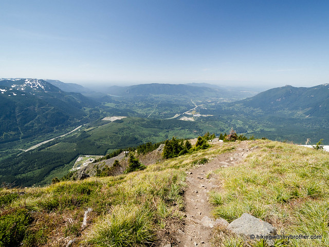
The ridge to the top is open and the wind had no problem attempting to trip us up, laughing as we fought to keep our balance. Upon reaching a rocky crag that again appears to be the finish line, the newest incarnation of the mailbox looms ahead. It is only at this point it is safe to conclude that you’ve laid eyes on your goal. Everything previously is a cruel tease.
The views here are excellent; on a cloudless day Seattle’s skyscrapers are
 visible in the distance, Rainier looms proudly to the south, Baker to the northeast opposite the tips of the Enchantments to the northwest. The mailbox will be filled with any manner of items, almost certainly some notebook to log your conquest, as well as a menagerie of clever offerings to the alter of Mailbox. So leave your mark and take a rest. Heading down is probably going to be worse. It’s only on the way down that you notice how truly steep the trail is. This is where poles are a must, if only to keep yourself from twisting an ankle or utterly destroying your knees. Roots and soft soil will work to trip you up, so be more vigilant than usual.
To get there, take I-90 to exit 34 and take a left onto 468th Ave. Follow the road past the truck stop for about a half-mile until you reach SE Middle Fork Road, also known as Forest Road 56. Turn right and follow the road for a few twists and turns, keeping left when the road splits. After 2.2 miles reach SE Dorothy Lake Road. Turn left and continue .3 miles find the road up to the parking area on your right. - Nathan
Print Google Directions >>