


Total Ascent: 1100ft
Highest Point: 5400ft
Total Distance: 3.4 miles
Location: N 47° 10.1580, W 121° 29.4180
Required Permit: None
Difficulty: Moderate
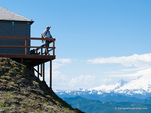
 Finding ourselves a little short on time this week, we headed out to Kelly Butte for a quick hike to up to a restored fire lookout. We navigated our way through a maze of logging roads to find ourselves rapidly climbing through fields of wildflowers toward expansive views of Mt. Rainier and the Green River Valley.
This is a fun little hike, quickly delivering a short workout and some views. Despite the steep start, this hike is approachable for almost every hiker. The most challenging part
 of this hike is actually finding it. There are quite a few unmarked logging roads to deal with, and it is fairly easy to get turned around. Once you find the road to the trailhead, we really encourage you to park at the makeshift lot near the Kelly Butte Trail sign. While you can probably make it down the somewhat overgrown road to the base of the butte, the road is extremely narrow and there are no pullouts, making it impossible for two cars to pass each other on it. If you happen to encounter another car going the opposite direction, one of you will have to reverse all the way to either end of the road to make room.
There's a lot more to Kelly Butte, and you can learn all about it in our book, Hiking Through History Washington. You'll find a trail map, route descriptions, history, and more for this and many more hikes throughout the State. Help support hikingwithmybrother.com and the work we do by picking up a copy!

To get there, take I-5 south to Highway 18 Exit 142A. Follow Highway 18 into Auburn and take the SR 164 exit. Head left on SR 164 through Enumclaw to SR 410. Turn left onto SR 410 and drive about 20 miles through the town of Greenwater, past the fire station to FR 70 on the left. Follow FR 70 a little over eight miles to FR 7030. Take a left onto the gravel road and continue about four miles to a T-intersection. Take a left and continue a mile to the next intersection, again veering to the left. Continue for about a half-mile to another intersection, this time heading right. Find the signed trailhead on the left in about a mile. -Nathan
Print Google Directions >>
0 Comments:
Post a Comment