


Total Ascent: 2700ft
Highest Point: 5464ft
Total Distance: 4 miles
Location: N 47° 47.4240, W 121° 36.7140
Required Permit: None
Difficulty: Hard
 This week, blue skies and warm weather lured us out toward Index to climb Mt. Persis, a seemingly short summit that’s been on our list for years. After winding our way up some rough logging roads, we found the unmarked trailhead and headed out on the rough bootpath for a hefty workout and some spectacular views.
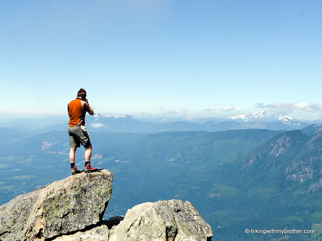
  The area around Index was first settled by Amos and Persis Gunn back in 1889. The area quickly became a stopping point for travelers, and the town of Index was platted in 1893. By 1907 the town was officially incorporated and Persis Gunn had named many of the peaks surrounding the growing settlement, including Gunn Peak, Mt. Persis, and the original Mt. Index (now called Mt. Baring). The first recorded ascent of Mt. Persis was in 1917 by Harry B. Hinman and his climbing party. Today, hikers continue to make the climb to the summit following an unofficial trail straight up the mountainside.
 From the beginning this trail is a challenge. It’s rough and difficult, traveling through young forest and clearcuts into older stands of cedar and Douglas fir that proved too difficult to log off the steep slopes. The first mile sees the most elevation gain, with the trail eventually leveling out at the first view of Index and the top of Persis. From there, traverse along the ridgeline, through
 talus fields and thinning trees before beginning the final leg of the hike. Push upward past two small lakes to the ridge that runs between Persis and Index. Veer left to climb to the top of Persis. If Mt. Index is your goal, head right and be prepared for a long day.
 Once you reach the summit of Persis, soak up the expansive views. Neighboring Index is massive. Pick out Baring, Mt. Baker, Gunn Peak, and Mt. Rainier. The exposed granite of the Index Town Wall is easy to spot above the miniature town of Index, and Heybrook Ridge sits just under Mt. Baring. The 360-degree views offer plenty to see before starting the steep slog back down the mountain.
We’ve probably already made this clear, but be prepared: this is not an easy hike. More a bootpath than a real trail, the route occasionally disappears in the undergrowth. The trail is also very steep in places, requiring a little help from nearby trees to make your way up. But the
 views are incredible - more than worth the effort it takes to make it to the top. Just don’t let the short mileage fool you, and plan on spending a few extra hours tackling this one.
 To get there, take US 2 about 33 miles and turn right onto Forest Road 62, just before the town of Index. Follow FR 62 about three and a half miles to a junction with FR 6220. Head left for a little over a mile to another junction, and then again veering left. Continue on the increasingly rough road for another mile, watching for a small pullout on the left just a few hundred feet from road’s end. A steep, well-trod gully opposite the pullout marks the trailhead. -Nathan
7 Comments:
Another fabulous trip!! Someday I want to tackle Mt. Persis.
Did Mt Persis yesterday. I'm 70 and couldn't find anyone who wanted to try it with me. Don't think I'd have been able to make it without the info you provided. Thanks for posting. Peter
Peter, Glad we were able to help get you to the top! Nice job, and thanks for reading the blog.
Jer, I got some pretty decent pics, but yours were even better... thanks again.
Post your pics on our Facebook Page. It would be great to see them!
Hi there, Would you consider this a scramble or just a very steep hike? Trying to decide if I should bring my small but athletic dog... thanks!
This is more of a very steep hike, though some call it a scramble. There are sections where it crosses talus fields that might be a challenge for your dog. Also, when we did hike this, most of the summit massif was covered in snow, which may have been covering some difficult terrain. Hope that helps!
Post a Comment