


Total Ascent: 1700ft
Highest Point: 1800ft
Total Distance: 4 miles
Location: N 47° 29.9730, W 122° 0.4870
Required Permit: Discover Pass
Difficulty: Moderate
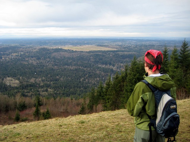
 Short on time this week, we returned to Tiger Mountain to explore the curiously named Poo Poo Point. Years ago, Harvey Manning decided to christen the area in honor of the “poo poo” sound made by logging steam whistles. These same whistles presumably helped create the large open fields at the top. Today, these fields are used as a makeshift airport for both hang gliders and paragliders, managing to accommodate both launches and landings.
Traditionally, the Poo Poo Point Trail begins at the Issaquah High School and gently meanders its way 4 ½ miles up to the top. Lacking the time for a 9-mile excursion, we opted to take the more
 direct Chirico Trail to our destination, located a few miles down the road from the high school at the paraglider landing field.
The short hike up the side of Tiger was reminiscent of the Cable Line: a narrow trail blazing its way to the top as quickly as possible. Despite the drizzle, we were joined by many a hiker and more than a few canine companions as we switchbacked through the young forest. We passed many lesser-used trails branching off; some reconnected back up with the main thoroughfare, while others disappeared intriguingly off into the distance. Feeling adventurous, we took one of these paths on our way back down. Unfortunately, our explorations spit us out miles from the parking lot, forcing us on an unpleasant walk down the busy Issaquah-Hobart Road to get back to the car.
The two landing fields offer great views of Squak, Cougar, and Lake Sammamish to the northwest, and Mt. Rainer to the southeast. Take some time to marvel at the Astroturf runway and what it would mean to take a running leap into the air from here. Though moderately steep, this trail is short enough to coax the whole family up, though the narrow trail often becomes slippery with mud after prolonged rain.
To get there, take I-90 to Exit 17 and hang a right on Front Street.
 Front will take you through historic Issaquah before changing into the Issaquah-Hobart Road. Continue for about five miles until you see a large grassy field and a parking lot on your left. This is the paraglide landing area. Park - trail begins on the other side of the field. - Nathan
Print Google Directions >>
3 Comments:
The trail was surprisingly busy for a Thursday afternoon, filled with kids and hang-gliders. It was in good shape, with one "danger soft sides" sign posted. Near the top the trail splits repeatedly to offer you one option straight up and one that has a slower incline. I have a feeling parking is harder on the weekend as many "no parking signs" are posted and flagged on the road.
Thanks for the trail map and great info.! We did this Chirico Trail to Po Po Point today (July 4, 09 Sat.) around 11 a.m., not too many people.
Great info and directions to the shorter Chirico Trail. We went on this chilly Friday morning in January (around 10am) and saw only a few others on the way up. There were many making the trek up to the top on our way down and the parking lot, while not completely full, was surprisingly active. It is horse accessible but our only excitement was a single pile of droppings.
Post a Comment