


Total Ascent: 1300ft
Highest Point: 5600ft
Total Distance: 2.6 miles
Location: N 47° 50.1900, W 121° 15.8340
Required Permit: None
Difficulty: Moderate due to steep terrain
 Not long ago, just before the snow firmed up its hold on the mountaintops, we headed out toward Stevens Pass to squeeze one more hike along Highway 2 into 2013. We had relatives in tow and needed a hike that was not too difficult, but also offered some decent views. We went with the obvious answer -- the popular Evergreen Lookout Trail which managed to more than deliver on its promise of big views.
Evergreen Mountain is named for the large meadows that cover the flanks of the mountain. Back in 1935, the US Forest Service built a fire lookout cabin on summit as part of its fire-fighting program. During the summer months, a lookout would watch for signs of smoke and radio the ranger station if they saw a fire. During World War II, the cabin was taken over by the Aircraft Warning Service, a band of civilian volunteers organized by the US Army to keep an eye out for enemy aircraft. From 1941 to 1944 members of the Aircraft Warning Service staffed the cabin year-round, ready to scramble fighters to respond to attacking aircraft. In 1944, the US gambled and shifted all of its home defense aircraft to the offensives in Europe and the Pacific. With no one to call if the enemy was spotted, the AWS returned Evergreen Lookout to the US Forest Service.
 The lookout continued to be used for fire detection through the 1980s, surviving a large burn that crept up the sides of Evergreen Mountain in 1967. Remnants of that fire can still be seen along the trail today. When flooding washed out a forest road and added seven miles to the trail, the cabin fell into disrepair. Luckily, in the 1990s it was adopted by the Seattle Explorer Search and Rescue Group, a group of Explorer Scouts that focus on search and rescue training and wilderness survival skills. The restoration was done with the support of the Mountaineers, the Quest School and 141st Army Reserve Aviation Battalion. Today, you can rent the cabin through the Forest Service and take your turn at watching over the wilderness.
The Evergreen Mountain Trail #1056 begins from the forest road, climbing quickly through meadows and past the charred and bleached reminders of the 1967 burn. As you climb, keep an eye out for the huckleberry and mountain blueberry that are plentiful along the route. The narrow trail wastes little time ascending the ridge toward mature stands of hemlock and fir. Plunge into the forest and after two-thirds of a mile enter the Wild Sky Wilderness and the trail begins to level out. Continue through the trees to large alpine meadows filled with wildflowers in season. From here you can see your destination perched in the distance. Push up the last few switchbacks and soon find yourself on Evergreen Lookout’s front porch.
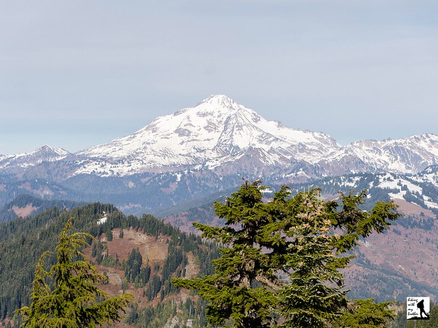
 The 360-degree views are vast. To the north, Glacier Peak rises above the surrounding mountains. Pick out Columbia, Kyes and Sloan Peaks to the left of Glacier. Continue turning west to first pick out Del Campo Peak and Big Four Mountain, followed by Gunn and Merchant Peak, then Baring Mountain. As you turn south find Mt. Rainier dominating the skyline, rising over nearby Beckler Peak and Alpine Baldy. As you turn east find Mount Daniel and Mount Fernow, followed by Mount Stewart and finally the rolling mountains of the Henry M. Jackson Wilderness including nearby Scrabble Mountain and Grizzly Peak. Settle in and see how many more you can pick out.
Despite the roughly 20 miles of forest roads that must be navigated to reach the trailhead, the spectacular views draw plenty of hikers every year. While is a great hike if you’re looking for big rewards on a short trail, it’s a lot of driving for just over 2.5 miles of trail. The trail is probably a little too steep and rugged for the youngest of hikers, but everyone else should be able to tackle this one without too much of a problem. If you’re looking for more trail time, we recommend combining this hike with another nearby trail, such as Beckler Peak or Scorpion Mountain.

Print Google Directions >>
6 Comments:
I am so inspired by your guys hikes and shall have to include this one for next year! X
I spent the summer at Evergreen for the forest service in 1981 or so...loved the mountain and the wildlife. saw one snag burn during a rain/lightning storm. also saw the northern lights over Glacier peak..the lookout was in sad shape in those days...nice to know it has been restored.
I remember the 67 burn, watching from McClellan Butte. Prodigious fire, uncommon on this side of the Cascades.
Nice post! If you and your brother liked this you would love the smoky mountains! You should check it out smokymountainstraveltips.blogspot.com/
Do you post somewhere when you did each hike? What time of year? It would be nice to know how your description fits into the time of year and changing weather. Love the blog, btw. Thank you,.
Hi Laura,
The easiest way to figure that would would be look at our photo albums on Picasa which are organized by the date of the hike.
https://picasaweb.google.com/110833407657914921392?noredirect=1
Hope that helps!
Jer
Post a Comment