Total Ascent: 250ft out
Highest Point: 250ft
Total Distance: 4.0 miles
Location: N 47° 52.6683, W 124° 35.2566
Required Permit: None
Difficulty: Easy
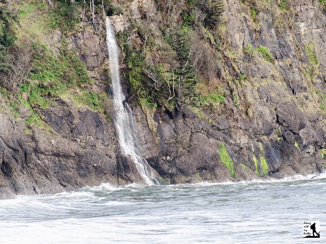
 A few months ago we took a weekend to head out to the Olympic coast to explore some of the beach hikes near La Push. Somewhat remote and a little on the wild side, the three La Push beaches are separated by headlands that jut forcefully into the Pacific. One of the more popular hikes is Third Beach, named for its distance from La Push. Boasting a scattering of seastacks and a tumbling waterfall, Third Beach is a classic Olympic coast hike.
Back in 1898, prospectors began investigating areas around Third Beach for oil. An area near the north end of Third Beach was identified as a potential site and work began to install an oil well at that location. The remoteness of the beach made the project much more challenging than investors expected. At least one barge carrying equipment for the well broke up against the rocky shore, though enough equipment was salvaged to keep the project alive. By 1902 the first oil well on the Olympic coast was in operation, but drilling only managed to struggle down about 650 feet before the well collapsed and the project was abandoned. Originally the access road to the oil well, the original trail to Third Beach led through the rusting remains of the ill-fated project. The trail has since been rerouted, though it is still possible to find what remains of the engines, boilers and pipes of the La Push Oil Well in the underbrush of Third Beach.
The trail begins from the roadside trailhead, immediately diving into a mossy forest of spruce and hemlock following what remains of the oil well access road. Before long the road yields to a fern-lined trail that veers toward the ocean. After about a mile the trail begins its descent to the beach, eventually crossing Newbert Creek and delivering you to the sand at the 1.3 mile mark. Look out across the water to see the seastacks rising out of Strawberry Bay. The headland to the north is Teahwhit Head; to the south is Taylor Point; and between these two craggy bookends there is about a mile of beach to explore and enjoy. Head south toward Taylor Point to get a better look at the waterfall spilling into the sea from the cliffs above. Stake out a section of beach and watch the waves roll in.
 If you’re looking for the right balance of wild Olympic Coast and easy access, it’s hard to beat Third Beach. With a trailhead just off the highway and a well-maintained trail that delivers you to the shore in just over a mile, Third Beach is easily accessible for hikers of almost any age. There are a few campsites in the area for those looking to make an overnight stay. If you’re looking to add a little more milage, Second Beach is just down the road and makes for an easy addition to a day of hiking.
To get to there, take the Bainbridge Island ferry to Bainbridge Island. From the terminal, follow SR 305 for 13 miles to SR 3 North. Follow SR 3 to the Hood Canal Bridge, taking a left over the bridge onto State Route 104. Follow SR 104 as it merges onto US 101 and continue 35 miles to Port Angeles taking a left on Lincoln Street, which becomes US 101. Continue for about 54 miles to the junction to La Push Road, also known as SR 110. Turn right and continue on SR 110 for 7.8 miles to Mora Road. Veer left and continue another 3.8 miles to the trailhead and parking area on the left side of the road. -Nathan
Print Google Directions >>


0 Comments:
Post a Comment