


Total Ascent: 1000ft
Highest Point: 1500ft
Total Distance: 4.2 miles
Location: N 47° 47.418, W 121° 34.212
Required Permit: Northwest Forest Pass
Difficulty: Moderate
 During our research on the Lake Serene Trail #1068, we ran into a number of references to different mines that could be found on the slopes of Mt. Index. Curious, we made a few return trips to the area to see if we could find some of the area’s rich mining past. After some bushwacking and creative route finding, we were able to locate two mines just off the main trail: The Honeymoon Mine and the Index-Independent Mine.
 Back in 1898, the promise of mineral wealth brought prospectors to Mt. Index. A number of exploratory tunnels were dug before claims were staked. The Index Mining Company had the largest concentration of claims, which included Mystery, Pride of Index, Sixteen to One, the Crown Jewel and the Copper Queen. By 1902, the Independent Mining Company had become involved and the claims were collectively known as the Index-Independent Mine. Most of the work was on the Sixteen to One claim, which included three tunnels, each hewn from the rock at progressively higher elevations. The largest was at the lowest elevation, and can still be accessed today. From 1902-1907, copper ore was mined and sent down the mountain to Index. The mine was then abandoned until 1949, when the Lake Serene Mining Company took over and worked the claim until 1951. For this reason, the mine is sometimes referred to as the Lake Serene Mine. As for the Honeymoon Mine, less is known about it, as it is less a mine than simply a tunnel into the mountainside. It never produced much of anything, and after chipping out 250 feet of rock, the effort was abandoned.
The hike begins from the Lake Serene Trailhead, following a logging road for .1 miles before branching off onto the Lake Serene Trail. Enjoy the wide, relatively flat trail as it continues gradually through a mixed forest, crossing over a number of small creeks and streams. This portion of the trail follows an abandoned roadbed, one that was likely used to transport minerals down from the mines. While nature has done a decent job of reclaiming the former road, there are a few sections that feel like a truck filled with coal could come rumbling around the corner. This is especially true for those shadowy sections that run alongside the rocky cliffs created when the road was blasted from the mountainside.
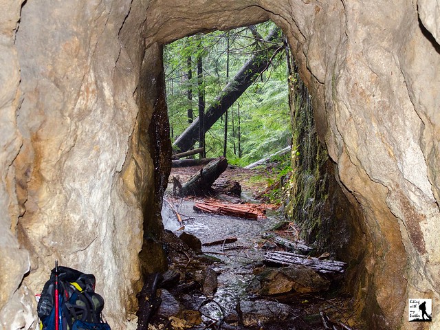
 After 1.5 miles you’ll pass a forest road branching left off the main trail. Ignore this road and continue a short distance to another road branching off to the right. Turn right and follow the road for a little less than .2 miles to a large clearing, once the parking lot for the Lake Serene Trailhead. From here, listen for the nearby creek as it tumbles down the cliffs above. The Index-Independent Mine is tucked into the cliffs next to the creek, and a rough bootpath leads up to the tunnel. Also nearby is a memorial to three hikers that were killed in an avalanche here in late 1996. Find it by following what remains of the roadbed a few hundred feet up to the rock face, and following the path to a small stone circle. Once you’re done exploring the area, head back down to the main trail and continue about .1 miles to a junction with the Bridal Veil Falls Trail.
Head right up the rocky Bridal Veil Falls trail, crossing over a few large streams and catching the occasional view of the South Fork Skykomish Valley. Continue switchbacking up the trail, and as you approach the crashing sound of Bridal Veil Falls, keep an eye out for the first in a series of wooden boardwalks. From the first boardwalk, turn right into the forest, heading toward a small waterfall a few dozen feet up the mountain, largely hidden in the trees. As you work your way toward the water, find a small gully providing easy access up the mountainside. After a short scramble you’ll end up on a small plateau at the base of the falls. The Honeymoon Mine is just to the left of the falls. After you’ve had your fill of the mine, head back down and spend some time at Bridal Veil Falls and the big views of the valley below.
 Because they are fairly low on the mountain, these mines are a great winter outing or they work well as side trips on your way up to Lake Serene. The lack of real trails to the mines means that this adventure may not be for everyone, but they are so close to the trail that if you don’t mind some off-trail explorations you won’t have much difficulty reaching the mines. As always, use caution around the tunnels, as they can be dangerous. Do not enter the mines unless you have the appropriate gear and experience to do so.
To get there, take Highway 2 out toward Index. Keep an eye out for the Mt. Index road on the right near milepost 35. Take the Mt. Index Road for about a half-mile, following the signs directing you to the Lake Serene Trailhead and parking lot. Privy available. -Nathan
Print Google Directions >>
0 Comments:
Post a Comment