


Total Ascent: 100ft
Highest Point: 500ft
Total Distance: 10.6 miles
Location: N 48° 16.5648, W 121° 42.3517
Required Permit: None
Difficulty: Easy
 A few months ago, we were looking for a low elevation hike to explore while waited for the snows to recede from the mountaintops. After some consideration, we headed north to wander down a portion of the Whitehorse Trail, a rails-to-trails project that follows a railroad spur that once ran between Arlington to Darrington.
 In 1901, the Northern Pacific Railroad finished laying down nearly 30 miles of track out to Darrington, and that same year the first train arrived ready to haul freshly mined ore back to Arlington and eventually Everett. However, the mines overpromised and under-
 delivered, and soon ore gave way to trains nearly overflowing with timber. Over the years, nearly a dozen small sawmills cropped up along the route, with many eventually developing into station stops that each have their own little slice of history. After Darrington struggled through the Great Depression, the timber helped fuel the town’s post-war boom.
 But timber sales eventually began to wane. By the 1980s, planners began to eye the underused railroad as a possible recreation site, modeling a proposal based on other rails-to-trails projects like the Iron Horse Trail. In 1991, the railroad – today known as the Burlington Northern Santa Fe (BNSF) – formally abandoned the route and in 1994 work began to remove the tracks. After about two decades of work, today less than 6 miles of the 27-mile trail are officially open to the public, mostly due to lack of funds necessary to make the 16 bridges and other structures along the corridor safe for public use. And the name? That’s taken from the prominent Whitehorse Mountain the hike treks past, which was named in 1894 by W.C. Hiles, Darrington’s first postmaster, for the image of a horse he saw outlined in the snow as it melted each spring.
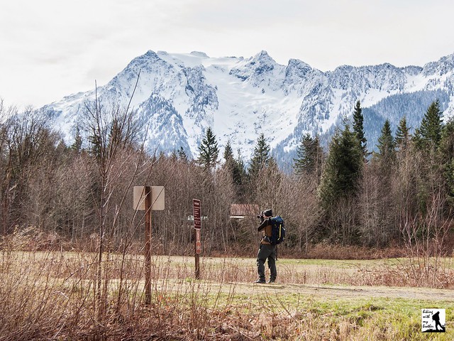
Although you can start on either end of this trail, we recommend hiking from Swede Heaven Road toward Darrington. From the Swede Heaven Trailhead, the trail begins on a quiet neighborhood street, and wanders into a mixed forest following the North Fork Stillaguamish. The
 river, though sometimes obscured behind a thin wall of trees, makes a pleasant walking companion as you continue down the graveled railbed. The hike will take you over streams, across roads, and through Darrington Bluegrass Music Park’s amphitheater where you can catch views of Whitehorse Mountain looming nearby.
Around the half-way point, you’ll reach Riverbend, where the North Fork Stillaguamish peels away from the trail and the trees open up for views of the mountains to the north, including Mt. Higgins, Round Mountain, and North Mountain. If you’re looking for a shorter day, follow the trails leading down to the river for a decent picnic location. But, if you’re looking for more, continue onward, passing through a swath of powerlines and into the most remote section of the trail. Enjoy a mile or so of quiet forest before encountering the edges of a logging operation. Find the other end of the trail not too long after.
This is a great choice for an off-season hike. Flat and wide, it’s approachable for any hiker and is also popular with bikers. While most of the trail abuts backyards, logging mills and other trappings of civilization, the occasional views are good and sections of
 trail do manage to feel like you’re deeper in the forest than you are. If you’re looking for more adventure, the Snohomish County Park Service clears out the rail corridor between Arlington and Swede Heaven Road every year, making it easier for folks to cautiously explore the roughly 20 miles of trail still officially closed to public use.
To get there, take I-5 north to Exit 208 and drive east on SR 530 22.5 miles to Swede Heaven Road. Take a left and find the trail a half-mile down the road. There is a small amount of parking here, otherwise head back out to SR 530 to find parking. If you prefer to start in Darrington, continue on SR 530 into Darrington to Railroad Avenue. Take a left and find the trailhead and a small parking lot at the end of the road. -Nathan
Print Google Directions >>
1 Comments:
You hike, I ride my horse! Great post & photos of one of my favorite trails! Come to a committee meeting with any input - we need the support!
Post a Comment